
The island of Ireland, comprising Northern Ireland and the Republic of Ireland, has an extensive network of tens of thousands of kilometres of public roads, usually surfaced. These roads have been developed and modernised over centuries, from trackways suitable only for walkers and horses, to surfaced roads including modern motorways. The major routes were established before Irish independence and consequently take little cognisance of the border other than a change of identification number and street furniture. Northern Ireland has had motorways since 1962, and has a well-developed network of primary, secondary and local routes. The Republic started work on its motorway network in the early 1980s; and historically, the road network there was once somewhat less well developed. However, the Celtic Tiger economic boom and an influx of European Union structural funding, saw national roads and regional roads in the Republic come up to international standard quite quickly. In the mid-1990s, for example, the Republic went from having only a few short sections of motorway to a network of motorways, dual carriageways and other improvements on most major routes as part of a National Development Plan. Road construction in Northern Ireland now tends to proceed at a slower pace than in the Republic, although a number of important bypasses and upgrades to dual carriageway have recently been completed or are about to begin.

County Offaly is a county in Ireland. It is part of the Eastern and Midland Region and the province of Leinster. It is named after the ancient Kingdom of Uí Failghe. It was formerly known as King's County, in honour of Philip II of Spain. Offaly County Council is the local authority for the county. The county population was 77,961 at the 2016 census.

Banagher is a town in Ireland, located in the midlands, on the western edge of County Offaly in the province of Leinster, on the banks of the River Shannon. It had a population of 3,000 at the height of its economic growth in the mid-19th century; as of 2016, the population was over 1,700.

The R30 is a provincial route in South Africa that connects Bloemfontein with Rustenburg via Brandfort, Welkom, Bothaville, Klerksdorp and Ventersdorp. The southern part of the route is tolled, as the R30 forms the first section of the ZR Mahabane Toll Route, with the Brandfort Toll Plaza found 10 kilometres north of its Southern junction with the N1 National Route. The tolled portion ends at the junction with the R730.

The R34 is a long provincial route in South Africa that connects Vryburg with Richards Bay via Kroonstad and Newcastle. It passes through three provinces, North West, the Free State and KwaZulu-Natal.

The R38 is a provincial route in South Africa that connects Standerton with Kaapmuiden via Bethal, Carolina and Barberton. It is a main route through the province of Mpumalanga.

The R56 is a provincial route in South Africa that connects Middelburg with Pietermaritzburg via Molteno, Maclear and Kokstad. It is co-signed with the N2 between Kokstad and Stafford's Post for 39 kilometres.

The R445 road is a regional road in Ireland. The route is a non-motorway alternative route to the N7/M7 motorway between Naas and Limerick, and at 170 km it is one of the longest regional roads in Ireland. Indeed, much of the route comprises roads that were formerly part of the N7 between the cities, prior to motorway and other bypasses. Some of the R445 route also comprises local link roads to new N7/M7 route sections.
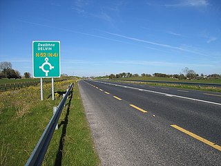
The N52 road is a national secondary road in Ireland. It links the M7 motorway from just south of Nenagh, County Tipperary to the M1 motorway north of Dundalk in County Louth. The route forms a connection between the north east of Ireland and the mid west traversing the midlands. It interchanges with the M6 at Kilbeggan and at Tyrrellspass, the N4 at Mullingar, the N3 at Kells, and the N2 at Ardee before continuing towards Dundalk.
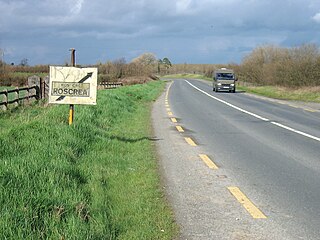
The N62 road is a national secondary road in Ireland. It links the M6 motorway east of Athlone, County Westmeath with junction 6 of the M8 motorway at Kilnoe near Horse and Jockey in County Tipperary, 96.625 kilometres (60.040 mi) to the south. The route also forms a junction with the M7 motorway south of Roscrea.

The R747 road is a regional road in Ireland running north-west/south-east from the M9 near Ballitore in County Kildare to Arklow in County Wicklow, a distance of 66 km (41 mi).

The R446 road is a regional road in Ireland. The road connects Kinnegad in County Westmeath to Galway City. Prior to the construction of the M6 motorway the R446 formed the main N6 road connecting Dublin and Galway. Following the opening of the M6; the old N6 road was downgraded to regional road status and was designated as the R446. The road is an alternative route between Galway and Dublin and runs in parallel to the M6.

The R323 road is a regional road in County Mayo, Ireland. Going from west to east, the route connects the towns of Kiltimagh, Knock, and Ballyhaunis. En route it crosses over the N17 national primary road at a grade separated junction in the village of Knock.

The R421 road is a regional road in Ireland which runs southwest-northeast from the R445 south of Roscrea to the N52 north of Tullamore. The route also passes through Clareen, Kinnitty and Killurin. The bulk of the route is in County Offaly with small sections in counties Tipperary and Laois. The route is 50 km (31 mi) long.

The R420 road is a regional road in Ireland, which runs northwest-southeast from the R446 near Moate in County Westmeath to the R445 just west of Monasterevin. The road travels through the towns of Clara, Tullamore & Portarlington.

The R448 road is a regional road in Ireland. It is the designation given to the former N9 national primary road when it was bypassed by the M9 motorway.

The R125 road is a regional road in Ireland, linking Kilcock on the County Meath / County Kildare border to Swords in County Dublin via the towns of Dunshaughlin and Ratoath.

The N18 is a national route in South Africa which runs from Warrenton through Vryburg and Mahikeng to Ramatlabama on the border with Botswana.

The R320 road is a regional road in east County Mayo in Ireland. It connects Swinford to Claremorris via Kiltimagh, and links the N5 and N26 roads near Swinford with the N60 and N17 roads near Claremorris. The R320 connects with six other regional roads along its route. The road is in three discontiguous segments which add up to 27.1 kilometres (16.8 mi) in length.

The R356 road is a regional road in Ireland; it links Killimor, County Galway with Cloghan, County Offaly. The road also travels through the towns of Eyrecourt and Banagher. At Banagher, the road crosses the River Shannon via a seven arch bridge. This bridge was erected by the Commissioners for the Improvement of Navigation of the Shannon in 1841–1843.
