The island of Ireland, comprising Northern Ireland and the Republic of Ireland, has an extensive network of tens of thousands of kilometres of public roads, usually surfaced. These roads have been developed and modernised over centuries, from trackways suitable only for walkers and horses, to surfaced roads including modern motorways. The major routes were established before Irish independence and consequently take little cognisance of the border other than a change of identification number and street furniture. Northern Ireland has had motorways since 1962, and has a well-developed network of primary, secondary and local routes. The Republic started work on its motorway network in the early 1980s; and historically, the road network there was once somewhat less well developed. However, the Celtic Tiger economic boom and an influx of European Union structural funding, saw national roads and regional roads in the Republic come up to international standard quite quickly. In the mid-1990s, for example, the Republic went from having only a few short sections of motorway to a network of motorways, dual carriageways and other improvements on most major routes as part of a National Development Plan. Road construction in Northern Ireland now tends to proceed at a slower pace than in the Republic, although a number of important bypasses and upgrades to dual carriageway have recently been completed or are about to begin.
Sliabh Luachra, sometimes anglicised Slieve Logher, is an upland region in Munster, Ireland. It is on the borders of counties Cork, Kerry and Limerick, and bounded to the south by the River Blackwater. It includes the Mullaghareirk Mountains.
Kanturk is a town in the north west of County Cork, Ireland. It is situated at the confluence of the Allua (Allow) and Dallow (Dalua) rivers, which stream further on as tributaries to the River Blackwater. It is about 50 kilometres from Cork, Blarney and Limerick, and lies just north of the main N72 road, 15 km from Mallow and about 40 km from Killarney. Kanturk is within the Cork North-West Dáil constituency.
Tournafulla, or Toornafulla, is a village in the southwest of County Limerick, Ireland. Tournafulla is a long single-street village. It has a Catholic church, a primary school, three pubs, a community hall and a GAA pitch. As of the 2016 census, the village had a population of 144 people.

The N12 road is one of the shortest national primary roads in the Republic of Ireland, running 6.87 km (4.27 mi) from outside Monaghan to the border with County Armagh, Northern Ireland, at Ardgonnell Bridge outside Middletown. The N12 is part of an overall route running from Cavan Town to Belfast.

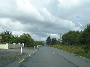
A regional road in the Republic of Ireland is a class of road not forming a major route, but nevertheless forming a link in the national route network. There are over 11,600 kilometres of regional roads. Regional roads are numbered with three-digit route numbers, prefixed by "R". The equivalent road category in Northern Ireland are B roads.

The R445 road is a regional road in Ireland. The route is a non-motorway alternative route to the N7/M7 motorway between Naas and Limerick, and at 170 km it is one of the longest regional roads in Ireland. Indeed, much of the route comprises roads that were formerly part of the N7 between the cities, prior to motorway and other bypasses. Some of the R445 route also comprises local link roads to new N7/M7 route sections.

A national secondary road is a category of road in Ireland. These roads form an important part of the national route network but are secondary to the main arterial routes which are classified as national primary roads. National secondary roads are designated with route numbers higher than those used for primary roads, but with the same "N" prefix. Routes N51 and higher are all national secondary roads.
The Mullaghareirk Mountains is a range of hills in Ireland on the borders of County Cork, County Kerry and County Limerick. The area is also known as Sliabh Luachra. The highest point is Baraveha at 451 metres (1,480 ft). It is bordered by the Blackwater valley to the south, Castleisland to the west, Athea to the north and the Deel valley to the east. Villages in the hills include Rockchapel, Ballydesmond, Brosna, Gneevgullia, Mountcollins, Newmarket, Meelin and Tournafulla. The Allaughaun River, a tributary of the River Feale, rises at the east end of the range.
Rockchapel is a village in north County Cork in Ireland. It is located near the border of counties Cork, Kerry and Limerick. Rockchapel is within the Dáil constituency of Cork North-West.
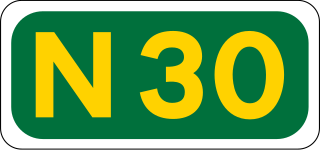
The N30 road is a national primary road in Ireland. It connects the N25 road and M11 motorway, providing a link running east-northeast through County Wexford, between New Ross and Enniscorthy. This provides for a more direct national route between the two towns, as the N25 and N11 both run to Wexford town, eastwards from New Ross and southwards from Enniscorthy respectively.

The N72 road is a national secondary road in Ireland that runs east-west from its junction with the N25 near Dungarvan in County Waterford to the N70 in Killorglin in County Kerry.

Newmarket, historically known as Aghatrasna, is a town in the barony of Duhallow, County Cork, Ireland. It is situated at the junction of the R576 and R578 regional roads. Newmarket is within the Cork North-West Dáil constituency
The Duhallow Junior A Football Championship is the top footballing competition in the Duhallow division in Cork. It was first run after the formation of the Duhallow division in 1933. The Championship includes a group stage, therefore every team has at least 2 matches. The winners and runner up of this competition go on to compete in the Cork Junior A Football Championship.

The R639 road is one of Ireland's regional roads. Once designated the N8 national primary road, it was reclassified in stages as the R639 following the progressive opening of sections of the M8 motorway, which rendered the single carriageway N8 redundant as a national primary road. By-passed sections of the old N8 were generally reclassified as R639 as soon as a new section of M8 opened, thereby increasing the length of the R639. With the completion of the M8 on 28 May 2010, the R639 now stretches from Durrow, County Laois to Cork, running through counties Laois, Kilkenny, Tipperary, Limerick and Cork.

The N78 road is a national secondary road in Ireland. The 50-kilometer-long (31 mi) road links the N77 national secondary road north of Kilkenny, County Kilkenny to the M9 national primary route at Mullamast in County Kildare. En route it passes through the towns of Castlecomer in County Kilkenny, Ballylynan in County Laois, and Athy in County Kildare. It is single carriageway throughout.

The R466 road is a regional road in Ireland which runs southeast-northwest from the R445 at Birdhill, County Tipperary to the R352 in East Clare.
Kanturk GAA is a Gaelic Athletic Association club with Gaelic football and hurling teams, based in the town of Kanturk, County Cork, Ireland which forms part of the parish of Kanturk and Lismire. Founded in 1882, the club plays both hurling and football. It is affiliated with Cork GAA and plays in Duhallow division competitions.
The 2021 Cork Premier Intermediate Football Championship was the 16th staging of the Cork Premier Intermediate Football Championship since its establishment by the Cork County Board in 2006. The draw for the group stage placings took place on 29 April 2021. The championship began on 4 September 2021 and ended on 5 December 2021.
The 2022 Cork Premier Intermediate Football Championship is the 17th staging of the Cork Premier Intermediate Football Championship since its establishment by the Cork County Board in 2006. The draw for the group stage placings took place on 8 February 2022. The championship is scheduled to run between 22 July and 23 October 2022.