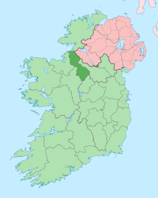
County Leitrim is a county in Ireland. It is in the province of Connacht and is part of the Northern and Western Region. It is named after the village of Leitrim. Leitrim County Council is the local authority for the county, which had a population of 35,087 according to the 2022 census.

Dromahair is a village in County Leitrim in the northern part of Connacht, the western province in Ireland. Dromahair is 10 km (6 mi) from Manorhamilton and 17 km (10 mi) from Sligo town.

Tullaghan is the most northerly village in County Leitrim. Lying at the northern end of Glenade, Tullaghan is in the parish of Kinlough and Glenade and is part of the Manorhamilton electoral area.

The R284 road is a regional road in Ireland linking Sligo to Leitrim village in County Leitrim. En route it passes through Ballygawley, Ballyfarnan, Geevagh and Keadue. The road is 46 km (29 mi) long.

The R282 road is a regional road in County Leitrim, Ireland connecting the N16 in Manorhamilton with Rossinver and across the border around Lough Melvin becoming the B53 to Garrison, County Fermanagh.

The R291 road is a regional road in Ireland linking Sligo and Rosses Point in County Sligo. The road is part of the Wild Atlantic Way.

The R279 road is a regional road in Ireland linking Cliffoney and Mullaghmore in County Sligo. The 19th century Classiebawn Castle is located on this road just before entering Mullaghmore. The entire road is part of the Wild Atlantic Way, which continues around Mullaghmore Head after the end of the R279.

The R277 road is a regional road in Ireland linking the R292 road from just outside Strandhill to Sligo Airport (Strandhill) in County Sligo. The airport access section of the road, Airport Road, is the site of the Sligo Airport Business Park, a technology and enterprise centre hosting 17 companies.

The R281 road is a regional road in Ireland linking Kinlough and Glenfarne in County Leitrim.

The R286 road is a regional road in Ireland. It is largely a loop road from the N16 linking Sligo and north County Leitrim.
The R278 road is a regional road in Ireland. It is a loop road from the R286 road in Counties Sligo and Leitrim.
The R288 road is a regional road in Ireland. It connects the R287 and R286 roads in County Leitrim.

The R289 road is a regional road in Ireland linking the R287 and the R280 in County Leitrim. The road is 5.9 km (3.7 mi) long.

The R290 road is a regional road in Ireland linking the R287 and the N59 in County Sligo.

The R298 road is a regional road in Ireland linking the R297 road near Enniscrone with the N59, entirely in County Sligo. The R298 is 4.9 km (3.0 mi) long.

The R199 road is a regional road in Ireland linking the R198 and R202 roads in Counties Cavan and Leitrim. It is a key road for access to the Shannon–Erne Waterway.

The R205 road is a regional road in Ireland from the R199 road in County Leitrim to the Northern Ireland border at County Fermanagh, mostly in County Cavan. A number of factories of the former Quinn Group are located along the road.
The R208 road is a regional road in Ireland linking the R280 and R202 roads in County Leitrim.

The R210 road is a regional road in Ireland linking the R209 and R208 roads in south county Leitrim. Approximately 1.9 km (1.2 mi) in length, the R210 road runs along the south-east border of Carrickaport Lough and also runs along the north-west border of Lough Scur over Drumcong townland, the placename in Irish: Droim Conga translating to "Ridge of the narrow neck".

The R299 road is a regional road in Ireland linking the N4 and R280 roads in County Leitrim. The road is 7.8 kilometres (4.8 mi) long northbound, shorter southbound.

