Dundalk is the county town of County Louth, Ireland. The town is on the Castletown River, which flows into Dundalk Bay on the east coast of Ireland. It is halfway between Dublin and Belfast, close to the border with Northern Ireland. It is surrounded by several townlands and villages that form the wider Dundalk Municipal District. It is the seventh largest urban area in Ireland, with a population of 43,112 as of the 2022 census.
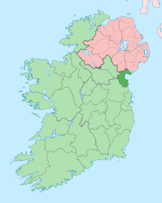
County Louth is a coastal county in the Eastern and Midland Region of Ireland, within the province of Leinster. Louth is bordered by the counties of Meath to the south, Monaghan to the west, Armagh to the north and Down to the north-east, across Carlingford Lough. It is the smallest county in Ireland by land area and the 17th most populous, with just over 139,100 residents as of 2022. The county is named after the village of Louth. Louth County Council is the local authority for the county.
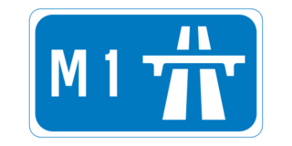
The M1 motorway is a motorway in Ireland. It forms the large majority of the N1 national primary road connecting Dublin towards Belfast along the east of the island of Ireland. The route heads north via Swords, Drogheda and Dundalk to the Northern Irish border just south of Newry in County Armagh, where it joins the A1 road and further on, the M1 motorway in Northern Ireland. It also forms a significant part of the road connection between Dublin and the Northern Irish cities of Newry, and Lisburn. The route is part of European route E01.

Warrenpoint is a small port town and civil parish in County Down, Northern Ireland. It sits at the head of Carlingford Lough, south of Newry, and is separated from the Republic of Ireland by a narrow strait. The town is beside the village of Rostrevor and is overlooked by the Mournes and Cooley Mountains. Warrenpoint sprang up within the townland of Ringmackilroy, and is locally nicknamed "The Point", which also represents the town's full name in Irish, An Pointe".
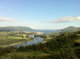
Carlingford Lough is a glacial fjord or sea inlet in northeastern Ireland, forming part of the border between Northern Ireland to the north and the Republic of Ireland to the south. On its northern shore is County Down, the Mourne Mountains, and the town of Warrenpoint; on its southern shore is County Louth, the Cooley Mountains and the village of Carlingford. The Newry River flows into the loch from the northwest.

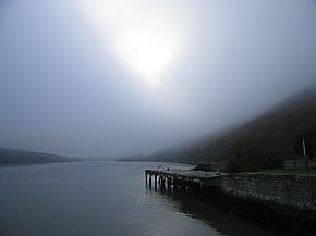
Greenore is a village, townland and deep water port on Carlingford Lough in County Louth, Ireland.

Carlingford is a coastal town and civil parish in northern County Louth, Ireland. For the purposes of local government, the town is part of the Dundalk Municipal District. It is situated on the southern shore of Carlingford Lough with Slieve Foy mountain as a backdrop, sometimes known as Carlingford Mountain. It is the main town on the Cooley Peninsula. Located on the R176/R173 roads between Greenore and Omeath village, Carlingford is approximately 27 km (17 mi) north east from Dundalk, 90 km (56 mi) north of Dublin and 11 km (7 mi) south of the border with Northern Ireland. Carlingford won the Irish Tidy Towns Competition in 1988.

The R176 road is a regional road in Ireland, running its full length on the Cooley Peninsula in County Louth. It runs between its junction with R173 at Ghan Road, Carlingford and its junction with R175 at Saint James' Well via Carlingford Relief Road and Mullatee.

The R175 road is a regional road in Ireland, running its full length on the Cooley Peninsula in County Louth. It runs northeast from its junction with the R173 at The Bush to its terminal point at Greenore Port via Rogan's Cross, Saint James' Well; and the Shore Road at Greenore all in the County Louth. Two kilometres south of Greenore it is joined by the R176 from nearby Carlingford. The road is 6 km (3.7 mi) long.

The Republic of Ireland–United Kingdom border, sometimes referred to as the Irish border or British–Irish border, runs for 499 km (310 mi) from Lough Foyle in the north-west of Ireland to Carlingford Lough in the north-east, separating the Republic of Ireland from Northern Ireland.

The A2 is a major road in Northern Ireland, a considerable length of which is often referred to the Antrim Coast Road because much of it follows the scenic coastline of County Antrim; other parts of the road follow the coasts in Counties Down and Londonderry.

Omeath is a village on the Cooley Peninsula in County Louth, Ireland, close to the border with Northern Ireland. It is roughly midway between Dublin and Belfast, very near the County Louth and County Armagh / County Down border. As of the 2016 census, Omeath had a population of 603, up from 439 during the 2006 census. It is approximately 6 km (3.7 mi) from Carlingford and about 8 km (5.0 mi) from Newry. By sea, Omeath's nearest land neighbour is Warrenpoint on the south County Down coast.
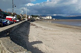
Blackrock is a seaside village just to the south of Dundalk, County Louth, Ireland. The village is in the townland of Haggardstown, in the Barony of Upper Dundalk, and part of the Dundalk metropolitan area. The population of the village is approximately 3,000.
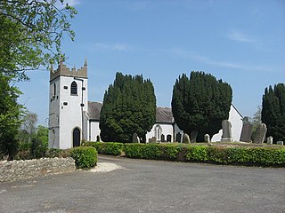
Ballymascanlan, otherwise Ballymascanlon, is a small village and townland in County Louth, Ireland. It is 4 km (2.5 mi) north-east of Dundalk on the Cooley Peninsula, on the road to Carlingford. The village is in a civil parish of the same name.

Clermont Carn, also known as Black Mountain, is a mountain that rises to 510 metres (1,670 ft) in the Cooley Mountains of County Louth, Ireland. It is at the border with Northern Ireland, and is also the location of the Clermont Carn transmission site. The mountain's name refers to an ancient burial cairn on its summit, and to Lord Clermont of Ravensdale.

The Cooley Peninsula is a hilly peninsula in the north of County Louth on the east coast of Ireland; the peninsula includes the small town of Carlingford, the port of Greenore and the village of Omeath.

Ravensdale is a village, townland and electoral division located at the foothills of the Cooley Mountains on the Cooley Peninsula in the north of County Louth in Ireland. Bordering with the townland of Doolargy, Ravensdale is approximately 8 km to the north of Dundalk. The dual carriageway between Dublin and Belfast runs nearby, and the R174 connects it with Jenkinstown.

The Táin Way is a long-distance trail around the Cooley Peninsula in County Louth, Ireland. It is a 40-kilometre (25-mile) long circular route that begins and ends in Carlingford. It is typically completed in two days. It is designated as a National Waymarked Trail by the National Trails Office of the Irish Sports Council and is managed by Louth County Council, Coillte and the Walks Partnership Group.

Erin McGreehan is an Irish Fianna Fáil politician who has served as a Senator since June 2020, after being nominated by the Taoiseach.
Bellurgan is a townland in the northeast of County Louth, Ireland. Located approximately 6km from the town centre of Dundalk, as of the 2011 census the townland had a population of 665 people. Bellurgan townland has an area of approximately 8.44 square kilometres (3.26 sq mi).