R639 road (Ireland)

Last updated

IRL R639.svg
R639 road
Bóthar R639
Location
Country Ireland
Highway system
The R639 between Cahir and Skeheenarinky, built after 1811. The R639 empty - Ireland.JPG
The R639 between Cahir and Skeheenarinky, built after 1811.

The R639 road is one of Ireland's regional roads. Once designated the N8 national primary road (and before that some fractions were designated as the T6 and others as the T9), it was reclassified in stages as the R639 following the progressive opening of sections of the M8 motorway, which rendered the single carriageway N8 redundant as a national primary road. By-passed sections of the old N8 were generally reclassified as R639 as soon as a new section of M8 opened, thereby increasing the length of the R639. With the completion of the M8 on 28 May 2010, the R639 now stretches from Durrow, County Laois to Cork, running through counties Laois, Kilkenny, Tipperary, Limerick and Cork.

Contents

Route

The R639 leaving Fermoy heading south IMG R639Fermoy5656w.jpg
The R639 leaving Fermoy heading south

The R639 runs parallel to the M8 from its junction with the N77 in Durrow in County Laois to the N8 on the Lower Glanmire Road 1.5 km west of the Dunkettle Interchange on the outskirts of Cork City. North to south, it passes through Durrow, Cullahill, Johnstown, Urlingford, Littleton, Horse and Jockey, Cashel, and New Inn; and from there it runs south-west around Cahir and on through Skeheenarinky before entering County Limerick and passing through the village of Kilbeheny before veering west of Mitchelstown and proceeding south along Kilworth Mountain and through Fermoy, Rathcormack, Watergrasshill, Sallybrook and Glanmire, terminating at the N8 Lower Glanmire Road.

The official description of the R639 from the Roads Act 1993 (Classification of Regional Roads) Order 2012 [1] reads:

R639: Durrow, County Laois – Cashel – Caher, County Tipperary – Mitchelstown – Fermoy – Dunkettle, County Cork (Part Old National Route 8)
Between its junction with the N77 at Mary Street Durrow in the county of Laois and its junction with N74 at Owen’s and Bigg’s Lot in the county of South Tipperary via Castle Street and Patrick Street at Durrow; and Cullahill in the county of Laois: Coolnacrutta; Chapel Street, The Square and Urlingford Road at Johnstown; Mountfin and Main Street at Urlingford in the county of Kilkenny: Fennor in the county of South Tipperary: Longfordpass Bridge at the boundary between the county of South Tipperary and the county of North Tipperary: Turnpike, Littleton and Horse and Jockey in the county of North Tipperary: Ballytarsna, Gortmakellis and Corralough in the county of South Tipperary: Dublin Road, Ladywell Street, Canopy Street, Bank Place, Main Street and Lower Gate Street in the town of Cashel: and Spafield in the county of South Tipperary
and
between its junction with N74 at Owen’s and Bigg’s Lot and its junction with N24 at Cloghabreedy via Racecourse Cross and New Inn all in the county of South Tipperary
and
between its junction with N24 at Ballydrehid in the county of South Tipperary and its junction with N73 at Carrigane in the county of Cork via Lissava, Kilcoran and Skeheenaranky in the county of South Tipperary: Brackbaun Bridge at the boundary between the county of South Tipperary and the county of Limerick: Kilbehenny in the county of Limerick: Kilbehenny Bridge at the boundary between the county of Limerick and the county of Cork
and
between its junction with N73 at Stag Park in the county of Cork and its junction with N72 at Church Place in the town of Fermoy via Gortnahown, Monadrishane and Gortore in the county of Cork: and Oliver Plunket Hill in the town of Fermoy
and
between its junction with N72 at Pearse Square in the town of Fermoy and its junction with the N8 at Lota More in the county of Cork via McCurtain Street, McDonagh Terrace and Cork Road in the town of Fermoy: Rathcormack, Curraghprevin, Skahanagh North, Watergrasshill, Annacarton Bridge, Killydonoghoe, Ballincrossig and Glanmire in the county of Cork.

History

Tipperary, as shown in Herman Moll's New Map of Ireland (1714). The present R639 may be discerned between Cahir and Cashel only; it existed neither south of Cahir nor north of Cashel at this time. Tipperary 1714.JPG
Tipperary, as shown in Herman Moll's New Map of Ireland (1714). The present R639 may be discerned between Cahir and Cashel only; it existed neither south of Cahir nor north of Cashel at this time.

18th and 19th centuries

In the 17th, 18th and early to mid-19th centuries – and probably earlier still – horse-drawn Dublin-Cork traffic travelled via Kilcullen, Carlow, Kilkenny, Clonmel, Ardfinnan, Clogheen, Ballyporeen, Kilworth, Fermoy and Rathcormac. Much of the R639/N8 route was built to connect the midlands to southern Tipperary and north County Cork as part of the Irish turnpike road-building drive of the mid-18th century. [2] However, some sections are considerably older, such as the segment between Cork and Fermoy, and that between Cashel and Cahir; the construction of these particular stretches cannot as yet be dated, though they were in place prior to 1714. [3] The R639/N8 between Fermoy and Cahir via Mitchelstown was built sometime after 1811, [4] [5] while the R639 between Cashel and Urlingford was built around 1739. At the same time, the route from Urlingford to Maryboro (modern-day Portlaoise) was substantially improved. [6] In 1782 an unnamed English tourist in Ireland, known to historians as "X.Z.", gave a brief description of the route between Cashel and Urlingford: "From Cashel we rode fifteen miles of a bad road, through a bleak country to Urlingford, when we enter Leinster province. The country now becomes more populous, better improved, and the roads much more agreeable for travelling." [7]

20th and 21st centuries

Contemporary signage on the R639. New R639 signage.JPG
Contemporary signage on the R639.

Some time after 1811 the gaps in the R639 between Fermoy and Cahir were filled, [8] but the traditional Cork to Dublin route, known for much of the 20th century as the T6, continued to run from Cork to Cahir, and from there to Dublin via Clonmel, Kilkenny and Carlow. The R639/N8 corridor did not become the official Dublin to Cork road until 1974, though several Esso road atlases considered it to be the preferred route for motorists travelling between the two cities from at least the early 1960s. [9] From this time until the gradual opening of the various M8 motorway segments beginning with the Fermoy Bypass in 2006, the route was known as the "N8".

The N8 was improved at various times during the 1970s through to the early years of the 21st century. One of the first improvements entailed a realignment of the road so that it bypassed the village of Glanmire for 6 km to the east. This dual carriageway bypass, referred to in official documentation as the "Glanmire Bypass", [10] opened in April 1992 after a construction period of almost 7 years. When this happened, the former T6/N8 through Glanmire was renumbered, for the first time, as the "R639". The next major incident in the modern history of the R639 occurred in 1991, when a new 4 km single-carriageway bypass to the south-west of Cahir in County Tipperary opened to traffic. This bypass became a part of the N8 for the next 18 years. With the completion of the M8 motorway through South Tipperary in July 2008 however, the 1991 N8 Cahir Bypass was renumbered as part of the N24 – while simultaneously becoming the R639. (The original route of the N8 through Cahir town was redesignated a regional road in 1991, and made a part of the R670.) Other improvement projects carried out on the road during the 1970s, 80s and 90s involved periodic widening and resurfacing. In spring 2001, attention was turned to Watergrasshill in County Cork. For many years regarded as a serious bottleneck on the N8, a wide median 7 km dual carriageway bypass was constructed and opened to traffic in September 2003 as the N8, with the former road through Watergrasshill becoming the R639. [11] [12] In 2004 the N8 through Cashel in County Tipperary was realigned with a narrow-median dual carriageway bypass to the east of that town. Again, the former N8 through Cashel was redesignated a regional road, and renumbered the R639. In October 2007 the section of N8 between Cashel and Cahir (the same road mapped by Herman Moll in 1714) was bypassed by an early-opening segment of the M8 motorway, and became the most recent addition to the R639 route. This, in turn, was followed in July 2008 by the section between Cahir and Kilbehenny; on 8 December 2008 by the length of road from Cashel to 2 km south of Cullahill in County Laois; on 25 May 2009, by the section between Mitchelstown and Fermoy; and on 28 May 2010 by the length between Durrow and Cullahill.

Landmarks

The R639 approaching Cashel from the north IMG R639Cashel4761w.jpg
The R639 approaching Cashel from the north

The road offers a striking view of the Rock of Cashel and famously skirts around its base on its approach to Cashel town. Visible from the R639 too is Hoare Abbey, also close to Cashel. South of Cahir the R639 passes southwest along the base of the Galtee Mountains, while to the east, the fertile plain of the Golden Vale is observable, with the Knockmealdowns and Comeragh Mountains starkly visible to the east. The R639 also passes by Glengarra Wood and Mitcheltown Cave.

See also

Related Research Articles

<span class="mw-page-title-main">Cahir</span> Town in County Tipperary, Ireland

Cahir is a town in County Tipperary in Ireland. It is also a civil parish in the barony of Iffa and Offa West.

<span class="mw-page-title-main">Roads in Ireland</span> Overview of roads in Ireland

The island of Ireland, comprising Northern Ireland and the Republic of Ireland, has an extensive network of tens of thousands of kilometres of public roads, usually surfaced. These roads have been developed and modernised over centuries, from trackways suitable only for walkers and horses, to surfaced roads including modern motorways. Driving is on the left-hand side of the road. The major routes were established before Irish independence and consequently take little cognisance of the border other than a change of identification number and street furniture. Northern Ireland has had motorways since 1962, and has a well-developed network of primary, secondary and local routes. The Republic started work on its motorway network in the early 1980s; and historically, the road network there was once somewhat less well developed. However, the Celtic Tiger economic boom and an influx of European Union structural funding, saw national roads and regional roads in the Republic come up to international standard quite quickly. In the mid-1990s, for example, the Republic went from having only a few short sections of motorway to a network of motorways, dual carriageways and other improvements on most major routes as part of a National Development Plan. Road construction in Northern Ireland now tends to proceed at a slower pace than in the Republic, although a number of important bypasses and upgrades to dual carriageway have recently been completed or are about to begin.

The N7 road is a national primary road in Ireland, connecting Limerick and Dublin. The majority of the route is motorway standard and is designated as the M7 motorway. At the Rosbrien interchange in Limerick the route continues as the N18 dual carriageway to Shannon and Ennis. The road passes through the midlands of Ireland, and acts as a trunk route out of Dublin for the N8 and N9 national primary routes to Cork and Waterford respectively. It forms part of European route E20.

The N8 road is a national primary road in Ireland, connecting Cork with Dublin via the M7. The N8 is further classified by the United Nations as the entirety of the European route E 201, part of the trans-Europe International E-road network. The road is motorway standard from junction 19 on the M7 to the Dunkettle interchange in Cork City and is designated as the M8 motorway. From here the route continues into Cork city centre and terminates at the N22 road at St. Patrick's Street. The M8 motorway was completed in May 2010, replacing the single carriageway sections of the old N8 and bypassing towns on the main Cork to Dublin road. It is now possible to travel from Cork to Dublin on the M/N8 in about 2 hours 30 minutes. The route commences just south of Portlaoise, and reaches Cork via the midlands and the Golden Vale of Ireland, through Counties Laois, Kilkenny, Tipperary, Limerick and Cork.

<span class="mw-page-title-main">National Development Plan</span> Large infrastructure developments in Ireland

National Development Plan was the title given by the Irish Government to a scheme of organised large-scale expenditure on (mainly) national infrastructure. The first five-year plan ran from 1988 to 1993, the second was a six-year plan from 1994 to 1999 and the third ran as a seven-year plan from 2000 to 2006. A fourth National Development Plan ran from 2007 to 2011. The main elements of the third plan were the development of a national motorway network between the major cities in Ireland. The upgrading of the rail network was a secondary scheme.

<span class="mw-page-title-main">Regional road (Ireland)</span> Class of road in Ireland

A regional road in the Republic of Ireland is a class of road not forming a major route, but nevertheless forming a link in the national route network. There are over 11,600 kilometres of regional roads. Regional roads are numbered with three-digit route numbers, prefixed by "R". The equivalent road category in Northern Ireland are B roads.

<span class="mw-page-title-main">R445 road (Ireland)</span> Road in Ireland

The R445 road is a regional road in Ireland. The route is a non-motorway alternative route to the N7/M7 motorway between Naas and Limerick, and at 170 km it is one of the longest regional roads in Ireland. Indeed, much of the route comprises roads that were formerly part of the N7 between the cities, prior to motorway and other bypasses. Some of the R445 route also comprises local link roads to new N7/M7 route sections.

<span class="mw-page-title-main">National secondary road</span> Road classification system in Ireland

A national secondary road is a category of road in Ireland. These roads form an important part of the national route network but are secondary to the main arterial routes which are classified as national primary roads. National secondary roads are designated with route numbers higher than those used for primary roads, but with the same "N" prefix. Routes N51 and higher are all national secondary roads.

<span class="mw-page-title-main">N24 road (Ireland)</span> National primary road between Limerick and Waterford

The N24 road is a national primary road in Ireland forming a route from Limerick to Waterford, running through County Tipperary and passing Tipperary Town, Cahir, Carrick-on-Suir and Clonmel.

<span class="mw-page-title-main">New Inn, County Tipperary</span> Village in Munster, Ireland

New Inn is a village in County Tipperary in Ireland. It is also in the barony of Middle Third, and part of the parish of New Inn and Knockgraffon in the Roman Catholic Archdiocese of Cashel and Emly.

<span class="mw-page-title-main">N62 road (Ireland)</span> Road in Ireland

The N62 road is a national secondary road in Ireland. It links the M6 motorway east of Athlone, County Westmeath with junction 6 of the M8 motorway at Kilnoe near Horse and Jockey in County Tipperary, 96.625 kilometres (60.040 mi) to the south. The route also forms a junction with the M7 motorway south of Roscrea.

<span class="mw-page-title-main">Kilworth</span> Village in Munster, Ireland

Kilworth is a village in north County Cork, located about 2 kilometres north of Fermoy near the river Funcheon. The M8 Cork–Dublin motorway passes nearby. Kilworth has an army camp, located on the R639 regional road between Mitchelstown and Fermoy. Kilworth is part of the Cork East Dáil constituency.

<span class="mw-page-title-main">Watergrasshill</span> Village in Munster, Ireland

Watergrasshill is a village in north east County Cork in Ireland. Watergrasshill is within the Cork North-Central Dáil constituency. Bypassed in 2003, the village is situated on the R639 road and accessible via junction 17 of the M8 motorway. The 2016 census recorded a population of 1,346.

<span class="mw-page-title-main">N73 road (Ireland)</span> National secondary road in Ireland

The N73 road is a national secondary road in Ireland. It is made up entirely of single carriageway with few overtaking opportunities and only a small amount of hard shoulder.

<span class="mw-page-title-main">M8 motorway (Ireland)</span> Motorway in Ireland

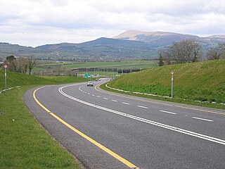
The M8 motorway is an inter-urban motorway in Ireland, which forms part of the motorway from the capital Dublin to Cork city. The 149 km motorway commences in the townland of Aghaboe, County Laois and runs through the counties of Kilkenny, Tipperary and Limerick, terminating at the Dunkettle interchange in Cork City. First called for in the Road Needs Study (1998), it was later incorporated into the National Development Plan (2000–2006) and later still formed part of the Irish Government's Transport 21 plan for infrastructural development. The majority of the M8 (115 km) was built between 2006 and 2010. On 28 May 2010, the motorway was completed and had replaced almost all of the single-carriageway N8 except for a short section of urban road in Cork City.

Skeheenarinky is a townland in south-west County Tipperary, Ireland. It is a dispersed settlement with a focal point at Skeheenarinky Cross where a school is located.

<span class="mw-page-title-main">Motorways in the Republic of Ireland</span>

In Ireland, the highest category of road is a motorway, indicated by the prefix M followed by a one- or two-digit number. The motorway network consists entirely of motorway-grade dual carriageways and is largely focused upon Dublin. There are also several three-lane motorways, while Ireland's busiest road, the M50, incorporates four-lane, five-lane, and six-lane stretches.

<span class="mw-page-title-main">R668 road (Ireland)</span> Road in Ireland

The R668 road is a regional road in Ireland from Lismore, County Waterford to Cahir in County Tipperary, through Clogheen and Ballylooby. The Lismore–Clogheen section is a scenic route through the Vee Gap in the Knockmealdown Mountains, between Sugarloaf Hill and Knockshanahullion.

<span class="mw-page-title-main">R670 road (Ireland)</span> Regional road in Ireland

The R670 road is a regional road in Ireland. The route runs from its junction with the R639 and N24 at Cloughabreeda 2 km north of Cahir through Cahir town and onwards for a further 8 km to Ardfinnan, where it joins the R665 road. The R670 is located entirely in County Tipperary.

References

  1. S.I. No. 54/2012 – Roads Act 1993 (Classification of Regional Roads) Order 2012 Irish Statute Book. 2012-02-28.
  2. For a detailed treatment of turnpike road construction in 18th-century Ireland, see David Broderick, The First Toll Roads: Ireland's Turnpike Roads, 1729-1858 (Cork, 2002).
  3. Herman Moll's New Map of Ireland (1714); see: http://www.swaen.com/zoom_map_large.htm?zoomifyImagePath=/os/zoom/02976/&zoomifyFadeInSpeed=10
  4. Taylor and Skinner's Maps of the Roads of Ireland (Dublin, 1778)
  5. J.H. Andrews, Shapes of Ireland : Maps and Their Makers, 1564-1839 (Dublin, 1997), p. 269
  6. Broderick, Ireland's Turnpike Roads, p. ii
  7. Quoted in Broderick, Ireland's Turnpike Roads, p. 106
  8. Andrews, Shapes of Ireland, p. 269
  9. Book (eISB), electronic Irish Statute. "electronic Irish Statute Book (eISB)". www.irishstatutebook.ie.
  10. "Archived copy" (PDF). Archived from the original (PDF) on 18 March 2009. Retrieved 9 March 2009.{{cite web}}: CS1 maint: archived copy as title (link)
  11. "Department of Transport: 2003". Archived from the original on 20 November 2007. Retrieved 2 January 2009.
  12. [ dead link ]