The N4 road is a national primary road in Ireland, running from Dublin to the northwest of Ireland and Sligo town. The M6 to Galway diverges from this route after Kinnegad, while the N5 to Westport diverges at Longford town. Most sections of the N4 that are motorway-standard are designated the M4 motorway.

The R293 road is a regional road in Ireland linking the N17, via a junction in the townland of Ballinabole near Collooney in County Sligo, to the outskirts of Ballyhaunis in County Mayo. En route it passes through three towns, Ballymote and Gorteen in County Sligo and Ballaghaderreen in County Roscommon. The road is 55 km (34 mi) long.

Ballygawley is a village in County Sligo, Ireland. It is located close to Union Wood and neighbouring town land Collooney and is situated approximately 9 km (5.6 mi) south of Sligo town and near the main Sligo-Dublin road, the N4. The Ó Dálaigh family, referenced in the town's Irish name, were professional poets active in Ireland during the Middle Ages.

The R284 road is a regional road in Ireland linking Sligo to Leitrim village in County Leitrim. En route it passes through Ballygawley, Ballyfarnan, Geevagh and Keadue. The road is 46 km (29 mi) long.

The Sligo Way is a long-distance trail mainly in County Sligo, Ireland. It is 78 kilometres long and begins in Larrigan, near Lough Talt and ends in Dromahair, County Leitrim. It is typically completed in three days. It is designated as a National Waymarked Trail by the National Trails Office of the Irish Sports Council and is managed by Sligo County Council, Sligo Integrated Development Company and the Sligo Walks Partnership.

The R286 road is a regional road in Ireland. It is largely a loop road from the N16 linking Sligo and north County Leitrim.

The R288 road is a regional road in Ireland. It connects the R287 and R286 roads in County Leitrim.

The R287 road is a regional road in Ireland linking Sligo and the R280 in County Leitrim.
The R289 road is a regional road in Ireland linking the R287 and the R280 in County Leitrim. The road is 5.9 km (3.7 mi) long.
The R298 road is a regional road in Ireland linking the R297 road near Enniscrone with the N59, entirely in County Sligo. The R298 is 4.9 km (3.0 mi) long.

The R231 road is a regional road in Ireland. It is a loop road from the N15 road in County Donegal. Most of the road is part of the Wild Atlantic Way.

The R341 road is a regional road in Ireland. It is a loop road from the N59 road in County Galway. South of the R342, the road is part of the Wild Atlantic Way.
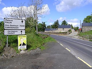
The R238 road is a regional road in Ireland. It is a ring road around the Inishowen Peninsula in County Donegal. The R238 is also part of the main road from Derry to Buncrana. Sections of the road form part of the Wild Atlantic Way. In July 2010, the road was the site of Ireland's worst road crash resulting in eight deaths.

The R241 road is a regional road in the north-west of Ireland. It is a coastal road on the eastern side of Inishowen, a peninsula in the north of County Donegal in Ulster. The road forms part of the Wild Atlantic Way. Part of the road is on the Inishowen Head Loop walking trail.

The R245 road is a regional road in Ireland. It is a loop road from the N56 road in County Donegal. Sections of the road form part of the Wild Atlantic Way.
The R261 road is a regional road in Ireland. It is a loop road from the N56 road on the Loughrea Peninsula in County Donegal. The road forms part of the Wild Atlantic Way.

The R482 road is a regional road in Ireland. It is a loop road from the N67 in County Clare. The road is part of the Wild Atlantic Way.

The R561 road is a regional road in Ireland. It is on the Dingle Peninsula in County Kerry. Part of the road is on the Wild Atlantic Way.

The R566 road is a regional road in Ireland. It is a road on the Iveragh Peninsula in County Kerry. Part of the road is on the Wild Atlantic Way.

The R591 road is a regional road in Ireland. It is a road on the Mizen Peninsula in County Cork. Most of the road forms part of the Wild Atlantic Way.