County Westmeath is a county in Ireland. It is in the province of Leinster and is part of the Midlands Region. It originally formed part of the historic Kingdom of Meath. It was named Mide because the kingdom was located in the geographical centre of Ireland. Westmeath County Council is the administrative body for the county, and the county town is Mullingar. At the 2016 census, the population of the county was 88,770.

Mullingar is the county town of County Westmeath in Ireland. It is the 3rd most populous town in the Midlands region, with a population of 20,928 in the 2016 census.

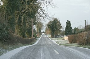
The N4 road is a national primary road in Ireland, running from Dublin to the northwest of Ireland and Sligo town. The M6 to Galway diverges from this route after Kinnegad, while the N5 to Westport diverges at Longford town. The section of the N4 that is motorway-standard is designated the M4 motorway.

A national secondary road is a category of road in Ireland. These roads form an important part of the national route network, but are secondary to the main arterial routes which are classified as national primary roads. National secondary roads are designated with route numbers higher than those used for primary roads, but with the same "N" prefix. Routes N51 and higher are all national secondary roads.
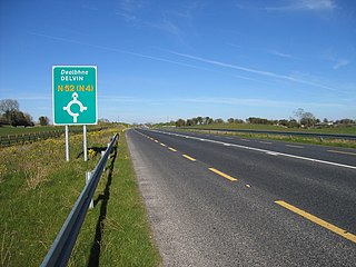
The N52 road is a national secondary road in Ireland. It links the M7 motorway from just south of Nenagh, County Tipperary to the M1 motorway north of Dundalk in County Louth. The route forms a connection between the north east of Ireland and the mid west traversing the midlands. It interchanges with the M6 at Kilbeggan and at Tyrrellspass, the N4 at Mullingar, the N3 at Kells, and the N2 at Ardee before continuing towards Dundalk.

Ardagh is a village in County Longford, Ireland about 10 km (6.21 mi) from Longford Town. It is located off the N4 road.

The R156 road is a regional road in Ireland, linking Dunboyne in County Meath to the N4 in County Westmeath. The road is single carriageway throughout. Many parts of the route have dangerous bends.

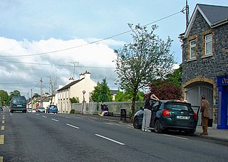
Crookedwood is a small village in County Westmeath on the R394 regional road. Historically it was called Taghmon, after the townland it occupies.
The R390 road is a regional road in Ireland linking Athlone to Mullingar, all of it within County Westmeath. It passes through the town of Ballymore, and several hamlets, before terminating in Mullingar.

The R400 road is a regional road in Ireland, linking Mullingar, County Westmeath to the R419 at Cushina, County Offaly.

The R394 road is a regional road in Ireland linking the N55 in County Cavan to Mullingar in County Westmeath. It passes through the town of Castlepollard and several villages and hamlets en route.
The R392 road is a regional road in Ireland linking Lanesborough, County Longford on the N63 to Mullingar, County Westmeath.

Rathconrath is a village in County Westmeath, Ireland. It is situated on the R392 regional road 12 km (7.5 mi) west of Mullingar.

The R393 road is a regional road in Ireland linking Longford to Mullingar in County Westmeath.

The Midland Regional Hospital, Mullingar is a public hospital at Mullingar in County Westmeath, Ireland. It is managed by Ireland East Hospital Group.
The Westmeath Way is a long-distance trail in County Westmeath, Ireland. It is 100 kilometres long and begins in Kilbeggan and ends in Athlone. It is typically completed in two days. It is designated as a National Waymarked Trail by the National Trails Office of the Irish Sports Council and is managed by Westmeath County Council and the Westmeath Way Committee. The trail forms part of the Dublin-Galway Greenway, part of the route 2 of the EuroVelo European cycle network.
Ballivor (pronounced:Bal-Eye-Ver) is a village in County Meath, Ireland. It had a population of 1,809 at the 2016 census. It is located on the R156 regional road between the towns of Mullingar and Trim.
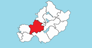
Rathconrath, previously the barony of Rathcomyrta, before that Daltons country, is a barony in the west of County Westmeath, in the Republic of Ireland. It was formed by 1542. It is bordered by County Longford to the north–west and five other Westmeath baronies: Moygoish to the north, Moyashel and Magheradernon to the east, Moycashel and Clonlonan to the south and Kilkenny West to the west. Note that the village of Rathconrath is not synonymous with the barony of the same name.

Clonlonan is a barony in south–west County Westmeath, Ireland. It was formed by 1672. It is bordered by County Offaly to the south and a small part of County Roscommon at Long Island on the River Shannon to the west. It also borders four other Westmeath baronies: Kilkenny West and Rathconrath, Moycashel and Brawny. The largest centre of population in the barony is the town of Moate.

Farbill is a barony in east County Westmeath, in the Republic of Ireland. It was formed by 1672. It is bordered by County Meath to the south and east and three other baronies: Fartullagh, Moyashel and Magheradernon and Delvin. The largest centre of population in the barony is the town of Kinnegad.