
The island of Ireland, comprising Northern Ireland and the Republic of Ireland, has an extensive network of tens of thousands of kilometres of public roads, usually surfaced. These roads have been developed and modernised over centuries, from trackways suitable only for walkers and horses, to surfaced roads including modern motorways. The major routes were established before Irish independence and consequently take little cognisance of the border other than a change of identification number and street furniture. Northern Ireland has had motorways since 1962, and has a well-developed network of primary, secondary and local routes. The Republic started work on its motorway network in the early 1980s; and historically, the road network there was once somewhat less well developed. However, the Celtic Tiger economic boom and an influx of European Union structural funding, saw national roads and regional roads in the Republic come up to international standard quite quickly. In the mid-1990s, for example, the Republic went from having only a few short sections of motorway to a network of motorways, dual carriageways and other improvements on most major routes as part of a National Development Plan. Road construction in Northern Ireland now tends to proceed at a slower pace than in the Republic, although a number of important bypasses and upgrades to dual carriageway have recently been completed or are about to begin.
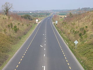
The N8 road is a national primary road in Ireland, connecting Cork with Dublin via the M7. The N8 is further classified by the United Nations as the entirety of the European route E 201, part of the trans-Europe International E-road network. The road is motorway standard from junction 19 on the M7 to the Dunkettle interchange in Cork City and is designated as the M8 motorway. From here the route continues into Cork city centre and terminates at the N22 road at St. Patrick's Street. The M8 motorway was completed in May 2010, replacing the single carriageway sections of the old N8 and bypassing towns on the main Cork to Dublin road. It is now possible to travel from Cork to Dublin on the M/N8 in about 2 hours 30 minutes. The route commences just south of Portlaoise, and reaches Cork via the midlands and the Golden Vale of Ireland, through Counties Laois, Kilkenny, Tipperary, Limerick and Cork.

The N81 road is a national secondary road in Ireland, from the M50 motorway to Tullow, County Carlow, north to south. The N81 continues past Tullow for another 8 km to terminate at the village of Closh, County Carlow, where it intersects the N80. The N81 is 76.784 km (47.711 mi) long. The road is a dual carriageway between M50 motorway and west of Tallaght, known as the Tallaght Bypass or Blessington Road. It intersects with the M50 motorway at Junction 11. There are plans to extend the dual carriageway by 5 km (3.1 mi) to the urban boundary.
The N9 road is a national primary road in Ireland running from Junction 11 on the M7, located near Kilcullen, County Kildare, to Waterford city. The route connects Dublin and Waterford. The section of the route from junction 11 on the M7 at Kilcullen to the intersection with the N24 road outside Waterford is motorway standard since 2010 and is designated as the M9 motorway. In line with Irish practice, all sections previously designated N9 were renumbered at that time. Only a short (550-metre) section of the route is still designated as N9 between the Quarry roundabout junction with the N24 and the N25 Grannagh Roundabout junction. This section is dual carriageway.

A regional road in the Republic of Ireland is a class of road not forming a major route, but nevertheless forming a link in the national route network. There are over 11,600 kilometres of regional roads. Regional roads are numbered with three-digit route numbers, prefixed by "R". The equivalent road category in Northern Ireland are B roads.

A national secondary road is a category of road in Ireland. These roads form an important part of the national route network but are secondary to the main arterial routes which are classified as national primary roads. National secondary roads are designated with route numbers higher than those used for primary roads, but with the same "N" prefix. Routes N51 and higher are all national secondary roads.
Ballickmoyler or Ballicmoyler is a small town in County Laois, Ireland. It lies 30 km (18.64 mi) southeast of Portlaoise, at the junction of the N80 national secondary road and the R429 regional road.

The R747 road is a regional road in Ireland running north-west/south-east from the M9 near Ballitore in County Kildare to Arklow in County Wicklow, a distance of 66 km (41 mi).

The R639 road is one of Ireland's regional roads. Once designated the N8 national primary road, it was reclassified in stages as the R639 following the progressive opening of sections of the M8 motorway, which rendered the single carriageway N8 redundant as a national primary road. By-passed sections of the old N8 were generally reclassified as R639 as soon as a new section of M8 opened, thereby increasing the length of the R639. With the completion of the M8 on 28 May 2010, the R639 now stretches from Durrow, County Laois to Cork, running through counties Laois, Kilkenny, Tipperary, Limerick and Cork.

The R726 road is a regional road in Ireland which runs west-east from the R417 in Carlow, County Carlow to the N81 near Rathvilly, County Carlow.

The R725 road is a regional road in Ireland. From its junction with the N80 on the western outskirts of Carlow Town it takes an easterly route to its junction with the N81 in Tullow, where it crosses the River Slaney on a bridge shared with the N80 in the town centre. It continues east to Shillelagh in County Wicklow, turns due south for 6 km, then eastwards through Carnew. It then enters County Wexford for the final 15 km stretch, terminating in Gorey at the R772. The road is 53 km (33 mi) long.

The N78 road is a national secondary road in Ireland. The 50-kilometer-long (31 mi) road links the N77 national secondary road north of Kilkenny, County Kilkenny to the M9 national primary route at Mullamast in County Kildare. En route it passes through the towns of Castlecomer in County Kilkenny, Ballylynan in County Laois, and Athy in County Kildare. It is single carriageway throughout.

The R418 road is a regional road in Ireland, which runs north-south from the R448 at Kilcullen to Athy, County Kildare, and then to the N81 in Tullow, County Carlow.

The R705 road is a regional road in Ireland which runs north-south from the R448 at Leighlinbridge in County Carlow and through Muine Bheag before crossing into County Kilkenny. It continues to Graiguenamanagh, passes Brandon Hill (516m) and continues south along the western side of the valley of the River Barrow until it terminates at a junction with the R700.
The R724 road is a regional road in County Carlow, Ireland. From its junction with the R448 at Royal Oak on the western edge of Muine Bheag Town it takes an easterly route crossing the River Barrow, the R705 regional road and the Dublin – Kilkenny railway line in the town.

The R702 road is a regional road in Ireland which runs west-east from the R712 at Coolgrange in County Kilkenny through Gowran before crossing into County Carlow at Goresbridge. It continues to Borris, passes through the Blackstairs Mountains via the Scullogue Gap into County Wexford and continues east until it terminates at a junction with the R890 in Enniscorthy.

The R430 road is a regional road in Ireland, which runs west-east from the R445 in Mountrath, County Laois to the R448 in Carlow, County Carlow. The route is 47 km (29 mi) long.

The R448 road is a regional road in Ireland. It is the designation given to the former N9 national primary road when it was bypassed by the M9 motorway.
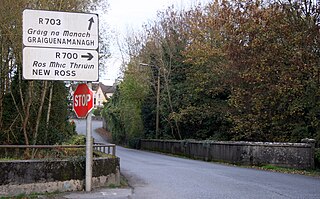
The R703 road is a regional road in Ireland which runs west-east from Thomastown in County Kilkenny through Graiguenamanagh before crossing into County Carlow and terminating at the R702 in Ballymurphy, County Carlow.

The R729 road is a regional road in County Carlow and County Wexford in Ireland. It connects the R702 near Borris to the R714 near New Ross, 22.1 km (13.7 mi) to the south.


