N25 road (Ireland)

Last updated

IRL N25.svg
N25 road
Bóthar N25
Route information
Part of E-01 euroroute IE.png E-30 euroroute IE.png
Length188.05 km (116.85 mi)
Location
Country Ireland
Primary
destinations
(bypassed routes in italics)
Highway system

The N25 road is a national primary road in Ireland, forming the route from Cork to Rosslare Europort via Waterford City. The road is part of the E30 European route and a short section is also part of the E01 European route. It forms part of the proposed Atlantic Corridor route. [1]

Contents

Route

Up to 22 February 2012, the Cork South Ring Road was designated as part of the N25. However, on 23 February, this section of road was redesignated as N40 and hence from this date, the N25 now commences at the Dunkettle Interchange. [2] From the Dunkettle Interchange the N25 commences east as the East Cork Parkway dual-carriageway, with interchanges for Fota Island and Cobh, and also Carrigtwohill. The next major destination on the route is Midleton.

N25 Waterford City bypass Suir RiverBridge looking south(Edit).jpg
N25 Waterford City bypass

The dual-carriageway ends after bypassing Midleton with an ordinary two-lane road continuing east to Youghal. At Youghal a single carriageway bypass was completed in 2003, bringing the road around the west of the town to the northern side of Youghal. Here the road crosses the River Blackwater into County Waterford. Northeast of this, the road was widened as part of the N25 Kinsalebeg project. This consisted of widening of 3.5 kilometers of single carriageway to include a hard shoulder on both sides of the road. The route passes Dungarvan, with a future bypass at preliminary design stage, [3] before meeting the N72 which makes its way to Killarney and County Kerry via Mallow, County Cork, Fermoy and Lismore, County Waterford. The N72 provides an alternative route to Kerry from and north of County Cork from Waterford and Wexford without going near Cork City and the Dunkettle Interchange. Then reaching Kilmeaden west of Waterford city and onto the bypass of the city itself. Beginning at Kilmeaden, it passes the Woodstown historic settlement before crossing the River Suir (via a cable stay bridge of about 475m in length) between Gracedieu in County Waterford and Grannagh in County Kilkenny. The bypass meets the M9 Motorway which leads to Dublin, Carlow, Kilkenny and Mullinavat and N24 which leads to Limerick, Tipperary, Cahir, Clonmel and Carrick On Suir at the Grannagh interchange, before joining the old N25 east of Slieverue. The bypass connects to the Outer Ring Road and the old N25 via a road known as the Western Link. (The bypass as a whole contains 23 km (14 mi) of dual carriageway* and 14 km (8.7 mi) of single carriageway.) The bypass is a tolled road. [4]

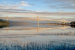
From Waterford, the N25 moves north to cross the River Barrow into County Wexford further up its estuary, bypassing New Ross over Ireland's longest bridge, the Rose Fitzgerald Kennedy Bridge, since 29 January 2020. [5] [6] The existing N25 into New Ross was redesignated as the R723 at that time. [7] East of the town, the N30 diverges and connects northeast to Enniscorthy,Clonroche and the M11 Dublin Wexford motorway. The N25 continues east to Wexford and meets the end of the N11 road which comes from Dublin and all the towns and villages including Enniscorthy at the New Ross Road Roundabout positioned west of the town. The N25 skirts the edge of the town around to the south and passes west of Tagoat and Rosslare to descend to reach Rosslare Harbour.

Rose Fitzgerald Kennedy Bridge, New Ross bypass Rose Fitzgerald Kennedy Bridge.jpg
Rose Fitzgerald Kennedy Bridge, New Ross bypass

Proposed developments

Some sections of the route have been proposed for upgrade to motorway standard. Part of the N25 dual carriageway in Midleton is to have all its junctions grade-separated and all direct accesses removed from the route (by the construction of a parallel road), thus making it suitable for upgrade to motorway status.[ citation needed ]

As of the early 21st century, TII was examining the possibility of a new road from Midleton to Youghal, with route options being investigated. [8] As part of the Atlantic Corridor road scheme, the section of road between Waterford and Rosslare Europort was proposed to be built as high quality dual carriageway or motorway standard. [9] In early 2022, it was announced that due to a funding shortfall, the portion from Carrigtwohill to Midleton would not be upgraded. [10]

Light aircraft crash

On 27 March 2017, a light aircraft crashed in a field adjacent to the road, killing the elderly pilot. It was one of three major aviation incidents involving Ireland in March 2017, with the Coastguard and Wales crash.

Junctions

N25 - Dunkettle to Midelton
WestboundJunctionEastbound
Dunkettle Interchange M8(Dublin), N40(Cork) Road continues as N8 J1Dunkettle Interchange M8(Dublin), N40(Cork) Start of dual carriageway
R623, Glounthaune, Little IslandJ2R623, Glounthaune, Little Island
R624, Cobh, Carrigtwohill J3R624, Cobh, Carrigtwohill
Carrigtwohill, Midleton J4Carrigtwohill, Midleton
MidletonJ5Midleton
Midleton, Whitegate Start of dual carriagewayLake view roundaboutMidleton, Whitegate End of dual carriageway

See also

Related Research Articles

<span class="mw-page-title-main">Roads in Ireland</span> Overview of roads in Ireland

The island of Ireland, comprising Northern Ireland and the Republic of Ireland, has an extensive network of tens of thousands of kilometres of public roads, usually surfaced. These roads have been developed and modernised over centuries, from trackways suitable only for walkers and horses, to surfaced roads including modern motorways. Driving is on the left-hand side of the road. The major routes were established before Irish independence and consequently take little cognisance of the border other than a change of identification number and street furniture. Northern Ireland has had motorways since 1962, and has a well-developed network of primary, secondary and local routes. The Republic started work on its motorway network in the early 1980s; and historically, the road network there was once somewhat less well developed. However, the Celtic Tiger economic boom and an influx of European Union structural funding, saw national roads and regional roads in the Republic come up to international standard quite quickly. In the mid-1990s, for example, the Republic went from having only a few short sections of motorway to a network of motorways, dual carriageways and other improvements on most major routes as part of a National Development Plan. Road construction in Northern Ireland now tends to proceed at a slower pace than in the Republic, although a number of important bypasses and upgrades to dual carriageway have recently been completed or are about to begin.

The N7 road is a national primary road in Ireland, connecting Limerick and Dublin. The majority of the route is motorway standard and is designated as the M7 motorway. At the Rosbrien interchange in Limerick the route continues as the N18 dual carriageway to Galway, Shannon and Ennis. The road passes through the midlands of Ireland, and acts as a trunk route out of Dublin for the N8 and N9 national primary routes to Cork and Waterford respectively. It forms part of European route E20.

<span class="mw-page-title-main">N11 road (Ireland)</span> National primary road in Ireland

The N11 road is a national primary road in Ireland, running for 129 km (80 mi) along the east side of Ireland from Dublin to Wexford. It passes close to Bray, Greystones, Wicklow, Arklow, Gorey, and Enniscorthy. Beyond Wexford, the route continues to Rosslare as the N25. The road forms part of European route E01. As of July 2019 the N11/M11 is of dual carriageway or motorway standard from Dublin as far as Oilgate in County Wexford.

<span class="mw-page-title-main">Rosslare Europort</span> Port in Rosslare Harbour, County Wexford, Ireland

Rosslare Europort is a modern seaport located at Rosslare Harbour in County Wexford, Ireland, near the southeasternmost point of the island of Ireland. The port is the primary Irish port serving the European Continent with 36 direct services to the Continent weekly. It handles passenger and freight ferries to and from Cherbourg, Dunkirk and St Malo/Roscoff, in France, Bilbao in Spain and Fishguard and Pembroke Dock in the United Kingdom. Since July 2022, a new freight route between Rosslare and Zeebrugge, Belgium was introduced by Finnlines for a twice weekly ro-ro service between the two ports.

<span class="mw-page-title-main">National Development Plan</span> Large infrastructure developments in Ireland

National Development Plan is the title given by the Irish Government to a scheme of organised large-scale expenditure on (mainly) national infrastructure. The first five-year plan ran from 1988 to 1993, the second was a six-year plan from 1994 to 1999 and the third ran as a seven-year plan from 2000 to 2006. A fourth National Development Plan ran from 2007 to 2011. The main elements of the third plan were the development of a national motorway network between the major cities in Ireland. The upgrading of the rail network was a secondary scheme.

<span class="mw-page-title-main">N9 road (Ireland)</span> Road in Ireland

The N9 road is a national primary road in Ireland running from Junction 11 on the M7, located near Kilcullen, County Kildare, to Waterford city. The route connects Dublin and Waterford. The section of the route from junction 11 on the M7 at Kilcullen to the intersection with the N24 road outside Waterford is motorway standard since 2010 and is designated as the M9 motorway. In line with Irish practice, all sections previously designated N9 were renumbered at that time. Only a short (550-metre) section of the route is still designated as N9 between the Quarry roundabout junction with the N24 and the N25 Grannagh Roundabout junction. This section is dual carriageway.

<span class="mw-page-title-main">Regional road (Ireland)</span> Class of road in Ireland

A regional road in the Republic of Ireland is a class of road not forming a major route, but nevertheless forming a link in the national route network. There are over 11,600 kilometres of regional roads. Regional roads are numbered with three-digit route numbers, prefixed by "R". The equivalent road category in Northern Ireland are B roads.

<span class="mw-page-title-main">N29 road (Ireland)</span> Road in Ireland

The N29 road is a national primary road in Ireland. It connects the Port of Waterford at Belview, County Kilkenny to Waterford City via the N25. The road and port are located on the north bank of the River Suir.

<span class="mw-page-title-main">N30 road (Ireland)</span> Road in Ireland

The N30 road is a national primary road in Ireland. It connects the N25 road and M11 motorway, providing a link running east-northeast through County Wexford, between New Ross and Enniscorthy. This provides for a more direct national route between the two towns, as the N25 and N11 both run to Wexford town, eastwards from New Ross and southwards from Enniscorthy respectively.

<span class="mw-page-title-main">N71 road (Ireland)</span> Road in Ireland

The N71 road is a national secondary road traversing counties Cork and Kerry in Ireland. Towns and villages along the route, westward from Cork city, include Innishannon, Bandon, Clonakilty, Skibbereen, Bantry and Glengarriff in County Cork. Continuing westwards from Glengarriff into County Kerry, the route passes Kenmare and terminates at Killarney.

<span class="mw-page-title-main">N72 road (Ireland)</span> Road in Ireland

The N72 road is a national secondary road in Ireland that runs east-west from its junction with the N25 near Dungarvan in County Waterford to the N70 in Killorglin in County Kerry.

<span class="mw-page-title-main">R710 road (Ireland)</span> Road in Ireland

The R710 road is a regional road in Ireland. Located in the south of Ireland at Waterford, it forms the Outer Ring Road around the south of the city. As of December 2006 it commences on the Old Kilmeaden Road at Knockhouse Lower, west of Waterford City and ends at a junction with the R683 on the Dunmore Road in the south-east of the city.

<span class="mw-page-title-main">European route E1</span> Road in trans-European E-road network

European route E1 is a series of roads in Europe, part of the United Nations International E-road network, running from Larne, Northern Ireland to Seville, Spain. There is a sea crossing between Rosslare Harbour, in Ireland, and Ferrol, but no ferry service. The road also passes through Portugal – past the city of Porto, through the capital, Lisbon, and then south to the Algarve, passing Faro before reaching the Spanish border west of Huelva.

<span class="mw-page-title-main">Atlantic Corridor</span> Proposed road project in Ireland

The Atlantic corridor or Atlantic motorway is a proposed road project in Ireland. The scheme, announced in 2005, was intended to link Waterford in the South-East to Letterkenny in the North-West via motorway or dual carriageway by 2015. However, in part due to the post-2008 Irish economic downturn, major sections of the roadway were delayed or cancelled.

<span class="mw-page-title-main">Kilmeadan</span> Village in County Waterford, Ireland

Kilmeadan or Kilmeaden is a village in County Waterford, Ireland. It is 10 km (6 mi) west of the centre of Waterford city on the R680 road.

<span class="mw-page-title-main">M8 motorway (Ireland)</span> Motorway in Ireland

The M8 motorway is an inter-urban motorway in Ireland, which forms part of the motorway from the capital Dublin to Cork city. The 149 km motorway commences in the townland of Aghaboe, County Laois and runs through the counties of Kilkenny, Tipperary and Limerick, terminating at the Dunkettle interchange in Cork City. First called for in the Road Needs Study (1998), it was later incorporated into the National Development Plan (2000–2006) and later still formed part of the Irish Government's Transport 21 plan for infrastructural development. The majority of the M8 (115 km) was built between 2006 and 2010. On 28 May 2010, the motorway was completed and had replaced almost all of the single-carriageway N8 except for a short section of urban road in Cork City.

<span class="mw-page-title-main">Motorways in the Republic of Ireland</span>

In Ireland, the highest category of road is a motorway, indicated by the prefix M followed by a one- or two-digit number. The motorway network consists entirely of motorway-grade dual carriageways and is largely focused upon Dublin. There are also several three-lane motorways, while Ireland's busiest road, the M50, incorporates four-lane, five-lane, and six-lane stretches.

This article deals with transport in Waterford city in Ireland. The city is connected by road, rail, bus, air and sea. There are currently proposals for a bus rapid transit system, consisting of bus trams, or streetcars, to be used in future.

<span class="mw-page-title-main">N40 road (Ireland)</span> National primary road in Cork City, Ireland

The N40 road is a national primary road in Cork City, Ireland. It is partial ring road skirting the southern suburbs of the city, from the N22 west of Ballincollig, via the Jack Lynch Tunnel under the River Lee, to the Dunkettle Interchange where it meets the N25 and N8/M8. The present N40 designation was created on 23 February 2012 via statutory instrument by renaming parts of the N22 and N25. The N40 serves as both a commuter route and a bypass of the city centre for traffic between parts southwest and east. The National Transport Strategy envisages building a "Cork North Ring Road" to complete the circuit in the 2030s.

References

  1. "Atlantic Corridor". Department of Transport. Archived from the original on 16 December 2008. Retrieved 5 January 2009.
  2. "Electronic Irish Statute Book (EISB)".
  3. "N25 Dungarvan Bypass". National Roads Authority . Retrieved 4 November 2014.
  4. "N25 Waterford Bypass - Toll Scheme". Waterford City Council . Retrieved 19 October 2009.
  5. Kane, Conor (29 January 2020). "N25 bypass with Ireland's longest bridge opens". RTÉ News . Retrieved 30 January 2020.
  6. "N25 New Ross Bypass". National Roads Authority . Retrieved 4 November 2014.
  7. "R723 - Roader's Digest: The SABRE Wiki". www.sabre-roads.org.uk.
  8. "N25 Midleton to Youghal". National Roads Authority . Retrieved 4 November 2014.
  9. "Transport 21 - N25 Rosslare to Waterford". Archived from the original on 9 April 2007.
  10. Griffin, Caitlín; O'Riordan, Sean (11 January 2022). "Shelving of multi-million euro upgrade of Cork road 'must be reversed'". Irish Examiner. Retrieved 18 March 2023.