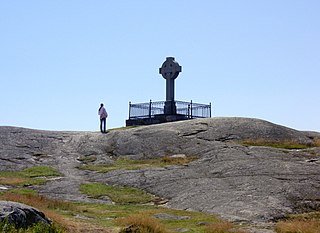
Birka, on the island of Björkö in present-day Sweden, was an important Viking Age trading center which handled goods from Scandinavia as well as many parts of the European continent and the Orient. Björkö is located in Lake Mälaren, 30 kilometers west of contemporary Stockholm, in the municipality of Ekerö.

County Waterford is a county in Ireland. It is in the province of Munster and is part of the Southern Region. It is named after the city of Waterford. Waterford City and County Council is the local authority for the county. The population of the county at large, including the city, was 127,085 according to the 2022 census. The county is based on the historic Gaelic territory of the Déise. There is an Irish-speaking area, Gaeltacht na nDéise, in the southwest of the county.

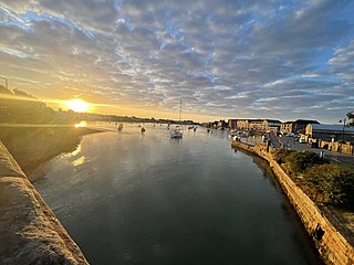
Waterford is a city in County Waterford in the south-east of Ireland. It is located within the province of Munster. The city is situated at the head of Waterford Harbour. It is the oldest and the fifth most populous city in the Republic of Ireland. It is the ninth most populous settlement on the island of Ireland. According to the 2022 census, 60,079 people live in the city, with a wider metropolitan population of 82,963.

Ringforts, ring forts or ring fortresses are circular fortified settlements that were mostly built during the Bronze Age up to about the year 1000. They are found in Northern Europe, especially in Ireland. There are also many in South Wales and in Cornwall, where they are called rounds. Ringforts come in many sizes and may be made of stone or earth. Earthen ringforts would have been marked by a circular rampart, often with a stakewall. Both stone and earthen ringforts would generally have had at least one building inside.

Kaupang was a Norse term for market-place composed of kaup- (buy) and angr, hence "buy fjord" or "buy harbor". Today, it is generally used as a name of the first town-like market-place in Norway, the Kaupang in Skiringssal, which is located in Tjølling near Larvik in Vestfold. Kaupang was an important merchant and craft center during the Viking period and as yet the first known Norwegian trading outpost.

Jarlshof is the best-known prehistoric archaeological site in Shetland, Scotland. It lies in Sumburgh, Mainland, Shetland and has been described as "one of the most remarkable archaeological sites ever excavated in the British Isles". It contains remains dating from 2500 BC up to the 17th century AD.

Grime's Graves is a large Neolithic flint mining complex in Norfolk, England. It lies 8 km (5.0 mi) north east from Brandon, Suffolk in the East of England. It was worked between c. 2600 and c. 2300 BC, although production may have continued through the Bronze and Iron Ages and later, owing to the low cost of flint compared with metals. Flint was much in demand for making polished stone axes in the Neolithic period. Much later, when flint had been replaced by metal tools, flint nodules were in demand for other uses, such as for building and as strikers for muskets.
Dungarvan is a coastal town and harbour in County Waterford, on the south-east coast of Ireland. Prior to the merger of Waterford County Council with Waterford City Council in 2014, Dungarvan was the county town and administrative centre of County Waterford. Waterford City and County Council retains administrative offices in the town. The town's Irish name means "Garbhann's fort", referring to Saint Garbhann who founded a church there in the seventh century.
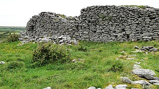
Cahercommaun, sometimes Cahercommane, is a triple stone ringfort on the south-east edge of the Burren area, in Kilnaboy, near the rural village of Carran, in County Clare, Ireland. It was built in the 9th century.

Lemybrien is a small village and townland in County Waterford, Ireland. It is on the N25 Cork to Waterford City road. Lemybrien is in the foothills of the Comeragh Mountains, in an area of County Waterford known as "The Déise". As of the 2016 census, the village had a population of 192 people, of whom 104 were male and 88 female.
A longphort is a term used in Ireland for a Viking ship enclosure or shore fortress. Although these longphorts were used as bases for Viking raids, the term had additional meanings and these sites had multiple purposes. The reason it cannot be assumed that longphorts were solely for military purposes as that would assume that there were always large numbers of Vikings at these settlements, which is not true. These camps were fortified areas along rivers, usually at a tributary where both sides were protected such that the Vikings could port ships. The sites were easily defended, sheltered, and gave immediate access to the sea. These camps would be of great importance to the Vikings during their raids of Ireland, which included attacks on many churches and monasteries located on the coast. It can be assumed that the purpose of these sites was to ease travel and trade within the region. Longphorts were essential to the economic prosperity of the Vikings. For example, it is clear that the earliest settlements became major trading centers throughout Ireland. Archeological evidence shows that imports and exports included textiles, animal skins, amber, and glass from England. During this time, the Vikings were able to begin a period of extremely profitable trade. Overall, the longphort settlements were essential in establishing the presence of the Vikings in Ireland during the ninth and tenth centuries.

Annagassan is a village in the townland of Ballynagassan, County Louth, Ireland. It sits where the River Glyde enters the Irish Sea.
Linn Duachaill is the name of a Viking longphort near the village of Annagassan, County Louth, Ireland. The settlement was built in 841 CE, the same time as the settlement of Dubh Linn, or Dublin. In contrast to Dublin, the settlement was abandoned. It has been argued that possibly because of changing tidal patterns, it lacked continuous access to the sea. The tides would have made access to the water difficult for a number of hours per day.

The First Viking Age in Ireland began in 795, when Vikings began carrying out hit-and-run raids on Gaelic Irish coastal settlements. Over the following decades the raiding parties became bigger and better organized; inland settlements were targeted as well as coastal ones; and the raiders built naval encampments known as longphorts to allow them to remain in Ireland throughout the winter. In the mid 9th century, Viking leader Turgeis or Thorgest founded a stronghold at Dublin, plundered Leinster and Meath, and raided other parts of Ireland. He was killed by the High King, Máel Sechnaill mac Máele Ruanaid, which was followed by several Irish victories against the Vikings and the seizure of Dublin in 849. Shortly after, a new group of Vikings known as the Dubgaill came to Ireland and clashed with the earlier Viking settlers, now called the Finngaill.

Fenor, officially Fennor, is a village in County Waterford, Ireland. The village itself is quite small, consisting almost entirely of the local school, pub, and parish church. It is on the R675 road around 5 km (3.1 mi) west of Tramore.
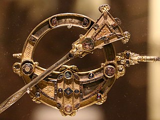
The Celtic brooch, more properly called the penannular brooch, and its closely related type, the pseudo-penannular brooch, are types of brooch clothes fasteners, often rather large; penannular means formed as an incomplete ring. They are especially associated with the beginning of the Early Medieval period in Ireland and Britain, although they are found in other times and places—for example, forming part of traditional female dress in areas in modern North Africa.
The archaeological sites Randlev and Hesselbjerg refer to two closely related excavations done throughout the 20th century near the village of Randlev in the Odder Municipality of Denmark, three kilometers southeast of the town of Odder. Randlev is known primarily for its Romanesque church constructed sometime around 1100 A.D. Hesselbjerg refers to the large Viking-Age cemetery discovered on the Hesselbjerg family farm and the site Randlev refers to the nearby settlement from the same period. Although both Randlev and Hesselbjerg were contemporaneous and encompass a similar area, Hesselbjerg refers more specifically to the 104 graves discovered prior to the later excavation at the site Randlev, which pertains to the Viking Age settlement. The settlement consisted of a farm complex that was likely active during the ninth and tenth centuries; finds from the site such as silver hoards and elaborate jewelry indicate that the farm was likely prosperous, a conjecture which is supported by the extremely fertile land surrounding the area. Artifacts were found in the vicinity of the Hesselbjerg and Randlev sites as early as 1932 when a local farmer discovered a silver hoard, but serious excavations were not conducted until 1963. These excavations ended in 1970; however, Moesgård Museum returned to the site in 1997 and continued analysis until 2010.
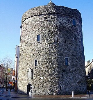
Reginald's Tower is a historic tower in Waterford, Munster, Ireland. It is located at the eastern end of the city quay. The tower has been in usage for different purposes for many centuries and is an important landmark in Waterford and an important remnant of its medieval urban defence system. It is the oldest civic building in Ireland and it is the only urban monument in Ireland to retain a Norse or Viking name.
While the Vikings are perhaps best known for accumulating wealth by plunder, tribute, and conquest, they were also skilled and successful traders. The Vikings developed several trading centres both in Scandinavia and abroad as well as a series of long-distance trading routes during the Viking Age. Viking trading centres and trade routes would bring tremendous wealth and plenty of exotic goods such as Arab coins, Chinese Silks, and Indian Gems. Vikings also established a "bullion economy" in which weighed silver, and to a lesser extent gold, was used as a means of exchange. Evidence for the centrality of trade and economy can be found in the criminal archaeological record through evidence of theft, counterfeit coins, and smuggling. The Viking economy and trade network also effectively helped rebuild the European economy after the fall of the Roman Empire
Tønnesminde is the site of an archaeological excavation ground and present day organic farm on the island of Samsø, Denmark. Archaeological evidence attests the area around Tønnesminde has a long history of human occupation, dating from approximately 4000 BC to present day. Recent excavations suggest that Tønnesminde contains settlements dating from the Funnelbeaker culture in the Early Neolithic period, Early Bronze Age, Pre-Roman Iron Age, and Viking Age.
