
County Waterford is a county in Ireland. It is in the province of Munster and is part of the Southern Region. It is named after the city of Waterford. Waterford City and County Council is the local authority for the county. The population of the county at large, including the city, was 127,363 according to the 2022 census. The county is based on the historic Gaelic territory of the Déise. There is an Irish-speaking area, Gaeltacht na nDéise, in the southwest of the county.

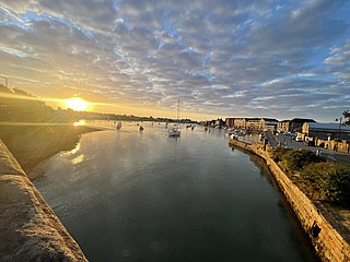
Waterford is a city in County Waterford in the south-east of Ireland. It is located within the province of Munster. The city is situated at the head of Waterford Harbour. It is the oldest and the fifth most populous city in the Republic of Ireland. It is the ninth most populous settlement on the island of Ireland. As of the 2022 census, 60,079 people lived in the city and its suburbs.

The Barrow is a river in Ireland. It is one of The Three Sisters; the other two being the River Suir and the River Nore. The Barrow is the longest of the three rivers and, at 192 km (120 mi), the second-longest river in Ireland, behind the River Shannon. The catchment area of the River Barrow is 3,067 km2 before the River Nore joins it a little over 20 km before its mouth. The river's long term average flow rate, again before it is joined by River Nore, is 37.4 cubic metres per second. At the merger with the River Nore, its catchment area is ca. 5,500 km2 and its discharge over 80 m3/s.
Dungarvan is a coastal town and harbour in County Waterford, on the south-east coast of Ireland. Prior to the merger of Waterford County Council with Waterford City Council in 2014, Dungarvan was the county town and administrative centre of County Waterford. Waterford City and County Council retains administrative offices in the town. The town is in a townland and civil parish of the same name.

The River Suir is a river in Ireland that flows into the Atlantic Ocean through Waterford after a distance of 185 kilometres (115 mi). The catchment area of the Suir is 3,610 km2. Its long-term average flow rate is 76.9 cubic metres per second (m3/s), about twice the flow of either the River Barrow or the River Nore before these join, but a little less than the Barrow's flow when it meets the Suir 20 km downstream.

The River Nore is one of the principal rivers in the South-East Region of Ireland. The 140-kilometre-long (87 mi) river drains approximately 2,530 square kilometres (977 sq mi) of Leinster and Munster, that encompasses parts of three counties. Along with the River Suir and River Barrow, it is one of the constituent rivers of the group known as the Three Sisters.

Wexford Harbour in County Wexford, Ireland is the natural harbour at the mouth of the River Slaney. In earlier times, the area occupied by the harbour was considerably larger than it is today, up to ten miles (16 km) wide at its widest point, with large mud flats on both sides. These were known as the North Slob and the South Slob from the Irish word slab, meaning mud. It contained several islands, among which the large island of Beggerin was known to be a safe refuge for early Christian settlements.

The River Slaney is a large river in the southeast of Ireland. It rises on Lugnaquilla Mountain in the western Wicklow Mountains and flows west and then south through counties Wicklow, Carlow and Wexford for 117.5 km (73 mi), before entering St George's Channel in the Irish Sea at Wexford town. The estuary of the Slaney is wide and shallow and is known as Wexford Harbour. The catchment area of the River Slaney is 1,762 km2. The long-term average flow rate of the River Slaney is 37.4m3/s

The Hook Peninsula is a peninsula in County Wexford, Ireland. It has been a gateway to south-east Ireland for successive waves of invaders, including the Vikings, Anglo-Normans and the English.

Dingle Bay is a bay located in County Kerry, western Ireland. The outer parts of the Dingle Peninsula and Dingle Bay mark one of the westernmost points of mainland Ireland. The harbour town of Dingle lies on the north side of the bay.

District of Shelburne, officially named the Municipality of the District of Shelburne, is a district municipality comprising the eastern section of Shelburne County, Nova Scotia, Canada, but does not include the Towns of Shelburne or Lockeport. Statistics Canada classifies the district municipality as a municipal district. It is home to the Bowers Meadows Wilderness Area.

Creadan Head is a headland on a small peninsula on the west side of Waterford Harbour, about three miles upriver from Dunmore East, in County Waterford, Ireland.

The Hook Lighthouse is a building situated on Hook Head at the tip of the Hook Peninsula in County Wexford, in Ireland. It is one of the oldest lighthouses in the world and the second oldest operating lighthouse in the world, after the Tower of Hercules in Spain. It is operated by the Commissioners of Irish Lights, the Irish lighthouse authority, and marks the eastern entrance to Waterford Harbour. The current structure has stood for over 800 years.

Tralee Bay is located in on the west coast of County Kerry, Ireland. It is situated between Kerry Head on the north side and the Maharees on the west and extends eastwards as far as the bridge at Blennerville. Several small rivers feed into the bay through the town of Tralee. Villages around the bay include; Ballyheigue, Fenit, Kilfinora, Spa, Blennerville, Camp and Castlegregory.
Royal Oak is a small village in County Carlow, Ireland. It is on the west side of the River Barrow, across from Bagenalstown, and is off the former N9 road. It is not in or a part of Bagenalstown.
Kilrush Marina is a locked marina in Kilrush Harbour, Kilrush, County Clare, Ireland. It has a well equipped marina services building, with an extensive boatyard, including a large indoor boat storage and repair facility. Many boats from other leisure boating centres on the West Coast of Ireland winter in Kilrush. Originally funded by Shannon Development the marina has grown to be an integral part of the local economy. The marina is used as a base for day trips to Scattery Island and for Dolphin Watch cruises.

The borders of the oceans are the limits of Earth's oceanic waters. The definition and number of oceans can vary depending on the adopted criteria. The principal divisions of the five oceans are the Pacific Ocean, Atlantic Ocean, Indian Ocean, Southern (Antarctic) Ocean, and Arctic Ocean. Smaller regions of the oceans are called seas, gulfs, bays, straits, and other terms. Geologically, an ocean is an area of oceanic crust covered by water.

Clonmines is a civil parish and townland in the Bannow Bay area of County Wexford, Ireland, the site of "the finest example in Ireland of a deserted medieval borough". It is situated in the barony of Shelburne, southwest of Wellingtonbridge on the northwest shore of Bannow Bay. The parish of Clonmines contains the townland of the same name and the smaller townland of Arklow, with respective areas of 1,258 acres (509 ha) and 127 acres (51 ha).
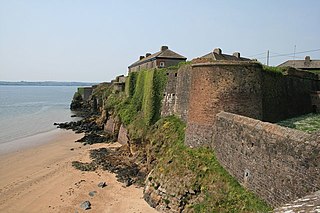
Duncannon Fort is a star fort and National Monument located in County Wexford, Ireland.
The Cloch Labhrais, also called the Answering Stone and the Speaking Stone, is a large glacial erratic boulder beside a road leading from Waterford to Dungarvan, 2 miles (3 km) from Stradbally, County Waterford in Ireland. The stone is the subject of a legend, much like the Blarney Stone. The most prominent and unique feature of the stone is a large, 5-foot-wide split (1.5 m) almost completely cleaving the stone in two. The large glacial boulder likely obtained the split when the glacial ice melted due to a rapid temperature change between the ice and the water of the stream.
