
Waterford is a city in County Waterford in the south-east of Ireland. It is located within the province of Munster. The city is situated at the head of Waterford Harbour. It is the oldest and the fifth most populous city in Ireland. It is the ninth most populous settlement on the island of Ireland. Waterford City and County Council is the local government authority for the city. According to the 2016 Census, 53,504 people live in the city, with a wider metropolitan population of 82,963.

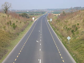
The island of Ireland, comprising Northern Ireland and the Republic of Ireland, has an extensive network of tens of thousands of kilometres of public roads, usually surfaced. These roads have been developed and modernised over centuries, from trackways suitable only for walkers and horses, to surfaced roads including modern motorways. Driving is on the left-hand side of the road. The major routes were established before Irish independence and consequently take little cognisance of the border other than a change of identification number and street furniture. Northern Ireland has had motorways since 1962, and has a well-developed network of primary, secondary and local routes. The Republic started work on its motorway network in the early 1980s; and historically, the road network there was once somewhat less well developed. However, the Celtic Tiger economic boom and an influx of European Union structural funding, saw national roads and regional roads in the Republic come up to international standard quite quickly. In the mid-1990s, for example, the Republic went from having only a few short sections of motorway to a network of motorways, dual carriageways and other improvements on most major routes as part of a National Development Plan. Road construction in Northern Ireland now tends to proceed at a slower pace than in the Republic, although a number of important bypasses and upgrades to dual carriageway have recently been completed or are about to begin.

New Ross is a town in southwest County Wexford, Ireland. It is located on the River Barrow, near the border with County Kilkenny, and is around 20 kilometres (12 mi) northeast of Waterford. In 2016 it had a population of 8,040 people, making it the fourth-largest town in the county.

Rail transport in Ireland is provided by Iarnród Éireann in the Republic of Ireland and by Northern Ireland Railways in Northern Ireland.

National Development Plan was the title given by the Irish Government to a scheme of organised large-scale expenditure on (mainly) national infrastructure. The first five-year plan ran from 1988 to 1993, the second was a six-year plan from 1994 to 1999 and the third ran as a seven-year plan from 2000 to 2006. A fourth National Development Plan ran from 2007 to 2011. The main elements of the third plan were the development of a national motorway network between the major cities in Ireland. The upgrading of the rail network was a secondary scheme.
The N9 road is a national primary road in Ireland running from Junction 11 on the M7, located near Kilcullen, County Kildare, to Waterford city. The route connects Dublin and Waterford. The section of the route from junction 11 on the M7 at Kilcullen to the intersection with the N24 road outside Waterford is motorway standard since 2010 and is designated as the M9 motorway. In line with Irish practice, all sections previously designated N9 were renumbered at that time. Only a short (550-metre) section of the route is still designated as N9 between the Quarry roundabout junction with the N24 and the N25 Grannagh Roundabout junction. This section is dual carriageway.
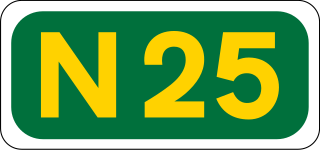
The N25 road is a national primary road in Ireland, forming the route from Cork to Rosslare Europort via Waterford City. The road is part of the E30 European route and a short section is also part of the E01 European route. It forms part of the proposed Atlantic Corridor route.

A national primary road is a road classification in Ireland. National primary roads form the major routes between the major urban centres. There are 2649 km of national primary roads. This category of road has the prefix "N" followed by one or two digits. Motorways are prefixed "M" followed by one or two digits.

The N72 road is a national secondary road in Ireland that runs east-west from its junction with the N25 near Dungarvan in County Waterford to the N70 in Killorglin in County Kerry.

The R710 road is a regional road in Ireland. Located in the south of Ireland at Waterford, it forms the Outer Ring Road around the south of the city. As of December 2006 it commences on the Old Kilmeaden Road at Knockhouse Lower, west of Waterford City and ends at a junction with the R683 on the Dunmore Road in the south-east of the city.

Rosslare Strand railway station is in Rosslare Strand, County Wexford, Ireland. It is the junction of the Dublin–Rosslare railway line and the Limerick–Rosslare railway line, the Rosslare Strand to Waterford section of which is mothballed.
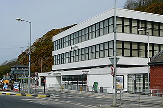
Waterford railway station serves the city of Waterford in County Waterford, Ireland. The station is located across Rice Bridge on the north side of the city.

The R683 road is a regional road in County Waterford, Ireland. It connects Waterford city to the village and ferry port of Passage East. The ferry operates across the River Barrow estuary to the village of Ballyhack, County Wexford.

The R448 road is a regional road in Ireland. It is the designation given to the former N9 national primary road when it was bypassed by the M9 motorway.
When formed in 1945, Córas Iompair Éireann (CIÉ) inherited a GSR wagon fleet insufficient for post-war requirements. A major wagon building programme in the 1950s and 1960s eliminated this pre-war stock. The new stock consisted of open or covered general purpose wagons of the four-wheel loose-coupled design, without vacuum brakes and limited to 35mph. There were also a few specialised wagons built for tar, grain and cattle.
This article deals with transport in Waterford city in Ireland. The city is connected by road, rail, bus, air and sea. There are currently proposals for a bus rapid transit (BRT) system, consisting of bus trams, or streetcars, to be used in future.

Clerihan or Ballyclerahan is a village in County Tipperary, Ireland. It is also a civil parish in the barony of Iffa and Offa East. It is approximately 8.5 kilometres north of Clonmel. Its name comes from the Irish meaning O'Clerahan's town. Locally, the "Bally" prefix is usually dropped and the village is almost always referred to simply as "Clerahan" which is most often spelled "Clerihan".

The R676 road is a regional road in Ireland. It connects the N25 road in County Waterford to the N24 at Carrick-on-Suir, County Tipperary, via the villages of Mahon Bridge and Carrickbeg. The road is 23.9 kilometres (14.9 mi) long.
The R634 road is a regional road in Ireland. It travels from the N25 road outside Youghal, County Cork, north to the N72 in County Waterford, via Youghal town centre and the village of Tallow, County Waterford. The road is 28.8 kilometres (17.9 mi) long.

The R671 road is a regional road in Ireland. It travels from Clonmel, County Tipperary to the N25 road in County Waterford, via the villages of Ballymacarbry and Clashmore. It follows the route of the former national trunk road T27. The road is 55.4 kilometres (34.4 mi) long.
