
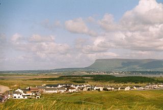
County Sligo is a county in Ireland. It is located in the Border Region and is part of the province of Connacht. Sligo is the administrative capital and largest town in the county. Sligo County Council is the local authority for the county. The population of the county was 65,535 at the 2016 census. It is noted for Benbulben Mountain, one of Ireland's most distinctive natural landmarks.

The island of Ireland, comprising Northern Ireland and the Republic of Ireland, has an extensive network of tens of thousands of kilometres of public roads, usually surfaced. These roads have been developed and modernised over centuries, from trackways suitable only for walkers and horses, to surfaced roads including modern motorways. Driving is on the left-hand side of the road. The major routes were established before Irish independence and consequently take little cognisance of the border other than a change of identification number and street furniture. Northern Ireland has had motorways since 1962, and has a well-developed network of primary, secondary and local routes. The Republic started work on its motorway network in the early 1980s; and historically, the road network there was once somewhat less well developed. However, the Celtic Tiger economic boom and an influx of European Union structural funding, saw national roads and regional roads in the Republic come up to international standard quite quickly. In the mid-1990s, for example, the Republic went from having only a few short sections of motorway to a network of motorways, dual carriageways and other improvements on most major routes as part of a National Development Plan. Road construction in Northern Ireland now tends to proceed at a slower pace than in the Republic, although a number of important bypasses and upgrades to dual carriageway have recently been completed or are about to begin.
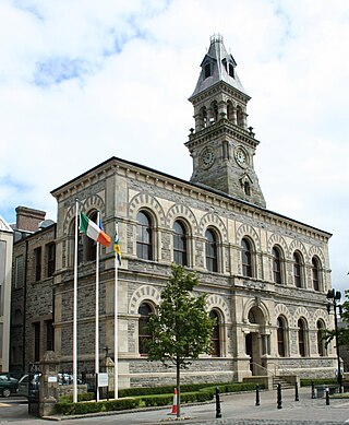
Sligo is a coastal seaport and the county town of County Sligo, Ireland, within the western province of Connacht. With a population of approximately 20,000 in 2016, it is the largest urban centre in the county, with Sligo Borough District constituting 61% (38,581) of the county's population of 63,000.

The N4 road is a national primary road in Ireland, running from Dublin to the northwest of Ireland and Sligo town. The M6 to Galway diverges from this route after Kinnegad, while the N5 to Westport diverges at Longford town. Most sections of the N4 that are motorway-standard are designated the M4 motorway.

Sligo Airport is located in Strandhill, County Sligo, 5 NM west of Sligo, at the end of the R277 road, in Ireland. The airport is a small regional airport and has no scheduled routes.

The N17 road is a national primary road in Ireland, and is part of the Atlantic Corridor route. It begins in County Galway and ends in County Sligo. On 27 September 2017 the southern, Tuam–Galway, section was upgraded to motorway status and designated M17.

Ballysadare, locally also Ballisodare, is a town in County Sligo, Ireland. It is about 7 kilometres south of Sligo town. The town developed on an important crossing of the Owenmore River.

Collooney or Coloony is a town in County Sligo, Ireland.

Knocknahur, also known as Ransboro, is a village in County Sligo, Ireland.

Rosses Point is a village in County Sligo, Ireland and also the name of the surrounding peninsula.
Strandhill or occasionally Larass is a coastal town and townland on the Coolera Peninsula in County Sligo, Ireland. As of 2016, the population was 1,753, an increase of 10% from the 2011 Census. The old name appears to be Ros Dragnige.

A regional road in the Republic of Ireland is a class of road not forming a major route, but nevertheless forming a link in the national route network. There are over 11,600 kilometres of regional roads. Regional roads are numbered with three-digit route numbers, prefixed by "R". The equivalent road category in Northern Ireland are B roads.
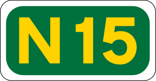
The N15 road is a national primary road in the north-west of Ireland. It runs from Sligo to Lifford, County Donegal. It forms part of the proposed Atlantic Corridor route. It also goes to the border with Northern Ireland.

The N59 road is a national secondary road in Ireland. It commences in County Sligo, south of Sligo Town at the Belladrehid interchange with the N4 north of Ballysadare. The route circles around the west of Ireland, passing west from Sligo into County Mayo and through Ballina. The N59 continues around Mayo, proceeding indirectly to Westport. Continuing south through Mayo into County Galway, the road passes through the village of Leenaun. The 182-year-old bridge in the centre of the village, carrying the road across the River Lahill, collapsed in floods on 18 July 2007. Due to the local terrain and road network, the diversionary route for getting from the south of the village to Westport was 110 km long. A temporary bridge was opened eight days after the floods, on 27 July. It has since been replaced by a new bridge.

The N87 road is a national secondary road in the north of County Cavan, Ireland.

The R291 road is a regional road in Ireland linking Sligo and Rosses Point in County Sligo. The road is part of the Wild Atlantic Way.
The R277 road is a regional road in Ireland linking the R292 road from just outside Strandhill to Sligo Airport (Strandhill) in County Sligo. The airport access section of the road, Airport Road, is the site of the Sligo Airport Business Park, a technology and enterprise centre hosting 17 companies.

The R290 road is a regional road in Ireland linking the R287 and the N59 in County Sligo.

The Ballisodare River is a river in Ireland, flowing through County Sligo.

The Coolera Peninsula is a peninsula in Sligo Bay, County Sligo, Ireland. It is the most populous of County Sligo's peninsulas, and the second-largest by land area. The primary population centres on Coolera are the coastal town of Strandhill on its western shore, and Magheraboy, a suburb of Sligo town.

