
Dundalk, meaning "the fort of Dealgan", is the county town of County Louth, Ireland. The town is on the Castletown River, which flows into Dundalk Bay on the east coast of Ireland. It is halfway between Dublin and Belfast, close to the border with Northern Ireland. It is the eighth largest urban area in Ireland, with a population of 39,004 as of the 2016 census.
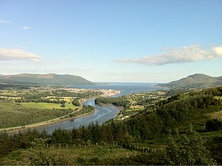
Carlingford Lough is a glacial fjord or sea inlet in northeastern Ireland, forming part of the border between Northern Ireland to the north and the Republic of Ireland to the south. On its northern shore is County Down, the Mourne Mountains, and the town of Warrenpoint; on its southern shore is County Louth, the Cooley Mountains and the village of Carlingford. The Newry River flows into the loch from the northwest.

Greenore is a village, townland and deep water port on Carlingford Lough in County Louth, Ireland.
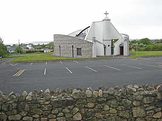
Jenkinstown is a village and townland in the Municipal District of Dundalk, County Louth, Ireland on the Cooley Peninsula.

Carlingford is a coastal town and civil parish in northern County Louth, Ireland. For the purposes of local government, the town is part of the Dundalk Municipal District. It is situated on the southern shore of Carlingford Lough with Slieve Foy mountain as a backdrop, sometimes known as Carlingford Mountain. It is the main town on the Cooley Peninsula. Located on the R176/R173 roads between Greenore and Omeath village, Carlingford is approximately 27 km north east from Dundalk, 90 km north of Dublin and 11 km south of the border with Northern Ireland. Carlingford won the Irish Tidy Towns Competition in 1988.

The R178 road is a regional road in Ireland. It runs from Dundalk, County Louth via Carrickmacross, County Monaghan and Shercock to Virginia, County Cavan.
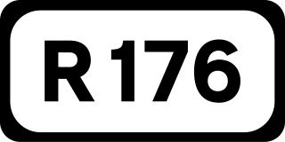
The R176 road is a regional road in Ireland, running its full length on the Cooley Peninsula in County Louth. It runs between its junction with R173 at Ghan Road, Carlingford and its junction with R175 at Saint James' Well via Carlingford Relief Road and Mullatee.
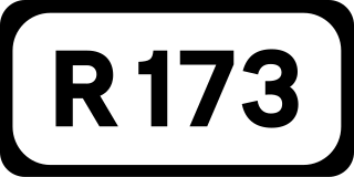
The R173 road is a regional road in Ireland, running its full length in County Louth. It loops around Cooley Peninsula, mainly along the coast. It nearly encircles the Cooley Mountains.

Omeath is a village on the Cooley Peninsula in County Louth, Ireland, close to the border with Northern Ireland. It is roughly midway between Dublin and Belfast, very near the County Louth and County Armagh / County Down border. As of the 2016 census, Omeath had a population of 603, up from 439 during the 2006 census. It is approximately 6 km (3.7 mi) from Carlingford and about 8 km (5.0 mi) from Newry. By sea, Omeath's nearest land neighbour is Warrenpoint on the south County Down coast.
The R132 road is one of Ireland's newest regional roads, having been classified following the opening M1 motorway which by-passes most of the old N1 route. The R132 is 98.9 kilometres (61.5 mi) long.

The Cooley Peninsula is a hilly peninsula in the north of County Louth on the east coast of Ireland; the peninsula includes the small town of Carlingford, the port of Greenore and the village of Omeath.
The R108 road is a regional road in Ireland, linking Drogheda in County Louth to Christchurch Place, Dublin.

The R165 road is a regional road in Ireland, linking the R188 5 km (3.1 mi) west of Cootehill in County Cavan to the N2 near Ardee, County Louth.

The N53 road is a national secondary road in Ireland, running from junction 17 of the M1 just outside Dundalk, County Louth to the N2 bypass of Castleblayney, County Monaghan.

The R152 road is a regional road in Ireland, linking the N2 in County Meath to Drogheda in County Louth via the town of Duleek.

The R169 road is a regional road in Ireland linking Mollyrue and Dunleer in County Louth.

The R170 road is a regional road in Ireland linking Ardee and Murray's Cross in County Louth. The road passes through the town of Dunleer and the village of Grangebellew.

The R177 road is a regional road in Ireland linking Lisdoo and the Border with Northern Ireland in County Louth. The road continues as the A29 across the border in Northern Ireland. The road is 5.5 km (3.4 mi) long.
The R215 road is a regional road in Ireland which links Ardee with Dundalk in County Louth. The road was originally a section of the N52, however it was downgraded to ease traffic and encourage use of the nearby M1 motorway. Signage on the road have yet to reflect the change.

The R934 road is a regional road in Ireland which links the M1 motorway with the R132 regional road in Dundalk in County Louth.

