
The Grand Canal is the southernmost of a pair of canals that connect Dublin, in the east of Ireland, with the River Shannon in the west, via Tullamore and a number of other villages and towns, the two canals nearly encircling Dublin's inner city. Its sister canal on the Northside of Dublin is the Royal Canal. The last working cargo barge passed through the Grand Canal in 1960.

Monasterevin, sometimes Monasterevan, is a town in County Kildare, Ireland. It lies on the River Barrow and the Barrowline, a canal branch of the Grand Canal. In the 20 years between the 2002 and 2022 censuses, the population more than doubled, from 2,583 to 5,307 inhabitants. The town is in a townland and civil parish of the same name.

The R445 road is a regional road in Ireland. The route is a non-motorway alternative route to the N7/M7 motorway between Naas and Limerick, and at 170 km it is one of the longest regional roads in Ireland. Indeed, much of the route comprises roads that were formerly part of the N7 between the cities, prior to motorway and other bypasses. Some of the R445 route also comprises local link roads to new N7/M7 route sections.

Edenderry is a town in east County Offaly, Ireland. It is near the borders with Counties Kildare, Meath and Westmeath. The Grand Canal runs along the south of Edenderry, through the Bog of Allen, and there is a short spur to the town centre.
The kingdom of Uí Fháilghe, Uí Failge or Uíbh Fhailí, was a Gaelic-Irish kingdom which existed to 1550, the name of which is preserved in the name of County Offaly, Ireland.

Rathangan is a town in the west of County Kildare, Ireland. As of 2022, the population was 3,263. It is located 65 km (40 mi) from the centre of Dublin, and 14 km (8.7 mi) from Kildare, at the intersection of the R401, R414, and R419 regional roads. The Slate River and the Grand Canal run through the town. The town is in a townland and civil parish of the same name.

Rhode is a village in County Offaly, Ireland. It is situated on the R400 at its junction with the R441 which leads to Edenderry, 12 km to the east. Rhode village is on an "island" of high ground surrounded by an expanse of raised bog which forms part of the Bog of Allen.

Lullymore is a civil parish and village in County Kildare, Ireland. It is in the historical barony of Offaly East. The lowest observed 20th century air temperature in Ireland, -18.8 °C was measured at Lullymore on 2 January 1979.
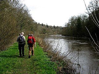
The Barrow Way is a long-distance trail in Ireland. It is 100 kilometres long and begins in Robertstown, County Kildare and ends in St Mullin's, County Carlow, following the course of the River Barrow and the Barrow Line of the Grand Canal through counties Kildare, Carlow, Kilkenny and Laois. It is typically completed in four days. It is designated as a National Waymarked Trail by the National Trails Office of the Irish Sports Council and is managed by Waterways Ireland.

The Little Brosna River rises near Dunkerrin, County Offaly, Ireland. It flows for 36 miles before joining the River Shannon.
The Ballyfinboy River rises close to Moneygall in County Offaly, Ireland and flows in a generally northwesterly direction into Lough Derg at Drominagh. It forms part of the boundary between County Tipperary and County Offaly. The river flows through the towns of Cloughjordan and Borrisokane west of which it flows past Ballyfinboy Castle, a ruined tower house with a Sheela na gig in the townland of Ballyfinboy.
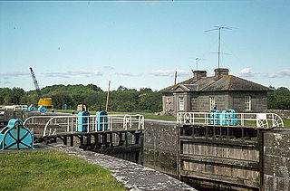
Victoria Lock, also known as Meelick Lock, is the first lock on the River Shannon upstream of Lough Derg, it is situated between Meelick, County Galway and Clonahenoge, County Offaly where the Little Brosna River enters the Shannon. It is very near the tripoint where the provinces of Munster, Leinster and Connacht meet. The lock is of architectural and technical interest and is listed on the Nation Inventory of Architectural Heritage, the dimensions are 142 ft x 40 ft. Thomas Rhodes on the instructions of the Shannon Commissioners constructed the lock in the 1840s as part of a widescale upgrade of the Shannon Navigation. The lock is still in use today by pleasure craft, both private and fleets of rental cruisers who use the River Shannon and the connecting canals. A second lock, Hamilton Lock is also located nearby but is now disused.
Clonahenoge is a townland in County Offaly, Ireland. It is located at the confluence of the Little Brosna River and the River Shannon.
Sharavogue is a townland in the historical Barony of Clonlisk, County Offaly, Ireland. It is a rural area located near the junction of the N52 road and the R492 between Roscrea and Birr. The Little Brosna River flows under Sharavogue bridge.
The Morell River is a river in County Kildare, Ireland, a tributary of the River Liffey.
The Figile River is a river in eastern Ireland.
The Painestown River is a river in County Kildare, Ireland, a tributary of the Morell River.
The Yellow River is a river in central Ireland, a tributary of the River Boyne.
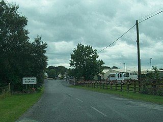
Belmont is a village in County Offaly, Ireland.

Painswick Stream is a small river in Gloucestershire, England. It is a tributary of the River Frome, and flows generally southwards, passing around the village of Painswick and through the town of Stroud. It used to join the Frome at its mouth, but was diverted into the then-derelict Stroudwater Navigation as part of a flood relief scheme in the 1950s. Despite its small size, it has been used to power a significant number of mills, many of which were associated with cloth manufacture until the industry was hit by a series of depressions in the 1820s and 1830s. Some found other uses, being used for grinding corn and for the manufacture of walking sticks and umbrella sticks, another prominent local industry. Many were subsequently demolished, but a number survive which have been granted listed building status.


