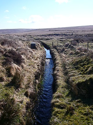
A leat is the name, common in the south and west of England and in Wales, for an artificial watercourse or aqueduct dug into the ground, especially one supplying water to a watermill or its mill pond. Other common uses for leats include delivery of water for hydraulic mining and mineral concentration, for irrigation, to serve a dye works or other industrial plant, and provision of drinking water to a farm or household or as a catchment cut-off to improve the yield of a reservoir.

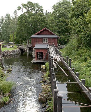
A watermill or water mill is a mill that uses hydropower. It is a structure that uses a water wheel or water turbine to drive a mechanical process such as milling (grinding), rolling, or hammering. Such processes are needed in the production of many material goods, including flour, lumber, paper, textiles, and many metal products. These watermills may comprise gristmills, sawmills, paper mills, textile mills, hammermills, trip hammering mills, rolling mills, wire drawing mills.

A water wheel is a machine for converting the energy of flowing or falling water into useful forms of power, often in a watermill. A water wheel consists of a wheel, with a number of blades or buckets arranged on the outside rim forming the driving car. Water wheels were still in commercial use well into the 20th century but they are no longer in common use. Uses included milling flour in gristmills, grinding wood into pulp for papermaking, hammering wrought iron, machining, ore crushing and pounding fibre for use in the manufacture of cloth.

A weir or low head dam is a barrier across the width of a river that alters the flow characteristics of water and usually results in a change in the height of the river level. Weirs are also used to control the flow of water for outlets of lakes, ponds, and reservoirs. There are many weir designs, but commonly water flows freely over the top of the weir crest before cascading down to a lower level. There is no single definition as to what constitutes a weir, and one English dictionary simply defines a weir as a small dam.
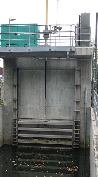
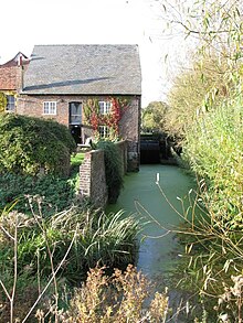
A sluice is a channel controlled at its head by a movable gate which is called a sluice gate. A sluice gate is traditionally a wood or metal barrier sliding in grooves that are set in the sides of the waterway and can be considered as a bottom opening in a wall. Sluice gates are one of the most common hydraulic structures in controlling flow rate and water level in open channels such as rivers and canals. They also could be used to measure the flow. A water channel containing a sluice gate forms a type of lock to manage the water flow and water level. It can also be an open channel which processes material, such as a River Sluice used in gold prospecting or fossicking. A mill race, leet, flume, penstock or lade is a sluice channeling water toward a water mill. The terms sluice, sluice gate, knife gate, and slide gate are used interchangeably in the water and wastewater control industry. They are also used in wastewater treatment plants and to recover minerals in mining operations, and in watermills.

The River Cole is a 25 miles (40 km) river in the English Midlands. It rises on the lower slopes of Forhill, one of the south-western ramparts of the Birmingham Plateau, at Red Hill and flows south before flowing largely north-east across the plateau to enter the River Blythe below Coleshill, near Ladywalk, shortly before the Blythe meets the Tame. This then joins the Trent, whose waters reach the North Sea via the Humber Estuary. Its source is very near the main watershed of Midland England : tributaries are few and very short except in the lower reaches, so the Cole is only a small stream.

The River Rother, a waterway in the northern midlands of England, gives its name to the town of Rotherham and to the Rother Valley parliamentary constituency. It rises in Pilsley in Derbyshire and flows in a generally northwards direction through the centre of Chesterfield, where it feeds the Chesterfield Canal, and on through the Rother Valley Country Park and several districts of Sheffield before joining the River Don at Rotherham in Yorkshire. Historically, it powered mills, mainly corn or flour mills, but most had ceased to operate by the early 20th century, and few of the mill buildings survive.

Claverton Pumping Station in the village of Claverton, in the English county of Somerset, pumps water from the River Avon to the Kennet and Avon Canal using power from the flow of the river. It is a Grade I listed building, having been upgraded from Grade II in 2019.
A flume is a human-made channel for water, in the form of an open declined gravity chute whose walls are raised above the surrounding terrain, in contrast to a trench or ditch. Flumes are not to be confused with aqueducts, which are built to transport water, rather than transporting materials using flowing water as a flume does. Flumes route water from a diversion dam or weir to a desired materiel collection location. Flumes are usually made up of wood, metal or concrete.

The Tumbling Weir is a circular weir in the town of Ottery St. Mary, Devon, England that allows water from a leat or man-made stream to reach the River Otter.

A penstock is a sluice or gate or intake structure that controls water flow, or an enclosed pipe that delivers water to hydro turbines and sewerage systems. The term is inherited from the earlier technology of mill ponds and watermills.

Dalgarven Mill is near Kilwinning, in the Garnock Valley, North Ayrshire, Scotland and it is home to the Museum of Ayrshire Country Life and Costume. The watermill has been completely restored over a number of years and is run by the independent Dalgarven Mill Trust.

Stainton Beck is a watercourse in Cumbria, England. Its upper reaches are known as St. Sunday's Beck.

A mill pond is a body of water used as a reservoir for a water-powered mill.

The River Teise is a tributary of the River Medway in Kent, England.

The River Gavenny or sometimes the Gavenny River is a short river in Monmouthshire in south Wales. It rises 1 mile (1.6 km) southwest of the village of Llanvihangel Crucorney from springs near Penyclawdd Court, supplemented by springs in Blaen-Gavenny Wood and tributary streams there and within the Woodland Trust-owned Great Triley Wood. It flows south for about 4 miles (6.4 km) to its confluence with the River Usk towards the eastern end of Castle Meadows at Abergavenny. The town derives its English-language name from the Gavenny's confluence with the River Usk. Of the buildings on the banks of the river, the Gothic Decorated style church of St Teilo at Llantilio Pertholey is especially notable. Parts of the church date from the thirteenth century with multiple additions since. Blaengavenny Farm, the name of which signifies the 'head of the Gavenny', is a sixteenth century farmhouse near the river's source.
Race, RACE or The Race may refer to:

The Land Yeo is a small river which flows through North Somerset, England. It rises on Dundry Hill and supplies Barrow Gurney Reservoirs before flowing through various villages to Clevedon where it drains into the Severn Estuary. During the past 1,000 years it has powered at least ten watermills, however only one is still functional. Since 2003 initiatives have been undertaken to clean up the river, improving water quality and encouraging wildlife.

Millbank Mill or Meikle Millbank Mill was an old corn mill in Burnbank Glen overlooking the Barr Loch near Lochwinnoch in Renfrewshire, south-west Scotland. The present ruins date from at least the end of the 18th century with structural evidence for six phases of development that finally ceased when the mill closed circa 1950. The mill was a two storey building, developed to become 'T' shaped complex when at a later stage a grain kiln was added.

Nether Mill or the Nethermiln of Kilbirnie was originally the Barony of Kilbirnie corn mill and later became a meal mill as well, located in the Parish of Kilbirnie, near Kilbirnie Loch, North Ayrshire, south-west Scotland. The present ruins date from at least the start of the 20th century with structural evidence for at least three phases of development that finally ceased when the mill closed and abandoned c. 1938. The mill was probably a single storey building, developed to become a complex when at a later stage buildings such as a grain kiln, cottage and a wheel house enclosure may have been added. The mound near the site is locally known as the 'Miller's Knowe'. Kilbirnie Ladeside F.C. is named for the lade of the mill that has its confluence with the Garnock opposite the club's grounds.