Ballynacargy

Last updated

Ballynacargy
Baile na Carraige
Village
Ballynacargy, County Westmeath - geograph.ie - 1827161.jpg
Ballynacargy's main street
Ireland adm location map.svg
Red pog.svg
Ballynacargy
Location in Ireland
Coordinates: 53°34′58″N7°32′14″W / 53.5827°N 7.5372°W / 53.5827; -7.5372
Country Ireland
Province Leinster
County County Westmeath
Government
   Dáil Éireann Longford–Westmeath
Area
  Total0.372 km2 (0.144 sq mi)
Population
 (2016) [1]
  Total277
  Density740/km2 (1,900/sq mi)
Time zone UTC+0 (WET)
  Summer (DST) UTC-1 (IST (WEST))

Ballynacargy, or Ballinacarrigy, (Irish : Baile na Carraige) [2] is a small village in County Westmeath, Ireland on the Royal Canal and the R393 regional road. The last official commercial navigation of the canal took place in 1955.

Contents

Public transport

Bus Éireann route 448 provides a link to Mullingar on Fridays only departing at 10.15 and returning from Mullingar at 13.30. The nearest railway station is Mullingar railway station approximately 15 kilometres distant. Until August 2013, Bus Éireann route 118 (Dublin-Mullingar-Longford) served Ballynacargy on Saturdays only allowing passengers to travel into Longford for a few hours. [3] [4]

History

Ballynacargy is thought to have been largely established in the mid-18th century by the Malone family of Baronstown, who intended to create a linen industry in the area. While the linen trade failed to thrive, the village gained a harbour on the Royal Canal which opened in 1817, and developed as a market serving the surrounding district. However, the origins of the village go back much further, and its immediate area includes some of the most important historical and archaeological sites in Westmeath. The first recorded reference dates from 1537 after the dissolution of the nearby monastery at Tristernagh Abbey.

Kilbixy

It is thought that the village of Ballynacargy initially grew as a result of the decline of nearby Kilbixy, an important town in Meath 500 years ago.

Kilbixy (from the Irish Cill Bigsighe) developed around an early Christian church reputedly founded by Saint Bigseach, a handmaiden of Saint Brigid whose feast day was celebrated on 28 June and 4 October. A castle was built here by Walter de Lacy in 1192, following which a Norman settlement grew up and was granted Borough rights. Kilbixy was said to have once had twelve burgesses and a mayor, [5] along with the castle, church, a market and a dock on the shore of Lough Iron, but declined and was deserted during the 15th century after being repeatedly attacked and burned, first in 1430 by Owen O'Neill, King of Tyrone, and then by the locally powerful Geoghegan family. [6] By the 17th century only a few ruins remained of the former town. Despite the town's disappearance, the parish still bears the name of Kilbixy.

The Church of Ireland parish church, dedicated to St Bigseach, is located within the former area of Kilbixy town itself, in Baronstown Demesne townland to the north of Ballynacargy village. It was built, probably on the same site as Kilbixy's original church, in 1798 to the designs of James Wyatt, one of the greatest architects of the time: the area around it remains one of the best-preserved examples of a deserted medieval borough in Ireland. [7] In 1980 a 7th-century stone was discovered in the circular churchyard, showing it to have been a very early foundation. [8] The 1798 church was funded by The 1st Baron Sunderlin, and is a good example of a church of the period sited to provide a picturesque landscape view from the local big house. [9] Lord Sunderlin also built a large mausoleum next to the church: Sunderlin's brother, the celebrated Shakespearean scholar Edmond Malone, is also buried there. In the 19th century, St Bigseach's churchyard still remained a favoured place of interment for local Catholic families, as well as Anglicans. [10] There is a holy well, Tobar Bigsighe ("the well of Bigseach") nearby.

Templecross

Northeast of the village in the townland of Tristernagh Demesne are the ruins of Templecross Church, from where the ruins of Tristernagh Abbey are visible. Templecross is probably late-medieval in date, with a west tower built in c. 1575. [11] Within the church is the tomb of the landowner Henry Piers (1568-1623), who after embracing Catholicism and travelling widely in Europe, restored the Abbey buildings and church: at the tomb's foot was a memorial to Gerald Farrell and his wife Elizabeth, who had been foster parents of Sir Henry Piers, 1st Baronet. [12] By the late 17th century the building had been converted to a Protestant church, as the main church at Kilbixy was then derelict. Templecross churchyard contains a number of historic monuments: there are several to 19th-century Catholic priests who served Ballinacargy, [11] including the Rev. John Cantwell, PP, who was well known locally for his work with the poor and his promotion of education. [13] The base of an early stone cross is also located in the churchyard. A lane known locally as Bóithrín na marbh ("little road of the dead") once ran from the north side of the churchyard to Ballynacroghy or Gallowstown townland. [14]

Tristernagh Abbey

The house of Augustinian canons, also known as the Priory of Kilbixy, was founded in 1192 by Geoffrey de Constantine. Attached to the monastery was a leper hospital, a rarity at that time. The priory achieved some fame from its establishment until 1536 when the commissioners of the English King Henry VIII ransacked and destroyed it.

Notable people

See also

Related Research Articles

<span class="mw-page-title-main">Ballymahon</span> Town in Leinster, Ireland

Ballymahon on the River Inny is a town in the southern part of County Longford, Ireland. It is located at the junction of the N55 National secondary road and the R392 regional road.

<span class="mw-page-title-main">Mullingar</span> Town in County Westmeath, Ireland

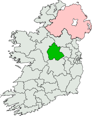
Mullingar is the county town of County Westmeath in Ireland. It is the third most populous town in the Midland Region, with a population of 22,667 in the 2022 census.

<span class="mw-page-title-main">Castlepollard</span> Village in County Westmeath, Ireland

Castlepollard is a village in north County Westmeath, Republic of Ireland. It lies west of Lough Lene and northeast of Lough Derravaragh and Mullingar.

<span class="mw-page-title-main">Kilbeggan</span> Town in County Westmeath, Ireland

Kilbeggan is a town in County Westmeath, Ireland. It is in the barony of Moycashel.

<span class="mw-page-title-main">Longford–Westmeath (Dáil constituency)</span> Dáil constituency (1921–1937, 1948–1992, 2007–present)

Longford–Westmeath is a parliamentary constituency represented in Dáil Éireann, the lower house of the Irish parliament or Oireachtas. The constituency elects 4 deputies on the system of proportional representation by means of the single transferable vote (PR-STV).

<span class="mw-page-title-main">Killucan and Rathwire</span> Town in Leinster, Ireland

The villages of Killucan and Rathwire are co-located in the east of County Westmeath, Ireland. They have a combined population of 1,370 according to the 2016 census. Killucan is on the R156 road about 15 km (9.3 mi) from Mullingar and 60 km (37 mi) from Dublin.

<span class="mw-page-title-main">Collinstown</span> Village in Leinster, Ireland

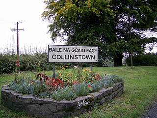
Collinstown is a village in north County Westmeath, situated on the R395 regional road overlooking Lough Lene. It lies 18 km (11 mi) northeast of the county town of Mullingar and had a population of 356.

<span class="mw-page-title-main">Castletown Geoghegan</span> Village in County Westmeath, Ireland

Castletown Geoghegan is a village in County Westmeath, Ireland, and lies south west of Lough Ennell near the county town of Mullingar. It is around 13 km south-west of Mullingar and 19 km north of Tullamore. Castletown was the seat of the Geoghegan family of the medieval Barony of Moycashel in County Westmeath.

<span class="mw-page-title-main">Ballymore, County Westmeath</span> Village in Leinster, Ireland

Ballymore is a village in County Westmeath, Ireland, on the R390 road between Athlone and Mullingar. The historic Hill of Uisneach is nearby. The village was known in medieval times as the medieval borough of Ballymore Lough Sewdy, or Loughsewdy, after the nearby lake, the site of an ancient bruighean, or hostel.

<span class="mw-page-title-main">Newtown Forbes</span> Village in Leinster, Ireland

Newtown Forbes is a large village in County Longford, Ireland. It was historically called Lisbrack, an anglicisation of the Irish name.

<span class="mw-page-title-main">Tristernagh Abbey</span> Ruined Augustinian friary in Westmeath, Ireland

Tristernagh Abbey, also known as the Priory of Kilbixy or Kilbisky, Tristernagh Priory, or the priory of the Blessed Virgin Mary of Tristernagh, is a ruined Augustinian monastery in the townland of Tristernagh in the barony of Kilbixy in County Westmeath, Ireland. It is situated on the shores of Lough Iron, about 3 kilometres (1.9 mi) north east of the village of Ballynacargy.

<span class="mw-page-title-main">Moygoish</span> Barony in Leinster, Ireland

Moygoish is a barony in north County Westmeath, in Ireland, formed by 1672. It is bordered by County Longford to the west and four other Westmeath baronies: Corkaree, Fore, Moyashel and Magheradernon and Rathconrath to the south–west.

<span class="mw-page-title-main">Moyashel and Magheradernon</span> Barony in County Westmeath, Ireland

Moyashel and Magheradernon is a barony in the centre of County Westmeath, in Ireland, formed by 1672. It is bordered by eight other baronies: Corkaree and Fore, Delvin and Farbill, Fartullagh and Moycashel and Rathconrath and Moygoish.

<span class="mw-page-title-main">Farbill</span> Barony in Leinster, Ireland

Farbill is a barony in east County Westmeath, in Ireland. It was formed by 1672. It is bordered by County Meath to the south and east and three other baronies: Fartullagh, Moyashel and Magheradernon and Delvin. The largest centre of population in the barony is the town of Kinnegad.

Leny is a civil parish in County Westmeath, Ireland. It is located about 10.5 kilometres (7 mi) north–west of Mullingar. This name also applies to the townland of Leny; neither should be confused with the Falls of Leny in Scotland.

Templeoran is a civil parish in County Westmeath, Ireland. It is located about 8.4 kilometres (5 mi) north‑west of Mullingar.

Kilbixy is a civil parish in County Westmeath, Ireland. It is located about 13.25 kilometres (8 mi) north‑west of Mullingar. The village of Ballynacarrigy is the largest settlement in the parish.

Grange is a townland in County Westmeath, Ireland. It is located about 11.3 kilometres (7 mi) north–west of Mullingar.

Rathaspick is a civil parish in County Westmeath, Ireland. It is located about 18.17 kilometres (11 mi) north–west of Mullingar.

Piercetown is a civil parish in County Westmeath, Ireland. It is located about 18.69 kilometres (12 mi) west–north–west of Mullingar. It was formerly often spelled Pierstown.

References

  1. "Sapmap Area - Settlements - Ballynacargy". Census 2016. Central Statistics Office. April 2016. Retrieved 16 March 2020.
  2. "Baile na Carraige/Ballynacarrigy". Placenames Database of Ireland (logainm.ie). Retrieved 17 October 2021.
  3. "Bus Éireann News - Bus Éireann - View Ireland Bus and Coach Timetables & Buy Tickets".
  4. "Dublin Airport - Bus Éireann - View Ireland Bus and Coach Timetables & Buy Tickets".
  5. Casey and Rowan The Buildings of Ireland: North Leinster, p.346
  6. Woods, Annals of Westmeath, 1907, p.290
  7. St Bigseach's Church of Ireland, Buildings of Ireland
  8. Ambitious Plans to Restore 5th-century Kilbixy Church, 'Westmeath Examiner, 22-09-10
  9. Howley, The Follies and Garden Buildings of Ireland, 2004, p.171
  10. O'Hanlon, Lives of the Irish Saints, vol X, p.44
  11. 1 2 Templecross Church, County Westmeath, Buildings of Ireland
  12. Association for Preservation of Memorials of the Dead, Ireland, Journal for 1901, Vol 5, 1, 119
  13. Woods, 1907, p.311
  14. Ballynacargy, National Folklore Collection, UCD
  15. Sheehan, Worthies of Westmeath: A Biographical Dictionary with Brief Lives of Famous Westmeath People, 1987, p.36