A ring road (also known as circular road,beltline, beltway, circumferential (high)way, loop or orbital) is a road or a series of connected roads encircling a town, city or country. The most common purpose of a ring road is to assist in reducing traffic volumes in the urban centre, such as by offering an alternate route around the city for drivers who do not need to stop in the city core. Ring roads can also serve to connect suburbs to each other, allowing efficient travel between them.
In Europe and Australia, some ring roads, particularly longer ones of motorway standard, are known as "orbital motorways". Examples are the London Orbital (generally known as the M25; 188km), Sydney Orbital Network (110km), and Rome Orbital (68km).
In the United States many ring roads are called beltlines, beltways or loops, such as the Capital Beltway around Washington, D.C. Some ring roads, such as Washington's Capital Beltway, use "Inner Loop" and "Outer Loop" terminology for directions of travel, since cardinal (compass) directions cannot be signed uniformly around the entire loop. The term 'ring road' is occasionally – and inaccurately – used interchangeably with the term 'bypass'.
Background
The Sydney Orbital Network, New South Wales, AustraliaThe Autostrada A58, the Milan external east ring road, Italy. Together with the Autostrada A50 (Milan west ring road), the Autostrada A51 (Milan east ring road) and the Autostrada A52 (Milan north ring road), it is the largest system of ring roads around a city in Italy, for a total length greater than 100 kilometres (62mi).
Bypasses around many large and small towns were built in many areas when many old roads were converted to four-lane status in the 1930s to 1950s, such as those along the Old National Road (now generally U.S. 40 or Interstate 70) in the United States, leaving the old road in place to serve the town or city, but allowing through travelers to continue on a wider, faster and safer route.
Construction of fully circumferential ring roads has generally occurred more recently, beginning in the 1960s in many areas, when the U.S. Interstate Highway System and similar-quality roads elsewhere were designed. Ring roads have now been built around numerous cities and metropolitan areas, including cities with multiple ring roads, irregularly shaped ring roads and ring roads made up of various other long-distance roads.
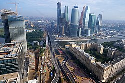
London has three ring roads (the M25 motorway, the North and South Circular roads and the Inner Ring Road). Birmingham also has three ring roads which consist of the Birmingham Box; the A4540, commonly known as the Middleway; and the A4040, the Outer Ring Road. Birmingham once had a fourth ring road, the A4400. This has been partially demolished and downgraded to improve traffic flow into the city. Other British cities have two: Leeds, Sheffield, Norwich and Glasgow. Cleveland, OH and San Antonio, TX, in the United States, also each have two, while Houston, Texas will have three official ring roads (not including the downtown freeway loop). Some cities have far more–Beijing, for example, has six ring roads, simply numbered in increasing order from the city center (though skipping #1), while Moscow has five, three innermost (Central Squares of Moscow, Boulevard Ring and Garden Ring) corresponding to the concentric lines of fortifications around the ancient city, and the two outermost (MKAD and Third Ring) built in the twentieth century, though, confusingly, the Third Ring was built last.
Geographical constraints can complicate the construction of a complete ring road. For example, the Baltimore Beltway in Maryland formerly crossed Baltimore Harbor on a high arch bridge prior to its collapse in 2024, and much of the partially completed Stockholm Ring Road in Sweden runs through tunnels or over long bridges. Some towns or cities on sea coasts or near rugged mountains cannot have a full ring road. Examples of such partial ring roads are Dublin's ring road; and, in the US, Interstate 287, mostly in New Jersey (bypassing New York City), and Interstate 495 around Boston, none of which completely circles these seaport cities.
In other cases, adjacent international boundaries may prevent ring road completion. Construction of a true ring road around Detroit is effectively blocked by its location on the border with Canada and the Detroit River; although constructing a route mostly or entirely outside city limits is technically feasible, a true ring around Detroit would necessarily pass through Canada, and so Interstate 275 and Interstate 696 together bypass but do not encircle the city. Sometimes, the presence of significant natural or historical areas limits route options, as for the long-proposed Outer Beltway around Washington, D.C., where options for a new western Potomac River crossing are limited by a nearly continuous corridor of heavily visited scenic, natural, and historical landscapes in the Potomac River Gorge and adjacent areas.
When referring to a road encircling a capital city, the term "beltway" can also have a political connotation, as in the American term "Inside the Beltway", derived metonymically from the Capital Beltway encircling Washington, D.C.
Impact
Ring roads decentralize traffic by providing alternative routes around the city, allowing through-traffic and freight flows to bypass the urban core. This relieves pressure on heavily congested inner-city roads and reduces the volume of unwanted transit movements that would otherwise enter central districts. At the same time, orbitals reshape metropolitan structure: accessibility often becomes highest along the ring, drawing economic activity and population towards suburban areas. This decentralization can increase car dependence and generate new inter-suburban traffic, which over time may erode some of the initial congestion benefits.[2]
A comparative analysis of ring-road schemes in multiple cities concluded that orbital roads tend to relieve congestion only temporarily, as traffic volumes rise again through induced demand. The study found that long-term congestion reduction requires combining ring roads with comprehensive travel-demand management measures, such as improved public transport, congestion charging, and compact land-use planning, rather than relying on road construction alone.[2]
Ring roads have been criticised for inducing demand, leading to more car journeys being taken and thus higher levels of pollution being created. By creating easy access by car to large areas of land, they can also act as a catalyst for development, leading to urban sprawl and car-centric planning.[3] Ring roads have also been criticised for splitting communities and being difficult to navigate for pedestrians and cyclists.[4]
The Leeds Inner Ring Road in England was built in a series of tunnels to save space and avoid physically separating the city's centre from its suburbs.Sardar Patel Ring Road, Ahmedabad
Most orbital motorways (or beltways) are purpose-built major highways around a town or city, typically without either signals or road or railroad crossings. In the United States, beltways are commonly parts of the Interstate Highway System. Similar roads in the United Kingdom are often called "orbital motorways". Although the terms "ring road" and "orbital motorway" are sometimes used interchangeably, "ring road" often indicates a circumferential route formed from one or more existing roads within a city or town, with the standard of road being anything from an ordinary city street up to motorway level. An excellent example of this is London's North Circular/South Circular ring roads, which are largely made up of (mainly congested) ordinary city streets.
In some cases, a circumferential route is formed by the combination of a major through highway and a similar-quality loop route that extends out from the parent road, later reconnecting with the same highway. Such loops not only function as a bypass for through traffic, but also to serve outlying suburbs. In the United States, an Interstate highway loop is usually designated by a three-digit number beginning with an even digit before the two-digit number of its parent interstate. Interstate spurs, on the other hand, generally have three-digit numbers beginning with an odd digit.
Within the United States, even numbered three digit interstate highways act a circumferential route of the two digit parent interstate. Some instances (such as Interstate 495, DC) completely circle, while some (such as Interstate 495, MA) partially loop, either due to geographical or cancelled/non-completed highways. Within cities, ring roads sometimes have local nicknames; these include Washington DC's Interstate 495 (The "Capital Beltway"), Interstate 270 in Columbus, Ohio (The "Outerbelt"), and Interstate 285 in Atlanta (The "Perimeter").
The longest complete belt road, or a beltway that is only two lanes, in the United States is Hawaii Belt Road, a 260-mile (420km) belt in Hawaii that forms a complete belt road around Hawaii Island. [6]
Other major U.S. cities with such a beltway superhighway:
Boston—Route 128/Interstate 95 and Interstate 93/U.S. Route 1 form an inner beltway, and Interstate 495 (Massachusetts) forms an outer beltway. Inside the inner Route 128/I-95 and I-95/US 1 beltway, there were proposals (sinced canceled) for another beltway (at the time called the "Inner Belt" that would have carried Interstate 695; I-95 would have entered Boston via the Southwest Corridor (Since redeveloped as part of the Northeast Corridor Mile Posts 217.3-228.7), while the rest of the belt would have carried Interstate 695.
Providence, Rhode Island—Rhode Island Route 10 serves as a partial inner beltway, while Interstate 295 serves as a partial beltway to the west of Providence. Two different proposals (both since canceled) would have completed the outer I-295 beltway; the unbuilt sections were going to be designated Interstate 895.
Edmonton, Alberta, has two ring roads. The first is a loose conglomeration of four major arterial roads with an average distance of 6 kilometres (3.7mi) from the downtown core. Yellowhead Trail forms the northern section, Wayne Gretzky Drive/75Street forms the eastern section, Whitemud Drive forms the southern and longest section, and 170Street forms the western and shortest section. Whitemud Drive is the only section that is a true controlled-access highway, while Yellowhead Trail and Wayne Gretzky Drive have interchanges and intersections and are therefore both limited-access roads. Yellowhead Trail is currently being upgraded to full freeway standards. 170Street and 75Street are merely large arterial roads with intersections only.[7] The second and more prominent ring road is named Anthony Henday Drive; it circles the city at an average distance of 12 kilometres (7.5mi) from the downtown core. It is a freeway for its entire 78-kilometre (48mi) length, and was built to reduce inner-city traffic congestion, created a bypass of Yellowhead Trail, and has improved the movement of goods and services across Edmonton and the surrounding areas. It was completed in October 2016 as the first free-flowing orbital road in Canada.[8][9]
Stoney Trail is a ring road that circles the city of Calgary, Alberta, for an entire length of 101-kilometre (63mi).[10]
Regina, Saskatchewan has a partial ring road that is named Ring Road; however, due to the city's urban growth since the road was originally constructed, it no longer functions as a true ring road and has instead come to be used partially for local arterial traffic. The Regina Bypass, a new partial ring road, has replaced it, although Ring Road must still be used in the northeast quadrant of the city.
Sudbury, Ontario, has a partial ring road consisting of the Southwest and Southeast Bypasses segment of Highway 17, and the Northwest Bypass segment of Highway 144. An unofficial northeast "bypass" route can also be completed on city arterial roads that largely bypass the urban core of the city, but are not fully controlled-access and must be shared with local traffic in the Nickel Centre and Rayside-Balfour districts of the city.
Most major cities in Europe are served by a ring road that circles either the inner core of their metropolitan areas or the outer borders of the city proper or both. In major transit hubs, such as the Île-de-France region surrounding Paris and the Frankfurt area, major national highways converge just outside city limits before forming one of several routes of an urban network of roads circling the city. Unlike in United States, route numbering is not a challenge on European ring roads as routes merge to form the single designated road. However, exit and road junction access can be challenging due to the complexity of other routes branching from or into the ring road.
One of the most renowned ring roads is the Vienna Ring Road (Ringstraße), a grand boulevard constructed in the mid-19th century and filled with representative buildings. Due to its unique architectural beauty and history, it has also been called the "Lord of the ring roads", and is declared by UNESCO as part of Vienna's World Heritage Site.[11][12]
Major European cities that are served by a ring road or ring road system:
Milan, Italy – Autostrada A4, Autostrada A50 (West), Autostrada A51 (East), Autostrada A52 (North) and Autostrada A58 (Outer Eastern) bypass roads (it is the largest system of ring roads around a city in Italy, for a total length greater than 100 kilometres (62mi)[1]), Circolare Esterna (periphery ring road), Circonvallazione (ring road around the centre), Cerchia Interna (ring road in the city centre)
In Iceland, there is a 1,332km ring road, called the ring road (or Route 1), around most of the island (excluding only the remote Westfjords). Most of the country's settlements are on or near this road.
Chiang Mai, Thailand – Chiang Mai Outer Ring Road (National Highway 121)
Christchurch, New Zealand – Christchurch Ring Road includes parts of State Highways 1, 74, and 76. The "Four Avenues" (Bealey Avenue, Fitzgerald Avenue, Moorhouse Avenue, and Deans Avenue) serve as an inner ring around the central city.
↑"Northeast Anthony Henday Drive". Alberta Transportation. 2016. Archived from the original on 12 October 2016. Retrieved 2 October 2016. The northeast leg of Anthony Henday Drive opened on October 1, 2016, after five years of construction...
↑"Historic Centre of Vienna". whc.unesco.org. UNESCO World Heritage Centre. Archived from the original on 2 November 2011. Retrieved 15 September 2016.
This page is based on this Wikipedia article Text is available under the CC BY-SA 4.0 license; additional terms may apply. Images, videos and audio are available under their respective licenses.