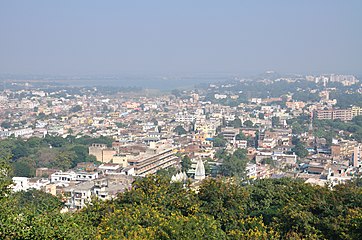
Ranchi is also one of the oldest cities in Jharkhand. Jagannath Temple and Ratu Palace are some sights which witnessed the history of Ranchi.[9]
Ranchi is rapidly growing its economy, and certain parks, special economic zones and industrial areas are being developed. Of late, new sectors and modern areas have been built for the city's development.[10] Ranchi is also nicknamed the City of Waterfalls.[11]
Etymology
According to one popular tale, Captain choose "Archi" an Oraon tribal village as headquarters. Archi means Bamboo forest in local Nagpuri dialect. The British inadvertently named "Archi" as "Ranchi". Captain Thomas Wilkinson renamed Kishunpur village as Rachi. Up to 1927, the place was known as Rachi.[12][13][14]
In his book The Mundas and Their Country, anthropologist Sarat Chandra Roy writes that the name of the city is derived from the Mundari word aranchi or "short stick" used in driving cattle.[15] while other opined that aranchi is bi-weekly market.[16]
According to another local story, the name of Ranchi comes from a local bird named "Rici" which was mostly found in the Pahari Mandir premise.[citation needed]Rici is name for Black Kite (Milvus migrans) in Mundari language, the modern-day landmark of Ranchi city, the Pahari Mandir, is also known as Rici Buru (रिचि बुरु) - the hill of the kites,[17] and the city originated on the foothills of Rici Buru with the construction of Bada Talab by Commissioner Thomas Wilkinson at the same site.
The earliest evidence of use of several iron slag, pot sheds, iron tools found in Chota Nagpur region around 1400 BCE.[18]Magadha Empire exercised indirect control over the territory, which lasted until the reign of the Ashoka. Armies of Samudra Gupta passed through the region on their expedition to the Deccan. In the 4th century CE, Nagvanshi king Raja Pratap Rai chose Chutia as his capital which is now a place in Ranchi. Few ruins of Chutia trace back to the 2nd century CE.[12][19][20][21] With the expansion of the Mughal Empire, the sovereign status of the Nagvanshi dynasty was technically affected, but they continued to rule and administer independently. Thakur Ani Nath Shahdeo made Satranji as capital of Barkagarh estate near Subarnarekha river. He built Jagannath Temple in 1691.[22][23]
After the Battle of Buxar, Nagvanshi became a vassal of the East India Company. The British reduced Nagvanshi rulers to Jamindar in 1817 due to rebellion of Jagirdars under Nagvanshi against tax imposition by East India Company and directly ruled Chotanagpur.[24] In 1833, Captain Wilkinson established headquarter of the South-West Frontier agency in the village of Kishunpur, which he renamed into Ranchi after the hamlet located at the foot of the Hill.[25][26] In 1855, Thakur Vishwanath Shahdeo declared independene from British rule. British attacked Satranji but he defeated British forces. He ruled independently for two years.[27] In the Indian Rebellion of 1857, Thakur Vishwanath Shahdeo led soldiers of Ramgarh Battalion with Madhav Singh who was Jamadar of Ramgarh Battalion. Pandey Ganpat Rai, Tikait Umrao Singh and Sheikh Bhikhari also joined the rebellion. They attacked the British in Ranchi and compelled to flee them. But later they were defeated by East India company forces in Chatra and in Pithuriya with the help of the king of Pithuriya, Jagatpal Singh and hanged.[27][28][29] British made Ranchi as municipality in 1869 and Ranchi was first termed as a town in the census of 1872.[30] Nagvanshi shifted their capital to Ratu from Palkot in 1870. Udai Pratap Nath Shah Deo built Ratu Palace in Ratu in 1900. He donated large tracts of land to build the infrastructure of the city.[31] Freedom fighter Birsa Munda died in the Ranchi jail on 9 June 1900.[32] In 1912, Jyotirindranath Tagore, the eldest brother of Rabindranath Tagore, settled in Ranchi. Tagore Hill, where his house was located, has been named after him in remembrance.[33] The last ruler of the Nagvanshi dynasty was Lal Chintamani Sharan Nath Shahdeo (1931–2014).[34]
After independence, Ranchi saw significant increase in its population. Its population rate of growth was 3.5% in 1901 to 1941, which increased to 14% in 1951–1971.[30] This was because of increased industrial and educational institutions being set up, as well as the arrival of post-partition refugees. Ranchi became an 'administrative-cum-industrial' town in 1958 when Heavy Engineering Corporation was set up.[30] The succeeding years saw Ranchi becoming the headquarters for the Steel Authority of India Ltd and Central Coalfields Ltd.[25] The city remained the summer capital of Bihar till the creation of Jharkhand in 2000, when Ranchi became the capital of the new state.[35]
Ranchi has a hilly topography and its dense tropical forests a combination that produces a relatively moderate climate compared to the rest of the state. However, due to the uncontrolled deforestation and development of the city, the average temperature has increased.[36]
Although Ranchi has a humid subtropical climate (Köppen Climate Classification: Cwa), its location and the forests surrounding it combine to produce the unusually pleasant climate for which it is known. Summer temperatures range from 20 to 42°C, winter temperatures from 0 to 25°C. December and January are the coolest months, with temperatures dipping to the freezing point in some areas (Kanke). The annual rainfall is about 1430mm (56.34inches). From June to September the rainfall is about 1,100mm.[37]
Climate data for Ranchi (1981–2010, extremes 1951–2009)
As of 2011[update] India census,[41]Ranchi Municipal Corporation has a population of 1,073,427, The urban agglomeration had a population of 14,56,528 making it the 32nd most populous urban agglomeration in India. Males constitute 52.1% of the population and females 47.9%.[42] Ranchi has an average literacy rate of 87.68%.
The city witnessed a sudden surge in population after the declaration of the new state of Jharkhand in 2000. Owing to the rising employment opportunities and opening of numerous regional and state level offices, banks and FMCG companies, the city witnessed a rapid influx of employment seeking migrants. As per a study done by ASSOCHAM in late 2010, Ranchi was one of the highest employment generating Tier-III cities in India with a share of 16.8%, followed by Mangalore and Mysore.[43]
Hinduism is the prominent religion of Ranchi followed by 64.31% of the population. Islam is the second most followed religion in the city by 16.42% of the people. Minorities are Christians 8.52%, Sikhism 0.39%, Jains 0.22%, Buddhists 0.06%, those that did not state a religion are 0.35%, and others are 9.72%.[citation needed]
Governance and politics
Civic administration
The municipal corporation covers an area of 175km2 (68sqmi) and is divided into 55 administrative wards, each represented by an elected corporator.[1]
At the time of the creation of the state of Jharkhand in 2000, the Bihar Municipal Act, 1922 was adapted as the Jharkhand Municipal Act, 2000 to govern all ULBs in the new state. Ranchi Municipal Corporation was governed by its own municipal act, the Ranchi Municipal Corporation Act, 2001. With the enactment of the Jharkhand Municipal Act 2011, these two ceased to be in effect and the 2011 became the only governing legislature for all city governments in Jharkhand.[46]
Under section 26 of the Jharkhand Municipal Act, 2011, the positions of mayor and deputy mayor are elected directly i.e. the position holders are voted in by the people themselves.[47] The last municipal election was in 2018 with a voter turnout of 49.3%, up from 38% in the last election in 2013.[48][49] Asha Lakra and Sanjiv Vijayawargia – both from the Bharatiya Janta Party – won the mayoral and deputy mayoral seats.[50] The 2018 municipal election was the first time the mayoral and deputy mayoral candidates in Jharkhand could use political party symbols, while the candidates for councilor seats continued to use symbols allotted to them by the Jharkhand State Election Commission.[50][51] The next municipal election will take place in 2023.[52]
The Jharkhand Municipal Act, 2011 mandates the establishment of ward committees for each ward in the municipality.[47] Though ward committees have been formed in Ranchi, they are not active.[53]
The various infrastructure and civic services demands of the city are met by different entities, including Ranchi Municipal Corporation, state government departments, and parastatal organisations. The Ranchi Master Plan 2037 was created by a private consultant firm under the clientship of the Ranchi Municipal Corporation, Urban Development and Housing Department, and Ranchi Regional Development Authority.[56][57] Roads in Ranchi are developed and maintained by the municipal corporation, Jharkhand Government, Ranchi Regional Development Authority, and National Highways Authority of India.[58] The Water Supply Section of the municipal corporation is responsible for issuing water connections, maintaining hand pumps in wards, collecting water usage charges and fines, whereas the state government Drinking Water Supply and Sewerage Department supplies the water.[59][60] The Health Department of the corporation is responsible for the Solid Waste Management of the city. RMC operates buses in the city and has outsourced this to a private agency.[61]
Economy
Ranchi is one of the major industrial cities of Eastern India and located in the region called 'Ruhr of India' (Chota Nagpur) making it an ideal place for mineral based industries. Ranchi has presence of many well-known government and private organisations in the vicinity of city. SAIL-R&D, MECON.Ltd, Garden Reach Shipbuilders & Engineers (Marine Diesel Engine Project), Central Coalfields, CMPDI.Ltd, Subarnarekha Hydel Project (JSEB), Usha Martin.Ltd (Wire Rope Division),[62]DVC, STPI-Ranchi,[63]Heavy Engineering Corp., Palriwal Industries, Pensol India, Waxpol Industries, Jharkhand Mega Food Park etc. are the prominent industries here.
The Federation of Jharkhand Chamber of Commerce & Industries (FJCCI),[64]ASSOCHAM, MSME-DI and JIADA[65] are major apex industrial bodies present here. JIADA consists many industrial areas in Ranchi, e.g. – Kokar, Tatisilwai, Namkum etc. are among them.
As per a study done by ASSOCHAM in late 2010, Ranchi was the highest employment generating Tier-III cities in India followed by Mangalore and Mysore.[66]MECON Ltd Company has its headquarters in Ranchi at Ashok Nagar. Jharkhand Industrial Area Development Association has its office in Namkum. Central Coalfields also has its headquarters in Ranchi.
The main and major businesses here are located in Lalpur, Hindpiri, Lower Bazaar, Upper Bazaar and Doranda
STPI Ranchi has set up its branch at Namkum, Ranchi. It is usually an IT Park, which houses many IT companies. It is being planned to build more parks like this. OFFCO Park is another park which is built here. It is also a large and famous business park.
Lalpur, Doranda and Hindpiri are the business districts and financial districts in the city and the state. This place houses several shopping malls. Whole of Ranchi has several shopping malls which include: Nucleus Mall, Mall E Decor, JD Hi-Street Mall, Ranchi Central Mall, Laxmi Tower, Mall of Ranchi, City Center (Centre) Mall, Big Mall, Spring City Mall, Arakshan Shopping Mall, Shelter Mall, Ranchi Green City, Artic Mall, City Center or City Centre, City Mall and Galaxia Mall.
There are many other upcoming shopping malls and commercial projects
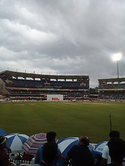
Ranchi is a center for numerous sports activities, including cricket, hockey, football, and many others.[71] The 34th National Games were successfully held in Ranchi in February 2011. An International Cricket stadium with an indoor stadium and a practice ground has been constructed. So far, this stadium has hosted three One day International matches and one T20 International match. Apart from that, this stadium has hosted two IPL 6 matches for Kolkata Knight Riders, three champions league 2013 matches and Celebrity Cricket League matches for Bhojpuri Dabanggs. A tennis academy, which was inaugurated by Sania Mirza and Shoaib Malik, also runs beside the cricket stadium. Former Indian Cricket Team Captain M.S. Dhoni lives in Ranchi.[72] The Ranchi franchise for Hockey India League was bought by Patel-Uniexcel Group and the team named the Ranchi Rhinos.[73]
Jharkhand is a state in eastern India. The state shares its border with the states of West Bengal to the east, Chhattisgarh to the west, Uttar Pradesh to the northwest, Bihar to the north and Odisha to the south. It is the 15th largest state by area, and the 14th largest by population. Hindi is the official language of the state. The city of Ranchi is its capital and Dumka its sub-capital. The state is known for its waterfalls, hills and holy places; Baidyanath Dham, Parasnath, Dewri and Rajrappa are major religious sites. Jharkhand is primarily rural, with about 24% of its population living in cities.
Jharkhand Mukti Morcha is a political party in the Indian state of Jharkhand which was founded by Binod Bihari Mahato. It has one seat in the 17th Lok Sabha. Shibu Soren is the president of the JMM. JMM is also an influential political party in the state of Odisha and parts of neighbouring of states. Its election symbol for Jharkhand is Bow and Arrow.
Ranchi district is the most populous district of Jharkhand state in eastern India. Ranchi, the capital of Jharkhand, is the district headquarters. It was established as a district in 1899.
The region have been inhabited since the Stone Age. Copper tools from the Chalcolithic period have been discovered. This area entered the Iron Age during the mid-2nd millennium BCE.
Ranchi district is one among the twenty-four districts of the state of Jharkhand in Eastern India. This region was under the control of the Magadha Empire, then it was a part of the Mauryan Empire under Ashoka and later a part of the Gupta Empire. After the fall of the Gupta Empire a legendary king named Phanimukut established the Nagvanshi dynasty and controlled the Chota Nagpur plateau region for several centuries thereafter.
Ram Dayal Munda, known as R. D. Munda, was an Indian scholar and regional music exponent. He was awarded the Padma Shri of the year 2010 for his contribution to the field of art.
Jaipal Singh Stadium is a multi-purpose stadium located in the city of Ranchi in Jharkhand, India. It was built in 1978 and was named after the famous hockey player and captain Jaipal Singh Munda after a request was made by Birsa Seva Dal.
The Nagvanshis of Chotanagpur, also known as the Khokhra chieftaincy, was an Indian dynasty which ruled the parts of Chota Nagpur plateau region during much of ancient, medieval and modern period. Phani Mukut Rai is considered the first king of dynasty claim to be son of Pundrika Naga, a mythical Naga. Lal Chintamani Sharan Nath Shahdeo (1931–2014) was last ruling king of the dynasty, until the estate was merged to the Republic of India.
In the Indian state of Jharkhand, films are produced in various regional and tribal languages including Kudmali, Hindi, Nagpuri, Khortha and Santali. Film industry in state of Jharkhand is also known as Jollywood.
The Nagpuria people, also Nagpuri or Sadan, are an Indo-Aryan speaking ethnolinguistic group who are the native speakers of the Nagpuri language and natives of the western Chota Nagpur Plateau region of Indian states of Jharkhand, Bihar, Chhattisgarh and Odisha.
Sadan are the native Indo-Aryan-speaking ethnolinguistic groups of Chota Nagpur Plateau consist of Indian state of Jharkhand and neighbouring states who speak Nagpuri, Khortha and Kurmali language as their native language.
Gopal Sharan Nath Shahdeo was a prince of the Nagvanshi royal family. He was twice the state legislative assembly member from Hatia in 2005 and 2009 as Indian National Congress candidate.
Lal Ranvijay Nath Shahdeo, was a lawyer, poet, writer and political activist. He was a prominent leader of the movement for a separate Jharkhand state. He was president of the Jharkhand Party. He wrote several Nagpuri poems, songs and slogans for the Jharkhand movement. At the end, the Central government of India accepted to form a new state, Jharkhand. He changed the state name Vananchal to Jharkhand after a debate with Prime minister Atal Bihari Vajpayee. He was the recipient of the Jharkhand Ratna Award for his contribution to the movement for a separate state of Jharkhand.
Lal Pingla Nath Shahdeo, was an Indian jurist and political activist. He had led movement for separate Jharkhand state in 1998-99 by forming committee of all political parties. He helped in achieving the status of a separate state for Jharkhand.
Udai Pratap Nath Shahdeo, was the Nagvanshi Maharaja of Chotanagpur Zamindari estate. He donated large tracts of land to build infrastructure of Ranchi city. He built the Ratu Palace in Ranchi in 1901. He was conferred the Kaiser-i-Hind Medal for public services. He reigned for 81 years, and 74 days, the longest-reigning Indian monarch, the longest-reigning Princely State ruler and third longest verifiable reign of any monarch in history.
The Barkagarh estate was a zamindari estate situated in modern-day Jharkhand, India, in erstwhile Lohardaga district. It was established by Ani Nath Shahdeo, the son of Nagvanshi king Ram Shah in 17th century. The capital of the estate was Satranji now located in south Ranchi.
Namkum is a neighbourhood of Ranchi in the Ranchi Sadar subdivision of the Ranchi district in the Indian state of Jharkhand.
Ranchi Sadar subdivision is an administrative subdivision in the Ranchi district of the South Chotanagpur division in the state of Jharkhand, India.
Jagannath Shah Deo was a Nagvanshi king in the 19th century. He succeeded Govind Nath Shah and ruled from 1822 to 1869 CE. During his reign, Kol uprising and Sepoy mutiny of 1857 happened. He was ally of British East India company. During his reign, Beniram Mehta had written the book Nagvanshavali, the genology of Nagvanshi kings in Nagpuri language which was published in 1876.
↑ Cultural Configuration of Ranchi, Lalita Prasad Vidyarthi, Rajendra Behari Lal, India. Planning Commission. Research Programmes Committee, 1969, pg 306.
↑ Journal and Proceedings of the Asiatic Society Of Bengal, Volume 4, No. 11, 1927, "The Etymology of Ranchi", pg 601.
↑ Mathur Das Ustad (1997). "The Role of Bishwanath Sahi of Lohardaga district, During the Revolt of 1857 in Bihar". Proceedings of the Indian History Congress. 58: 493–500. JSTOR44143953.
This page is based on this Wikipedia article Text is available under the CC BY-SA 4.0 license; additional terms may apply. Images, videos and audio are available under their respective licenses.