Jonha Falls

Last updated

Jonha Falls
Jonha falls.jpg
India Jharkhand relief map.svg
Red pog.svg
Jonha Falls
Location Ranchi district, Jharkhand
Coordinates 23°20′30″N85°36′30″E / 23.34167°N 85.60833°E / 23.34167; 85.60833
Total height43 metres (141 ft)
WatercourseRaru River

The Jonha Falls (also called Gautamdhara Falls) is a waterfall located in Ranchi district in the Indian state of Jharkhand.

Contents

Geography

Jonha Falls
Transparent.svg
Transparent.svg
17km
10.6miles
W
E
S
T
B
E
N
G
A
L
H
Khukhragarh
Transparent square.svg
R
Sikidiri
Transparent square.svg
R
Pithuriya
Transparent square.svg
R
Narkopi
Transparent square.svg
0
CCL North
Karanpura Area
Transparent square.svg
m
Koel
River
l
Damodar
River
k
Bhairavi
River
j
Karkari
River
i
Kanchi
River
h
Raru
River
g
Subarnarekha
River
D
Getalsud
Dam
Transparent square.svg
T
Dassam Falls
Transparent square.svg
T
Jonha Falls
T
Hundru
Falls
Transparent square.svg
CT
Tundul
Transparent square.svg
CT
Tati
Transparent square.svg
CT
Ray
Transparent square.svg
CT
Ratu
Transparent square.svg
N
Namkum
Transparent square.svg
CT
Muri
Transparent square.svg
CT
Khelari
Transparent square.svg
CT
Kanke
Transparent square.svg
CT
Irba
Transparent square.svg
CT
Churi
Transparent square.svg
CT
Bishrampur
Transparent square.svg
CT
Bargarwa
Transparent square.svg
CT
Arsande
Transparent square.svg
CT
Ara
Transparent square.svg
M
Bundu
Transparent square.svg
M
Ranchi
Transparent square.svg
R
Hatia
Transparent square.svg
R
Tamar
Transparent square.svg
R
Sonahatu
Transparent square.svg
R
Silli
Transparent square.svg
R
Rahe
Transparent square.svg
R
Ormanjhi
Transparent square.svg
R
Nagri
Transparent square.svg
R
Mesra
Transparent square.svg
R
Mandar
Transparent square.svg
R
Lapung
Transparent square.svg
R
Itki
Transparent square.svg
R
Dakra
Transparent square.svg
R
Chutupalu
Transparent square.svg
R
Chanho
Transparent square.svg
R
Burmu
Transparent square.svg
R
Bero
Transparent square.svg
R
Balsokra
Transparent square.svg
R
Angara
Transparent square.svg
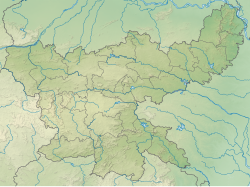
Cities, towns and locations in Ranchi district in South Chotanagpur Division
M: municipality, CT: census town, R: rural/ urban centre, N: neighbourhood, T: tourist centre, D: dam, H: historical/ religious centre
Owing to space constraints in the small map, the actual locations in a larger map may vary slightly

Location

Jonha Falls is located at 23°20′30″N85°36′30″E / 23.34167°N 85.60833°E / 23.34167; 85.60833

Note: The map alongside presents some of the notable locations in the district. All places marked in the map are linked in the larger full screen map. Jonha Fall can be seen without using 722 steps  of stairs via Jonha Fall Resort.

The falls

July 2010. Jonha Jalprapat.jpg
July 2010.

Situated at an edge of the Ranchi plateau, the Jonha Falls is an example of a hanging valley falls. The Gunga River hangs over its master stream, Radu River and forms the falls. [1] One has to descend 722 steps to admire the surroundings. [2] Water in the falls drops from a height of 43 metres (141 ft). [3]

The Jonha Falls is an example of a nick point caused by rejuvenation. Knick point, also called a nick point or simply nick, represents breaks in slopes in the longitudinal profile of a river caused by rejuvenation. The break in channel gradient allows water to fall vertically giving rise to a waterfall. [4]

Culture

There is a tourist rest house which encloses a Buddhist shrine with a deity of Lord Gautama Buddha. [2] A temple and an ashram dedicated to Buddha was built atop Gautam Pahar by the sons of Baldeo Das Birla. [5] A fair is organized in Jonha every Tuesday and Saturday. [2]

Many remains of Buddhism are present in Jonha Falls, situated on Gautam Hill, 38 km away from the capital Ranchi. There is an ancient temple of Lord Gautam Buddha on the hill of Jonha Falls. This temple was built hundreds of years ago by Raja Baldev Das Birla. [6]

Transport

The Jonha Falls is 40 kilometres (25 mi) from Ranchi. It is approachable by both road and train. [7] Jonha Station is just 1.5 km from the fall. For travel by road, one has to take the Ranchi-Purulia Road and after travelling for about 20 miles (32 km) one has to travel about 3 miles (4.8 km) off the main road. [8]

See also

References

  1. Bharatdwaj, K (2006). Physical Geography: Hydrosphere By K. Bharatdwaj. Discovery Publishing House. ISBN   9788183561679 . Retrieved 2 May 2010.
  2. 1 2 3 "Jonha Falls". must see India. Retrieved 29 April 2010.
  3. "High and dry- Dasam drained, Hundru a trickle". The Telegraph 29 April 2009. Archived from the original on 3 February 2013. Retrieved 29 April 2010.
  4. A.Z.Bukhari (2005). Encyclopedia of nature of geography. Anmol Publications Pvt. Limited. ISBN   9788126124435 . Retrieved 11 July 2010.{{cite book}}: |work= ignored (help)[ permanent dead link ]
  5. "Waterfall Around Ranchi". exoticindia. Archived from the original on 8 July 2011. Retrieved 29 April 2010.
  6. "Jonha Falls attracts tourists, Lord Buddha's temple is built near Jonha Falls".
  7. "Johna Falls". Ranchi district administration. Retrieved 29 April 2010.
  8. Sir John Houlton, Bihar, the Heart of India, p. 144, Orient Longmans, 1949

Commons-logo.svg Media related to Jonha Falls at Wikimedia Commons