Related Research Articles

The Chota Nagpur Plateau is a plateau in eastern India, which covers much of Jharkhand state as well as adjacent parts of Chhattisgarh, Odisha, West Bengal and Bihar. The Indo-Gangetic plain lies to the north and east of the plateau, and the basin of the Mahanadi river lies to the south. The total area of the Chota Nagpur Plateau is approximately 65,000 square kilometres (25,000 sq mi).

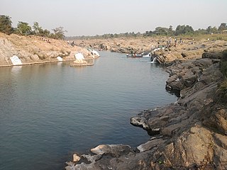
Damodar River is a river flowing across the Indian states of Jharkhand and West Bengal. The valley is rich in mineral resources and is home to large-scale mining and industrial activity. It was also known as the Sorrow of Bengal because of its ravaging floods in the plains of West Bengal. The construction of several dams on the Damodar and its tributaries has helped control some of the flooding.
Dhanbad district is one of the twenty-four districts of Jharkhand state, India, and Dhanbad is the administrative headquarters of this district. As of 2011, it is the second most populous district of Jharkhand, after Ranchi. It also has the lowest sex ratio in Jharkhand, at 908.
Bermo is a community development block that forms an administrative division in the Bermo subdivision of the Bokaro district, Jharkhand state, India.
Petarwar is a community development block that forms an administrative division in the Bermo subdivision of the Bokaro district, Jharkhand state, India.
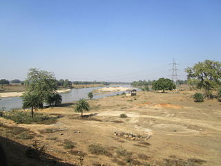
Phusro is a nagar parishad in the Bermo subdivision of the Bokaro district in the Indian state of Jharkhand. It is situated about 35 kilometres (22 mi) from the district headquarters of Bokaro district. Damodar River passes through it.
Damodar Valley Corporation (DVC) is a Government-owned power generator which operates in the Damodar River area of West Bengal and Jharkhand states of India to handle the Damodar Valley Project, the first multipurpose river valley project of independent India. Indian Astrophysicist Meghnad Saha, the former chief architect of river planning in India, prepared the original plan for the Damodar Valley Project. The statutory corporation operates both thermal power stations and hydel power stations under the ownership of Ministry of Power, Government of India. DVC is headquartered in the Kolkata city of West Bengal, India.
The Barakar River is the main tributary of the Damodar River in eastern India. Originating near Padma in Hazaribagh district of Jharkhand it flows for 225 kilometres (140 mi) across the northern part of the Chota Nagpur Plateau, mostly in a west to east direction, before joining the Damodar near Dishergarh in Asansol, Bardhaman district of West Bengal. It has a catchment area of 6,159 square kilometres (2,378 sq mi). The main tributaries, Barsoti and Usri, flow in from the south and north respectively. Apart from the two main tributaries some fifteen medium or small streams join it.
Gomia is a census town in the Gomia CD block in the Bermo subdivision of the Bokaro district in the Indian state of Jharkhand. The modern name is a transformation of Gumia over the years. Though, today, it is still listed as Gumia by the South Eastern Railway (India).
Ramgarh district is one of the 24 districts in the Indian state of Jharkhand. It was also a military district during the British Regime, referred to then as Ramgarh district.

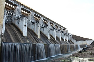
Konar dam is the second of the four multi-purpose dams included in the first phase of the Damodar Valley Corporation. It was constructed across the Konar River, a tributary of the Damodar River in Hazaribagh district in the Indian state of Jharkhand and opened in 1955. The place has scenic beauty and has been developed as a recreational spot.
The Konar River is a tributary of Damodar River in Hazaribagh and Bokaro districts of the Indian state of Jharkhand.
The Mohana River flows through the Hazaribagh, Chatra and Gaya districts in the Indian states of Jharkhand and Bihar.
The Jamunia River is a tributary of the Damodar River. It flows through the Hazaribagh, Giridih, Bokaro and Dhanbad districts in the Indian state of Jharkhand.
Tenughat Dam is an earthfill dam with composite masonry cum concrete spillway across the Damodar River at Tenughat in Petarwar block of Bokaro district in the Indian state of Jharkhand.

Durgapur Barrage is built across the Damodar River at Durgapur in Paschim Bardhaman district and partly in Paschim Bardhaman district, in the Indian state of West Bengal. It was constructed by Damodar Valley Corporation mainly for the purpose of irrigation and also to supply water to Industrial township of Durgapur. The irrigation and canal system was transferred to the Government of West Bengal in 1964.
West Bokaro Coalfield is located mostly in Ramgarh district and partly in Hazaribagh district in the Indian state of Jharkhand.
Mandu (community development block) is an administrative division in the Ramgarh subdivision of the Ramgarh district in the Indian state of Jharkhand.
Nawadih is a village in the Nawadih CD block in the Bermo subdivision of the Bokaro district in the Indian state of Jharkhand.
Bermo subdivision is an administrative subdivision of the Bokaro district in the North Chotanagpur division in the state of Jharkhand, India.
References
- 1 2 Lister, Edward (October 2009). Hazaribagh. ISBN 9781115792776 . Retrieved 3 May 2010.
{{cite book}}:|work=ignored (help) - ↑ "Water pollution in Bokaro River". Supreme Court. Archived from the original on 10 April 2009. Retrieved 3 May 2010.
- ↑ "The real face of the Tatas: a Tata rap sheet" . Retrieved 3 May 2010.
- ↑ "Integrated Flood Management" (PDF). Flood Management – Damodar River Basin. World Metereological Organisation. Archived from the original (PDF) on 7 October 2009. Retrieved 3 May 2010.
| | This article related to a location in Jharkhand is a stub. You can help Wikipedia by expanding it. |