Hydrography

Last updated
Table of geography, hydrography, and navigation, from a 1728 Cyclopaedia. Table of Geography and Hydrography, Cyclopaedia, Volume 1.jpg
Table of geography, hydrography, and navigation, from a 1728 Cyclopaedia .

Hydrography is the branch of applied sciences which deals with the measurement and description of the physical features of oceans, seas, coastal areas, lakes and rivers, as well as with the prediction of their change over time, for the primary purpose of safety of navigation and in support of all other marine activities, including economic development, security and defense, scientific research, and environmental protection. [1]

Contents

History

Alexander Dalrymple, the first Hydrographer of the Navy in the United Kingdom, appointed in 1795. Alexander Dalrymple AGE V07 1801.jpg
Alexander Dalrymple, the first Hydrographer of the Navy in the United Kingdom, appointed in 1795.

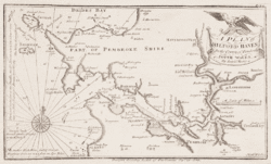
The origins of hydrography lay in the making of charts to aid navigation, by individual mariners as they navigated into new waters. These were usually the private property, even closely held secrets, of individuals who used them for commercial or military advantage. As transoceanic trade and exploration increased, hydrographic surveys started to be carried out as an exercise in their own right, and the commissioning of surveys was increasingly done by governments and special hydrographic offices. National organizations, particularly navies, realized that the collection, systematization and distribution of this knowledge gave it great organizational and military advantages. Thus were born dedicated national hydrographic organizations for the collection, organization, publication and distribution of hydrography incorporated into charts and sailing directions.

Prior to the establishment of the United Kingdom Hydrographic Office, Royal Navy captains were responsible for the provision of their own charts. In practice this meant that ships often sailed with inadequate information for safe navigation, and that when new areas were surveyed, the data rarely reached all those who needed it. The Admiralty appointed Alexander Dalrymple as Hydrographer in 1795, with a remit to gather and distribute charts to HM Ships. Within a year existing charts from the previous two centuries had been collated, and the first catalogue published. [2] The first chart produced under the direction of the Admiralty, was a chart of Quiberon Bay in Brittany, and it appeared in 1800.

Under Captain Thomas Hurd the department received its first professional guidelines, and the first catalogues were published and made available to the public and to other nations as well. In 1829, Rear-Admiral Sir Francis Beaufort, as Hydrographer, developed the eponymous Scale, and introduced the first official tide tables in 1833 and the first "Notices to Mariners" in 1834. The Hydrographic Office underwent steady expansion throughout the 19th century; by 1855, the Chart Catalogue listed 1,981 charts giving a definitive coverage over the entire world, and produced over 130,000 charts annually, of which about half were sold. [3]

The word hydrography comes from the Ancient Greek ὕδωρ (hydor), "water" and γράφω (graphō), "to write".

Overview

Survey of the strategic port of Milford Haven produced by Lewis Morris in 1748 A plan of Milford Haven in the county of Pembroke south Wales.gif
Survey of the strategic port of Milford Haven produced by Lewis Morris in 1748

Large-scale hydrography is usually undertaken by national or international organizations which sponsor data collection through precise surveys and publish charts and descriptive material for navigational purposes. The science of oceanography is, in part, an outgrowth of classical hydrography. In many respects the data are interchangeable, but marine hydrographic data will be particularly directed toward marine navigation and safety of that navigation. Marine resource exploration and exploitation is a significant application of hydrography, principally focused on the search for hydrocarbons.

Hydrographical measurements include the tidal, current and wave information of physical oceanography. They include bottom measurements, with particular emphasis on those marine geographical features that pose a hazard to navigation such as rocks, shoals, reefs and other features that obstruct ship passage. Bottom measurements also include collection of the nature of the bottom as it pertains to effective anchoring. Unlike oceanography, hydrography will include shore features, natural and manmade, that aid in navigation. Therefore, a hydrographic survey may include the accurate positions and representations of hills, mountains and even lights and towers that will aid in fixing a ship's position, as well as the physical aspects of the sea and seabed.

Hydrography, mostly for reasons of safety, adopted a number of conventions that have affected its portrayal of the data on nautical charts. For example, hydrographic charts are designed to portray what is safe for navigation, and therefore will usually tend to maintain least depths and occasionally de-emphasize the actual submarine topography that would be portrayed on bathymetric charts. The former are the mariner's tools to avoid accident. The latter are best representations of the actual seabed, as in a topographic map, for scientific and other purposes. Trends in hydrographic practice since c. 2003–2005 have led to a narrowing of this difference, with many more hydrographic offices maintaining "best observed" databases, and then making navigationally "safe" products as required. This has been coupled with a preference for multi-use surveys, so that the same data collected for nautical charting purposes can also be used for bathymetric portrayal.

HMS Waterwitch, a hydrographic survey vessel HMS Waterwitch, formally Lancashire Witch.jpeg
HMS Waterwitch, a hydrographic survey vessel

Even though, in places, hydrographic survey data may be collected in sufficient detail to portray bottom topography in some areas, hydrographic charts only show depth information relevant for safe navigation and should not be considered as a product that accurately portrays the actual shape of the bottom. The soundings selected from the raw source depth data for placement on the nautical chart are selected for safe navigation and are biased to show predominantly the shallowest depths that relate to safe navigation. For instance, if there is a deep area that can not be reached because it is surrounded by shallow water, the deep area may not be shown. The color filled areas that show different ranges of shallow water are not the equivalent of contours on a topographic map since they are often drawn seaward of the actual shallowest depth portrayed. A bathymetric chart does show marine topology accurately. Details covering the above limitations can be found in Part 1 of Bowditch's American Practical Navigator. Another concept that affects safe navigation is the sparsity of detailed depth data from high resolution sonar systems. In more remote areas, the only available depth information has been collected with lead lines. This collection method drops a weighted line to the bottom at intervals and records the depth, often from a rowboat or sail boat. There is no data between soundings or between sounding lines to guarantee that there is not a hazard such as a wreck or a coral head waiting there to ruin a sailor's day. Often, the navigation of the collecting boat does not match today's GPS navigational accuracies. The hydrographic chart will use the best data available and will caveat its nature in a caution note or in the legend of the chart.

A hydrographic survey is quite different from a bathymetric survey in some important respects, particularly in a bias toward least depths due to the safety requirements of the former and geomorphologic descriptive requirements of the latter. Historically, this could include echosoundings being conducted under settings biased toward least depths, but in modern practice hydrographic surveys typically attempt to best measure the depths observed, with the adjustments for navigational safety being applied after the fact.

Hydrography of streams will include information on the stream bed, flows, water quality and surrounding land. Basin or interior hydrography pays special attention to rivers and potable water although if collected data is not for ship navigational uses, and is intended for scientific usage, it is more commonly called hydrometry or hydrology .

Hydrography of rivers and streams is also an integral part of water management. Most reservoirs in the United States use dedicated stream gauging and rating tables to determine inflows into the reservoir and outflows to irrigation districts, water municipalities and other users of captured water. River/stream hydrographers use handheld and bank mounted devices, to capture a sectional flow rate of moving water through a section and or current.

Equipment

Uncrewed Surface Vessels (USVs) and are commonly used for hydrographic surveys - they are often equipped with some sort of sonar. Single-beam echosounders, multibeam echosounders, and side scan sonars are all frequently used in hydrographic applications. The knowledge gained from these surveys aid in disaster planning, port and harbor maintenance, and various other coastal planning activities. [4] [5]

Organizations

Hydrographic services in most countries are carried out by specialised hydrographic offices. The international coordination of hydrographic efforts lies with the International Hydrographic Organization.

The United Kingdom Hydrographic Office is one of the oldest, supplying a wide range of charts covering the globe to other countries, allied military organisations and the public.

In the United States, the hydrographic charting function has been carried out since 1807 by the Office of Coast Survey of the National Oceanic and Atmospheric Administration within the U.S. Department of Commerce and the U.S. Army Corps of Engineers. [6] [7]

See also

Associations focussing on ocean hydrography
Associations focussing on river stream and lake hydrography

Related Research Articles

<span class="mw-page-title-main">Challenger Deep</span> Deepest-known point of Earths seabed

The Challenger Deep is the deepest known point of the seabed of Earth, located in the western Pacific Ocean at the southern end of the Mariana Trench, in the ocean territory of the Federated States of Micronesia. According to the GEBCO Gazetteer of Undersea Feature Names the depression's depth is 10,920 ± 10 m (35,827 ± 33 ft) at 11°22.4′N142°35.5′E, although its exact geodetic location remains inconclusive and its depth has been measured at 10,902–10,929 m (35,768–35,856 ft) by deep-diving submersibles, remotely operated underwater vehicles, benthic landers, and sonar bathymetry. The differences in depth estimates and their geodetic positions are scientifically explainable by the difficulty of researching such deep locations.

<span class="mw-page-title-main">International Hydrographic Organization</span> Intergovernmental organization

The International Hydrographic Organization (IHO) is an intergovernmental organisation representing hydrography. As of November 2023, the IHO comprised 99 Member States.

<span class="mw-page-title-main">Echo sounding</span> Measuring the depth of water by transmitting sound waves into water and timing the return

Echo sounding or depth sounding is the use of sonar for ranging, normally to determine the depth of water (bathymetry). It involves transmitting acoustic waves into water and recording the time interval between emission and return of a pulse; the resulting time of flight, along with knowledge of the speed of sound in water, allows determining the distance between sonar and target. This information is then typically used for navigation purposes or in order to obtain depths for charting purposes.

<span class="mw-page-title-main">Hydrographic survey</span> Science of measurement and description of features which affect maritime activities

Hydrographic survey is the science of measurement and description of features which affect maritime navigation, marine construction, dredging, offshore wind farms, offshore oil exploration and drilling and related activities. Surveys may also be conducted to determine the route of subsea cables such as telecommunications cables, cables associated with wind farms, and HVDC power cables. Strong emphasis is placed on soundings, shorelines, tides, currents, seabed and submerged obstructions that relate to the previously mentioned activities. The term hydrography is used synonymously to describe maritime cartography, which in the final stages of the hydrographic process uses the raw data collected through hydrographic survey into information usable by the end user.

A hydrographic office is an organization which is devoted to acquiring and publishing hydrographic information.

<span class="mw-page-title-main">Bathymetric chart</span> Map depicting the submerged terrain of bodies of water

A bathymetric chart is a type of isarithmic map that depicts the submerged topography and physiographic features of ocean and sea bottoms. Their primary purpose is to provide detailed depth contours of ocean topography as well as provide the size, shape and distribution of underwater features. Topographic maps display elevation above ground and are complementary to bathymetric charts. Charts use a series of lines and points at equal intervals to showcase depth or elevation. A closed shape with increasingly smaller shapes inside of it can indicate an ocean trench or a seamount, or underwater mountain, depending on whether the depths increase or decrease going inward.

<span class="mw-page-title-main">Canadian Hydrographic Service</span> Part of the federal department of Fisheries and Oceans Canada

The Canadian Hydrographic Service (CHS) is part of the federal department of Fisheries and Oceans Canada and is Canada's authoritative hydrographic office. The CHS represents Canada in the International Hydrographic Organization (IHO).

<span class="mw-page-title-main">Bathymetry</span> Study of underwater depth of lake or ocean floors

Bathymetry is the study of underwater depth of ocean floors, lake floors, or river floors. In other words, bathymetry is the underwater equivalent to hypsometry or topography. The first recorded evidence of water depth measurements are from Ancient Egypt over 3000 years ago. Bathymetric charts, are typically produced to support safety of surface or sub-surface navigation, and usually show seafloor relief or terrain as contour lines and selected depths (soundings), and typically also provide surface navigational information. Bathymetric maps may also use a Digital Terrain Model and artificial illumination techniques to illustrate the depths being portrayed. The global bathymetry is sometimes combined with topography data to yield a global relief model. Paleobathymetry is the study of past underwater depths.

<span class="mw-page-title-main">Survey vessel</span> Type of research vessel

A survey vessel is any type of ship or boat that is used for underwater surveys, usually to collect data for mapping or planning underwater construction or mineral extraction. It is a type of research vessel, and may be designed for the purpose, modified for the purpose or temporarily put into the service as a vessel of opportunity, and may be crewed, remotely operated, or autonomous. The size and equipment vary to suit the task and availability.

<span class="mw-page-title-main">United Kingdom Hydrographic Office</span> UK government agency concerned with providing hydrographic and marine geospatial data

The United Kingdom Hydrographic Office (UKHO) is the UK's agency for providing hydrographic and marine geospatial data to mariners and maritime organisations across the world. The UKHO is a trading fund of the Ministry of Defence (MoD) and is located in Taunton, Somerset, with a workforce of approximately 900 staff.

<span class="mw-page-title-main">Marine geology</span> Study of the history and structure of the ocean floor

Marine geology or geological oceanography is the study of the history and structure of the ocean floor. It involves geophysical, geochemical, sedimentological and paleontological investigations of the ocean floor and coastal zone. Marine geology has strong ties to geophysics and to physical oceanography.

<span class="mw-page-title-main">Admiralty chart</span> Nautical chart

Admiralty charts are nautical charts issued by the United Kingdom Hydrographic Office (UKHO) and subject to Crown Copyright. Over 3,500 Standard Nautical Charts (SNCs) and 14,000 Electronic Navigational Charts (ENCs) are available with the Admiralty portfolio offering the widest official coverage of international shipping routes and ports, in varying detail.

The Danish Maritime Safety Administration (DaMSA) was a department of the Danish Ministry of Defence with administration located in Christianshavn, Copenhagen. DaMSA operated throughout Denmark as part of the Danish Search and Rescue (SAR) organization that runs 21 rescue stations located along the coasts of Denmark.

The Naval Oceanographic Office (NAVOCEANO), located at John C. Stennis Space Center in south Mississippi, is an echelon IV component of the Naval Meteorology and Oceanography Command (NMOC) and comprises approximately 1,000 civilian, military and contract personnel responsible for providing oceanographic products and services to all elements within the Department of Defense.

NOAAS <i>Thomas Jefferson</i>

NOAAS Thomas Jefferson is a National Oceanic and Atmospheric Administration (NOAA) hydrographic survey vessel in service since 2003. The ship was built for the United States Navy as USNS Littlehales (T-AGS-52) serving as one of two new coastal hydrographic survey vessels from 1992 until transfer to NOAA in 2003 when it was named after Founding Father and third U.S. president, Thomas Jefferson.

<span class="mw-page-title-main">Russian Hydrographic Service</span>

The Russian Hydrographic Service, full current official name Department of Navigation and Oceanography of the Ministry of Defence of the Russian Federation, is Russia's hydrographic office, with responsibility to facilitate navigation, performing hydrographic surveys and publishing nautical charts.

<span class="mw-page-title-main">Vertical Offshore Reference Frames</span> UK and Irish hydrographic vertical datum

Vertical Offshore Reference Frames (VORF) is a set of high resolution surface models, published and maintained by the UK Hydrographic Office, which together define a vertical datum for hydrographic surveying and charting in the United Kingdom and Ireland.

The Hydrographic Institute of the Republic of Croatia is a government agency responsible for providing hydrographic and marine geospatial data for the Republic of Croatia. The institute is located in Split, and covers scientific research and development, services related to the safety of navigation, the hydrographic-geodetic survey of the Adriatic sea, marine geodesy, design and publication of nautical charts and books, oceanographic research, and submarine geology research. The Croatian Hydrographic Institute is responsible for the development of navigational safety service in the Adriatic, within the worldwide navigational safety system, and in cooperation with the Ministry of the Sea, Transport and Infrastructure, port authorities, the Croatian Navy, lighthouse authorities, and hydrographic offices of all maritime countries, following internationally agreed standards.

<span class="mw-page-title-main">Underwater survey</span> Inspection or measurement in or of an underwater environment

An underwater survey is a survey performed in an underwater environment or conducted remotely on an underwater object or region. Survey can have several meanings. The word originates in Medieval Latin with meanings of looking over and detailed study of a subject. One meaning is the accurate measurement of a geographical region, usually with the intention of plotting the positions of features as a scale map of the region. This meaning is often used in scientific contexts, and also in civil engineering and mineral extraction. Another meaning, often used in a civil, structural, or marine engineering context, is the inspection of a structure or vessel to compare actual condition with the specified nominal condition, usually with the purpose of reporting on the actual condition and compliance with, or deviations from, the nominal condition, for quality control, damage assessment, valuation, insurance, maintenance, and similar purposes. In other contexts it can mean inspection of a region to establish presence and distribution of specified content, such as living organisms, either to establish a baseline, or to compare with a baseline.

<span class="mw-page-title-main">Underwater exploration</span> Investigating or traveling around underwater for the purpose of discovery

Underwater exploration is the exploration of any underwater environment, either by direct observation by the explorer, or by remote observation and measurement under the direction of the investigators. Systematic, targeted exploration is the most effective method to increase understanding of the ocean and other underwater regions, so they can be effectively managed, conserved, regulated, and their resources discovered, accessed, and used. Less than 10% of the ocean has been mapped in any detail, less has been visually observed, and the total diversity of life and distribution of populations is similarly obscure.

References

  1. "International Hydrographic Organization". Archived from the original on 2014-07-24. Retrieved 2013-10-20.
  2. "The United Kingdom Hydrographic Office timeline" (PDF). UKHO. Archived from the original (PDF) on 2011-07-21. Retrieved 2011-01-23.
  3. "Charting the world for over 200 years". www.ukho.gov.uk. UKHO. Archived from the original on 2006-09-25. Retrieved 2006-11-15.
  4. US Department of Commerce, National Oceanic and Atmospheric Administration. "Hydrographic Surveying". oceanservice.noaa.gov. Retrieved 2024-01-12.
  5. "A Smooth Operator's Guide to Underwater Sonars and Acoustic Devices". Blue Robotics. Retrieved 2024-01-12.
  6. "About Inland Survey".
  7. "About Coast Survey".