Benthic zone

Last updated • 8 min readFrom Wikipedia, The Free Encyclopedia
Photomicrograph of typical benthic animals, including (from top to bottom) amphipods, a polychaete worm, a snail, and a chironomous midge larva Benthic GLERL 1.jpg
Photomicrograph of typical benthic animals, including (from top to bottom) amphipods, a polychaete worm, a snail, and a chironomous midge larva

The benthic zone is the ecological region at the lowest level of a body of water such as an ocean, lake, or stream, including the sediment surface and some sub-surface layers. The name comes from the Ancient Greek word βένθος (bénthos), meaning "the depths". [1] Organisms living in this zone are called benthos and include microorganisms (e.g., bacteria and fungi) [2] [3] as well as larger invertebrates, such as crustaceans and polychaetes. [4]

Contents

Organisms here, known as bottom dwellers, generally live in close relationship with the substrate and many are permanently attached to the bottom. The benthic boundary layer, which includes the bottom layer of water and the uppermost layer of sediment directly influenced by the overlying water, is an integral part of the benthic zone, as it greatly influences the biological activity that takes place there. Examples of contact soil layers include sand bottoms, rocky outcrops, coral, and bay mud.

Description

Oceans

The benthic region of the ocean begins at the shore line (intertidal or littoral zone) and extends downward along the surface of the continental shelf out to sea. Thus, the region incorporates a great variety of physical conditions differing in: depth, light penetration and pressure. [5] Depending on the water-body, the benthic zone may include areas that are only a few inches below the surface.

The continental shelf is a gently sloping benthic region that extends away from the land mass. At the continental shelf edge, usually about 200 metres (660 ft) deep, the gradient greatly increases and is known as the continental slope. The continental slope drops down to the deep sea floor. The deep-sea floor is called the abyssal plain and is usually about 4,000 metres (13,000 ft) deep. The ocean floor is not all flat but has submarine ridges and deep ocean trenches known as the hadal zone. [6] For comparison, the pelagic zone is the descriptive term for the ecological region above the benthos, including the water column up to the surface. At the other end of the spectrum, benthos of the deep ocean includes the bottom levels of the oceanic abyssal zone. [7]

For information on animals that live in the deeper areas of the oceans see aphotic zone. Generally, these include life forms that tolerate cool temperatures and low oxygen levels, but this depends on the depth of the water. [8]

Lakes

As with oceans, the benthic zone is the floor of the lake, composed of accumulated sunken organic matter. The littoral zone is the zone bordering the shore; light penetrates easily and aquatic plants thrive. The pelagic zone represents the broad mass of water, down as far as the depth to which no light penetrates. [9]

Organisms

Benthos are the organisms that live in the benthic zone, and are different from those elsewhere in the water column; even within the benthic zone variations in such factors as light penetration, temperature and salinity give rise to distinct differences, delineated vertically, in the groups of organisms supported. [10] Many organisms adapted to deep-water pressure cannot survive in the upper parts of the water column: the pressure difference can be very significant (approximately one atmosphere for each 10 meters of water depth). Many have adapted to live on the substrate (bottom). In their habitats they can be considered as dominant creatures, but they are often a source of prey for Carcharhinidae such as the lemon shark. [11]

Because light does not penetrate very deep into ocean-water, the energy source for the benthic ecosystem is often marine snow. Marine snow is organic matter from higher up in the water column that drifts down to the depths. [12] This dead and decaying matter sustains the benthic food chain; most organisms in the benthic zone are scavengers or detritivores. Some microorganisms use chemosynthesis to produce biomass.

Benthic organisms can be divided into two categories based on whether they make their home on the ocean floor or a few centimeters into the ocean floor. Those living on the surface of the ocean floor are known as epifauna. [13] Those who live burrowed into the ocean floor are known as infauna. [10] Extremophiles, including piezophiles, which thrive in high pressures, may also live there. An example of benthos organism is Chorismus antarcticus.

Nutrient flux

Sources of food for benthic communities can derive from the water column above these habitats in the form of aggregations of detritus, inorganic matter, and living organisms. [14] These aggregations are commonly referred to as marine snow, and are important for the deposition of organic matter, and bacterial communities. [15] The amount of material sinking to the ocean floor can average 307,000 aggregates per m2 per day. [16] This amount will vary on the depth of the benthos, and the degree of benthic-pelagic coupling. The benthos in a shallow region will have more available food than the benthos in the deep sea. Because of their reliance on it, microbes may become spatially dependent on detritus in the benthic zone. The microbes found in the benthic zone, specifically dinoflagellates and foraminifera, colonize quite rapidly on detritus matter while forming a symbiotic relationship with each other. [17] [18] In the deep sea, which covers 90–95% of the ocean floor, 90% of the total biomass is made up of prokaryotes. To release all the nutrients locked inside these microbes to the environment, viruses are important in making it available to other organisms. [19] [20]

Habitats

Modern seafloor mapping technologies have revealed linkages between seafloor geomorphology and benthic habitats, in which suites of benthic communities are associated with specific geomorphic settings. [21] Examples include cold-water coral communities associated with seamounts and submarine canyons, kelp forests associated with inner shelf rocky reefs and rockfish associated with rocky escarpments on continental slopes. [22] In oceanic environments, benthic habitats can also be zoned by depth. From the shallowest to the deepest are: the epipelagic (less than 200 meters), the mesopelagic (200–1,000 meters), the bathyal (1,000–4,000 meters), the abyssal (4,000–6,000 meters) and the deepest, the hadal (below 6,000 meters). [23]

The lower zones are in deep, pressurized areas of the ocean. Human impacts have occurred at all ocean depths, but are most significant on shallow continental shelf and slope habitats. [24] Many benthic organisms have retained their historic evolutionary characteristics. Some organisms are significantly larger than their relatives living in shallower zones, largely because of higher oxygen concentration in deep water. [25]

It is not easy to map or observe these organisms and their habitats, and most modern observations are made using remotely operated underwater vehicles (ROVs), and rarely submarines. [26] [27]

Ecological research

Benthic macroinvertebrates have many important ecological functions, such as regulating the flow of materials and energy in river ecosystems through their food web linkages. Because of this correlation between flow of energy and nutrients, benthic macroinvertebrates have the ability to influence food resources on fish and other organisms in aquatic ecosystems. For example, the addition of a moderate amount of nutrients to a river over the course of several years resulted in increases in invertebrate richness, abundance, and biomass. These in turn resulted in increased food resources for native species of fish with insignificant alteration of the macroinvertebrate community structure and trophic pathways. [28] The presence of macroinvertebrates such as Amphipoda also affect the dominance of certain types of algae in Benthic ecosystems as well. [29] In addition, because benthic zones are influenced by the flow of dead organic material, there have been studies conducted on the relationship between stream and river water flows and the resulting effects on the benthic zone. Low flow events show a restriction in nutrient transport from benthic substrates to food webs, and caused a decrease in benthic macroinvertebrate biomass, which lead to the disappearance of food sources into the substrate. [30]

Because the benthic system regulates energy in aquatic ecosystems, studies have been made of the mechanisms of the benthic zone in order to better understand the ecosystem. Benthic diatoms have been used by the European Union's Water Framework Directive (WFD) to establish ecological quality ratios that determined the ecological status of lakes in the UK. [31] Beginning research is being made on benthic assemblages to see if they can be used as indicators of healthy aquatic ecosystems. Benthic assemblages in urbanized coastal regions are not functionally equivalent to benthic assemblages in untouched regions. [32]

Ecologists are attempting to understand the relationship between heterogeneity and maintaining biodiversity in aquatic ecosystems. Benthic algae has been used as an inherently good subject for studying short term changes and community responses to heterogeneous conditions in streams. Understanding the potential mechanisms involving benthic periphyton and the effects on heterogeneity within a stream may provide a better understanding of the structure and function of stream ecosystems. [33] Periphyton populations suffer from high natural spatial variability while difficult accessibility simultaneously limits the practicable number of samples that can be taken. Targeting periphyton locations which are known to provide reliable samples especially hard surfaces is recommended in the European Union benthic monitoring program (by Kelly 1998 for the United Kingdom then in the EU and for the EU as a whole by CEN 2003 and CEN 2004) and in some United States programs (by Moulton et al. 2002). [34] :60 Benthic gross primary production (GPP) may be important in maintaining biodiversity hotspots in littoral zones in large lake ecosystems. However, the relative contributions of benthic habitats within specific ecosystems are poorly explored and more research is planned. [35]

See also

Related Research Articles

<span class="mw-page-title-main">Benthos</span> Community of organisms that live in the benthic zone

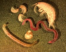
Benthos, also known as benthon, is the community of organisms that live on, in, or near the bottom of a sea, river, lake, or stream, also known as the benthic zone. This community lives in or near marine or freshwater sedimentary environments, from tidal pools along the foreshore, out to the continental shelf, and then down to the abyssal depths.

The pelagic zone consists of the water column of the open ocean and can be further divided into regions by depth. The word pelagic is derived from Ancient Greek πέλαγος (pélagos) 'open sea'. The pelagic zone can be thought of as an imaginary cylinder or water column between the surface of the sea and the bottom. Conditions in the water column change with depth: pressure increases; temperature and light decrease; salinity, oxygen, micronutrients all change. In a manner analogous to stratification in the Earth's atmosphere, the water column can be divided vertically into up to five different layers, with the number of layers depending on the depth of the water.

<span class="mw-page-title-main">Littoral zone</span> Part of a sea, lake, or river that is close to the shore

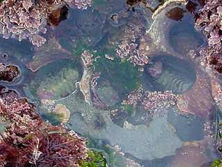
The littoral zone, also called litoral or nearshore, is the part of a sea, lake, or river that is close to the shore. In coastal ecology, the littoral zone includes the intertidal zone extending from the high water mark, to coastal areas that are permanently submerged — known as the foreshore — and the terms are often used interchangeably. However, the geographical meaning of littoral zone extends well beyond the intertidal zone to include all neritic waters within the bounds of continental shelves.

<span class="mw-page-title-main">Bottom trawling</span> Fishing method by towing a net along the seafloor

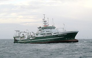
Bottom trawling is trawling along the seafloor. It is also referred to as "dragging". The scientific community divides bottom trawling into benthic trawling and demersal trawling. Benthic trawling is towing a net at the very bottom of the ocean and demersal trawling is towing a net just above the benthic zone. Bottom trawling can be contrasted with midwater trawling, where a net is towed higher in the water column. Midwater trawling catches pelagic fish such as anchovies and mackerel, whereas bottom trawling targets both bottom-living fish (groundfish) and semi-pelagic species such as cod, squid, shrimp, and rockfish.

<span class="mw-page-title-main">Seabed</span> The bottom of an ocean

The seabed is the bottom of the ocean. All floors of the ocean are known as 'seabeds'.

The abyssal zone or abyssopelagic zone is a layer of the pelagic zone of the ocean. The word abyss comes from the Greek word ἄβυσσος (ábussos), meaning "bottomless". At depths of 4,000–6,000 m (13,000–20,000 ft), this zone remains in perpetual darkness. It covers 83% of the total area of the ocean and 60% of Earth's surface. The abyssal zone has temperatures around 2–3 °C (36–37 °F) through the large majority of its mass. The water pressure can reach up to 76 MPa.

<span class="mw-page-title-main">Pulley Ridge</span>

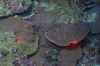
Pulley Ridge is a mesophotic coral reef system off the shores of the continental United States. The reef rests on sunken barrier islands and lies 100 miles west of the Tortugas Ecological Reserve and stretches north about 60 miles at depths ranging from 60 to 80 meters. Pulley Ridge was originally discovered in 1950 during a dredging operation conducted by an academic group from Texas. While well known to fishermen, this remarkable habitat remained undiscovered by scientists until 1999 when the U.S. Geological Survey (USGS) and graduate students from the University of South Florida happened upon it. This reef system, like other mesophotic ecosystems, is inhabited by photosynthesizing corals and algae that are adapted to low-light environments. It is habitat for numerous species of bottom fish including Epinephelus morio spawning area.

<span class="mw-page-title-main">Pelagic fish</span> Fish in the pelagic zone of ocean waters

Pelagic fish live in the pelagic zone of ocean or lake waters—being neither close to the bottom nor near the shore—in contrast with demersal fish that live on or near the bottom, and reef fish that are associated with coral reefs.

<span class="mw-page-title-main">Demersal fish</span> Fish that live and feed on or near the bottom of seas or lakes

Demersal fish, also known as groundfish, live and feed on or near the bottom of seas or lakes. They occupy the sea floors and lake beds, which usually consist of mud, sand, gravel or rocks. In coastal waters, they are found on or near the continental shelf, and in deep waters, they are found on or near the continental slope or along the continental rise. They are not generally found in the deepest waters, such as abyssal depths or on the abyssal plain, but they can be found around seamounts and islands. The word demersal comes from the Latin demergere, which means to sink.

<span class="mw-page-title-main">Lord Howe Rise</span> Deep sea plateau from south west of New Caledonia to the Challenger Plateau, west of New Zealand

The Lord Howe Rise is a deep sea plateau which extends from south west of New Caledonia to the Challenger Plateau, west of New Zealand in the south west of the Pacific Ocean. To its west is the Tasman Basin and to the east is the New Caledonia Basin. Lord Howe Rise has a total area of about 1,500,000 km2 (580,000 sq mi), and generally lies about 750 to 1,200 metres under water. It is part of Zealandia, a much larger continent that is now mostly submerged, and so is composed of continental crust. Some have included the 3,500 m (11,500 ft) deep New Caledonia Basin as within the rise, given its continental crust origin, and this would give a larger total area of 1,950,000 km2 (750,000 sq mi).

<span class="mw-page-title-main">Marine ecosystem</span> Ecosystem in saltwater environment

Marine ecosystems are the largest of Earth's aquatic ecosystems and exist in waters that have a high salt content. These systems contrast with freshwater ecosystems, which have a lower salt content. Marine waters cover more than 70% of the surface of the Earth and account for more than 97% of Earth's water supply and 90% of habitable space on Earth. Seawater has an average salinity of 35 parts per thousand of water. Actual salinity varies among different marine ecosystems. Marine ecosystems can be divided into many zones depending upon water depth and shoreline features. The oceanic zone is the vast open part of the ocean where animals such as whales, sharks, and tuna live. The benthic zone consists of substrates below water where many invertebrates live. The intertidal zone is the area between high and low tides. Other near-shore (neritic) zones can include mudflats, seagrass meadows, mangroves, rocky intertidal systems, salt marshes, coral reefs, lagoons. In the deep water, hydrothermal vents may occur where chemosynthetic sulfur bacteria form the base of the food web.

<span class="mw-page-title-main">Marine sediment</span> Accumulated material on seafloor

Marine sediment, or ocean sediment, or seafloor sediment, are deposits of insoluble particles that have accumulated on the seafloor. These particles either have their origins in soil and rocks and have been transported from the land to the sea, mainly by rivers but also by dust carried by wind and by the flow of glaciers into the sea, or they are biogenic deposits from marine organisms or from chemical precipitation in seawater, as well as from underwater volcanoes and meteorite debris.

<span class="mw-page-title-main">Integrated Marine and Coastal Regionalisation of Australia</span> Regionalisation of oceanic waters of Australia

The Integrated Marine and Coastal Regionalisation of Australia (IMCRA), formerly the Interim Marine and Coastal Regionalisation for Australia, is a biogeographic regionalisation of the oceanic waters of Australia's exclusive economic zone (EEZ). As of 2008, the most recent version is IMCRA Version 4.0.

This is a glossary of terms used in fisheries, fisheries management and fisheries science.

<span class="mw-page-title-main">Deep-sea community</span> Groups of organisms living deep below the sea surface, sharing a habitat

A deep-sea community is any community of organisms associated by a shared habitat in the deep sea. Deep sea communities remain largely unexplored, due to the technological and logistical challenges and expense involved in visiting this remote biome. Because of the unique challenges, it was long believed that little life existed in this hostile environment. Since the 19th century however, research has demonstrated that significant biodiversity exists in the deep sea.

The benthic boundary layer (BBL) is the layer of water directly above the sediment at the bottom of a body of water. Through specific sedimentation processes, certain organisms are able to live in this deep layer of water. The BBL is generated by the friction of the water moving over the surface of the substrate, which decrease the water current significantly in this layer. The thickness of this zone is determined by many factors, including the Coriolis force. The benthic organisms and processes in this boundary layer echo the water column above them.

<span class="mw-page-title-main">Marine habitat</span> Habitat that supports marine life

A marine habitat is a habitat that supports marine life. Marine life depends in some way on the saltwater that is in the sea. A habitat is an ecological or environmental area inhabited by one or more living species. The marine environment supports many kinds of these habitats.

<span class="mw-page-title-main">Jelly-falls</span> Marine carbon cycling events whereby gelatinous zooplankton sink to the seafloor

Jelly-falls are marine carbon cycling events whereby gelatinous zooplankton, primarily cnidarians, sink to the seafloor and enhance carbon and nitrogen fluxes via rapidly sinking particulate organic matter. These events provide nutrition to benthic megafauna and bacteria. Jelly-falls have been implicated as a major “gelatinous pathway” for the sequestration of labile biogenic carbon through the biological pump. These events are common in protected areas with high levels of primary production and water quality suitable to support cnidarian species. These areas include estuaries and several studies have been conducted in fjords of Norway.

<span class="mw-page-title-main">Aquatic sill</span> A sea floor barrier of relatively shallow depth restricting water movement between oceanic basins

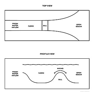
An aquatic sill is a sea floor barrier of relatively shallow depth that restricts water movement between benthic zones of an oceanic basin or lake bottom. There are roughly 400 sills in the Earth's oceans, covering 0.01% of the seafloor. A classic example is the Strait of Gibraltar Gateway between the Mediterranean sea and the Atlantic Ocean.

<span class="mw-page-title-main">Benthic-pelagic coupling</span> Processes that connect the benthic and pelagic zones of a body of water

Benthic-pelagic coupling are processes that connect the benthic zone and the pelagic zone through the exchange of energy, mass, or nutrients. These processes play a prominent role in both freshwater and marine ecosystems and are influenced by a number of chemical, biological, and physical forces that are crucial to functions from nutrient cycling to energy transfer in food webs.

References

  1. Wiktionary-logo-en-v2.svg The dictionary definition of benthos at Wiktionary
  2. Wetzel, Robert G. (2001). Limnology: Lake and River Ecosystems, 3rd edn. Academic Press, San Diego. pp. 635–637.
  3. Fenchel, T.; King, G.; Blackburn, T. H. (2012). Bacterial Biogeochemistry: The Ecophysiology of Mineral Cycling, 3rd edn. Academic Press, London. pp. 121–122.
  4. "What Are Benthos?". Baybenthos.versar.com. 2006-01-23. Retrieved 2013-11-24.
  5. Walag, Angelo (2022). "Understanding the world of Benthos: an introduction to Benthology". In Godson, Prince; et al. (eds.). Ecology and Biodiversity of Benthos. Amsterdam, Netherlands: Elsevier. p. 1. ISBN   9780128211618.
  6. Nichols, C. Reid; Williams, Robert G. (2009). "hadal zone". Encyclopedia of marine science. New York: Infobase. ISBN   9781438118819.
  7. Nichols, Williams (2009): "abyssal zone"
  8. Nichols, Williams (2009): "aphotic zone"
  9. Silk, Nicole; Ciruna, Kristine (2005). A practitioner's guide to freshwater biodiversity conservation. Washington, DC: Island Press. ISBN   9781597260435.
  10. 1 2 Walag (2022) p.2
  11. Bright, Michael (2000). The private life of sharks: the truth behind the myth. Mechanicsburg, Pennsylvania: Stackpole Books. ISBN   0-8117-2875-7.
  12. Matthiessen, Berte (2018). "Ecological Organization of the Ocean". In Salomon, Markus; et al. (eds.). Handbook on Marine Environment Protection. Berlin: Springer. p. 53. ISBN   978-3-319-60154-0.
  13. "Epifaunal - Definition and More from the Free Merriam-Webster Dictionary". Merriam-webster.com. 2012-08-31. Retrieved 2013-11-24.
  14. Godson (2022) p.90
  15. Alldredge, Alice; Silver, Mary W. (1988). "Characteristics, dynamics and significance of marine snow". Progress in Oceanography. 20 (1): 41–82. Bibcode:1988PrOce..20...41A. doi:10.1016/0079-6611(88)90053-5.
  16. Shanks, Alan; Trent, Jonathan D. (1980). "Marine snow: sinking rates and potential role in vertical flux". Deep-Sea Research. 27A (2): 137–143. Bibcode:1980DSRA...27..137S. doi:10.1016/0198-0149(80)90092-8.
  17. "Foraminifera" . Retrieved 7 December 2014.
  18. "foraminifera" . Retrieved 7 December 2014.
  19. Seaborg, David (30 June 2023). Organisms Amplify Diversity: An Autocatalytic Hypothesis. CRC Press. ISBN   978-1-000-82638-8.
  20. Danovaro, R.; Molari, M.; Corinaldesi, C.; Dell'Anno, A. (2016). "Macroecological drivers of archaea and bacteria in benthic deep-sea ecosystems". Science Advances. 2 (4): e1500961. Bibcode:2016SciA....2E0961D. doi:10.1126/sciadv.1500961. PMC   4928989 . PMID   27386507.
  21. Harris, P. T.; Baker, E. K. 2012. "GEOHAB Atlas of seafloor geomorphic features and benthic habitats – synthesis and lessons learned", in: Harris, P. T.; Baker, E. K. (eds.), Seafloor Geomorphology as Benthic Habitat: GeoHab Atlas of seafloor geomorphic features and benthic habitats. Elsevier, Amsterdam, pp. 871–890.
  22. Harris, P. T.; Baker, E. K.; 2012. Seafloor Geomorphology as Benthic Habitat: GeoHab Atlas of seafloor geomorphic features and benthic habitats. Elsevier, Amsterdam, p. 947.
  23. "Coastal and Marine Ecological Classification Standard (CMECS)". 2012.{{cite journal}}: Cite journal requires |journal= (help)
  24. Harris, P. T., 2012. "Anthropogenic threats to benthic habitats", in: Harris, P. T.; Baker, E. K. (eds.), Seafloor Geomorphology as Benthic Habitat: GeoHab Atlas of seafloor geomorphic features and benthic habitats. Elsevier, Amsterdam, pp. 39–60.
  25. Royal Belgian Institute of Natural Sciences, news item March 2005 Archived September 28, 2011, at the Wayback Machine
  26. Clark, Malcolm; et al. (2016). Biological sampling in the deep sea. Hoboken, New Jersey: Wiley. p. 30. ISBN   9781118332559.
  27. Tillin, H. M.; et al. "Marine Monitoring Platform Guidelines: Remotely Operated Vehicles for use in marine benthic monitoring" (PDF). Peterborough, UK: Joint Nature Conservation Committee. p. 1. Retrieved 15 June 2022.
  28. Minshall, Wayne; Shafii, Bahman; Price, William J.; Holderman, Charlie; Anders, Paul J.; Lester, Gary; Barrett, Pat (2014). "Effects of nutrient replacement on benthic macroinvertebrates in an ultraoligotrophic reach of the Kootenai River, 2003–2010". Freshwater Science. 33 (4): 1009–1023. doi: 10.1086/677900 . JSTOR   10.1086/677900. S2CID   84495019.
  29. Duffy, J. Emmett; Hay, Mark E. (2000-05-01). "Strong impacts of grazing amphipods on the organization of a benthic community". Ecological Monographs. 70 (2): 237–263. CiteSeerX   10.1.1.473.4746 . doi:10.1890/0012-9615(2000)070[0237:SIOGAO]2.0.CO;2. ISSN   0012-9615. S2CID   54598097.
  30. Rolls, Robert; Leigh, Catherine; Sheldon, Fran (2012). "Mechanistic effects of low-flow hydrology on riverine ecosystems: ecological principles and consequences of alteration". Freshwater Science. 31 (4): 1163–1186. doi:10.1899/12-002.1. hdl: 10072/48539 . JSTOR   10.1899/12-002.1. S2CID   55593045.
  31. Bennion, Helen; Kelly, Martyn G.; Juggins, Steve; Yallop, Marian L.; Burgess, Amy; Jamieson, Jane; Krokowski, Jan (2014). "Assessment of Ecological Status in UK lakes using benthic diatoms" (PDF). Freshwater Science. 33 (2): 639–654. doi:10.1086/675447. JSTOR   10.1086/675447. S2CID   33631675.
  32. Lowe, Michael; Peterson, Mark S. (2014). "Effects of Coastal Urbanization on Salt-Marsh Faunal Assemblages in the Northern Gulf of Mexico". Marine and Coastal Fisheries: Dynamics, Management, and Ecosystem Science. 6: 89–107. doi: 10.1080/19425120.2014.893467 . hdl: 1912/6981 .
  33. Wellnitz, Todd; Rader, Russell B. (2003). "Mechanisms influencing community composition and succession in mountain stream periphyton: interactions between scouring history, grazing, and irradiance". Journal of the North American Benthological Society. 22 (4): 528–541. doi:10.2307/1468350. JSTOR   1468350. S2CID   85061936.
  34. Smol, John P. (2010). The Diatoms: Applications for the Environmental and Earth Sciences. Cambridge New York City: Cambridge University Press (CUP). ISBN   978-0-521-50996-1. OCLC   671782244.
  35. Althouse, Bryan; Higgins, Scott; Vander Zanden, Jake M. (2014). "Benthic and Planktonic primary production along a nutrient gradient in Green Bay, Lake Michigan, USA". Freshwater Science. 33 (2): 487–498. doi: 10.1086/676314 . JSTOR   10.1086/676314. S2CID   84535584.