Related Research Articles

Downwelling is the process of accumulation and sinking of higher density material beneath lower density material, such as cold or saline water beneath warmer or fresher water or cold air beneath warm air. It is the sinking limb of a convection cell. Upwelling is the opposite process, and together, these two forces are responsible in the oceans for the thermohaline circulation. The sinking of the cold lithosphere at subduction zones is another example of downwelling in plate tectonics.

Upwelling is an oceanographic phenomenon that involves wind-driven motion of dense, cooler, and usually nutrient-rich water from deep water towards the ocean surface. It replaces the warmer and usually nutrient-depleted surface water. The nutrient-rich upwelled water stimulates the growth and reproduction of primary producers such as phytoplankton. The biomass of phytoplankton and the presence of cool water in those regions allow upwelling zones to be identified by cool sea surface temperatures (SST) and high concentrations of chlorophyll-a.

Panthalassa, also known as the Panthalassic Ocean or Panthalassan Ocean, was the superocean that surrounded the supercontinent Pangaea, the latest in a series of supercontinents in the history of Earth. During the Paleozoic–Mesozoic transition c. 250 Ma it occupied almost 70% of Earth's surface. Its ocean floor has completely disappeared because of the continuous subduction along the continental margins on its circumference. Panthalassa is also referred to as the Paleo-Pacific or Proto-Pacific because the Pacific Ocean is a direct continuation of Panthalassa.

An ocean current is a continuous, directed movement of sea water generated by a number of forces acting upon the water, including wind, the Coriolis effect, breaking waves, cabbeling, and temperature and salinity differences. Depth contours, shoreline configurations, and interactions with other currents influence a current's direction and strength. Ocean currents are primarily horizontal water movements.

The Labrador Sea is an arm of the North Atlantic Ocean between the Labrador Peninsula and Greenland. The sea is flanked by continental shelves to the southwest, northwest, and northeast. It connects to the north with Baffin Bay through the Davis Strait. It is a marginal sea of the Atlantic.

In oceanography, a gyre is any large system of circulating ocean currents, particularly those involved with large wind movements. Gyres are caused by the Coriolis effect; planetary vorticity, horizontal friction and vertical friction determine the circulatory patterns from the wind stress curl (torque).
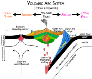
Forearc is a plate tectonic term referring to a region between an oceanic trench, also known as a subduction zone, and the associated volcanic arc. Forearc regions are present along a convergent margins and eponymously form 'in front of' the volcanic arcs that are characteristic of convergent plate margins. A back-arc region is the companion region behind the volcanic arc.

The neritic zone is the relatively shallow part of the ocean above the drop-off of the continental shelf, approximately 200 meters (660 ft) in depth. From the point of view of marine biology it forms a relatively stable and well-illuminated environment for marine life, from plankton up to large fish and corals, while physical oceanography sees it as where the oceanic system interacts with the coast.

Lincoln Sea is a body of water in the Arctic Ocean, stretching from Cape Columbia, Canada, in the west to Cape Morris Jesup, Greenland, in the east. The northern limit is defined as the great circle line between those two headlands. It is covered with sea ice throughout the year, the thickest sea ice in the Arctic Ocean, which can be up to 15 m (49 ft) thick. Water depths range from 100 m (330 ft) to 300 m (980 ft). Water and ice from Lincoln Sea empty into Robeson Channel, the northernmost part of Nares Strait, most of the time.

Pelagic fish live in the pelagic zone of ocean or lake waters—being neither close to the bottom nor near the shore—in contrast with demersal fish that do live on or near the bottom, and reef fish that are associated with coral reefs.

The North Pacific Gyre (NPG) or North Pacific Subtropical Gyre (NPSG), located in the northern Pacific Ocean, is one of the five major oceanic gyres. This gyre covers most of the northern Pacific Ocean. It is the largest ecosystem on Earth, located between the equator and 50° N latitude, and comprising 20 million square kilometers. The gyre has a clockwise circular pattern and is formed by four prevailing ocean currents: the North Pacific Current to the north, the California Current to the east, the North Equatorial Current to the south, and the Kuroshio Current to the west. It is the site of an unusually intense collection of human-created marine debris, known as the Great Pacific Garbage Patch.

A passive margin is the transition between oceanic and continental lithosphere that is not an active plate margin. A passive margin forms by sedimentation above an ancient rift, now marked by transitional lithosphere. Continental rifting creates new ocean basins. Eventually the continental rift forms a mid-ocean ridge and the locus of extension moves away from the continent-ocean boundary. The transition between the continental and oceanic lithosphere that was originally created by rifting is known as a passive margin.

Ekman transport is part of Ekman motion theory, first investigated in 1902 by Vagn Walfrid Ekman. Winds are the main source of energy for ocean circulation, and Ekman Transport is a component of wind-driven ocean current. Ekman transport occurs when ocean surface waters are influenced by the friction force acting on them via the wind. As the wind blows it casts a friction force on the ocean surface that drags the upper 10-100m of the water column with it. However, due to the influence of the Coriolis effect, the ocean water moves at a 90° angle from the direction of the surface wind. The direction of transport is dependent on the hemisphere: in the northern hemisphere, transport occurs at 90° clockwise from wind direction, while in the southern hemisphere it occurs at 90° anticlockwise. This phenomenon was first noted by Fridtjof Nansen, who recorded that ice transport appeared to occur at an angle to the wind direction during his Arctic expedition during the 1890s. Ekman transport has significant impacts on the biogeochemical properties of the world's oceans. This is because it leads to upwelling and downwelling in order to obey mass conservation laws. Mass conservation, in reference to Ekman transfer, requires that any water displaced within an area must be replenished. This can be done by either Ekman suction or Ekman pumping depending on wind patterns.

In physical oceanography, Langmuir circulation consists of a series of shallow, slow, counter-rotating vortices at the ocean's surface aligned with the wind. These circulations are developed when wind blows steadily over the sea surface. Irving Langmuir discovered this phenomenon after observing windrows of seaweed in the Sargasso Sea in 1927. Langmuir circulations circulate within the mixed layer; however, it is not yet so clear how strongly they can cause mixing at the base of the mixed layer.
The following outline is provided as an overview of and introduction to Oceanography.
Boundary currents are ocean currents with dynamics determined by the presence of a coastline, and fall into two distinct categories: western boundary currents and eastern boundary currents.

A lead is a large fracture within an expanse of sea ice, defining a linear area of open water that can be used for navigation purposes. Leads vary in width from meters to hundreds of meters. As is the case for polynyas, leads allow the direct interaction between the atmosphere and the ocean, and are important for Arctic sea ice ecology. Additionally it has been lately found that ice leads contribute significantly to the amount of mercury deposited onto surface and leaked into the ocean. If the air is cold enough, the water within a lead quickly refreezes, such that in many cases, leads are partly or entirely covered by a thin layer of new ice.
The ocean is the body of salt water that covers approximately 70.8% of the surface of Earth and contains 97% of Earth's water. An ocean can also refer to any of the large bodies of water into which the world ocean is conventionally divided. Separate names are used to identify five different areas of the ocean: Pacific, Atlantic, Indian, Southern (Antarctic), and Arctic. Seawater covers approximately 361,000,000 km2 (139,000,000 sq mi) of the planet. The ocean is the principal component of Earth's hydrosphere, and therefore integral to life on Earth. Acting as a huge heat reservoir, the ocean influences climate and weather patterns, the carbon cycle, and the water cycle.
This is a glossary of terms used in fisheries, fisheries management and fisheries science.
A Wind generated current is a flow in a body of water that is generated by wind friction on its surface. Wind can generate surface currents on water bodies of any size. The depth and strength of the current depend on the wind strength and duration, and on friction and viscosity losses, but are limited to about 400 m depth by the mechanism, and to lesser depths where the water is shallower. The direction of flow is influenced by the Coriolis effect, and is offset to the right of the wind direction in the Northern Hemisphere, and to the left in the Southern Hemisphere. A wind current can induce secondary water flow in the form of upwelling and downwelling, geostrophic flow, and western boundary currents.
References
- Thomson, R.E. 1981. Oceanography of the British Columbia Coast. Department of Fisheries and Oceans. Canadian Special Publication of Fisheries and Aquatic Sciences 56. Ottawa. 291.

