
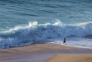
A rip current is a specific type of water current that can occur near beaches where waves break. A rip is a strong, localized, and narrow current of water that moves directly away from the shore by cutting through the lines of breaking waves, like a river flowing out to sea. The force of the current in a rip is strongest and fastest next to the surface of the water.

An amphidromic point, also called a tidal node, is a geographical location which has zero tidal amplitude for one harmonic constituent of the tide. The tidal range for that harmonic constituent increases with distance from this point, though not uniformly. As such, the concept of amphidromic points is crucial to understanding tidal behaviour. The term derives from the Greek words amphi ("around") and dromos ("running"), referring to the rotary tides which circulate around amphidromic points.
In fluid dynamics, a wind wave, or wind-generated water wave, is a surface wave that occurs on the free surface of bodies of water as a result of the wind blowing over the water's surface. The contact distance in the direction of the wind is known as the fetch. Waves in the oceans can travel thousands of kilometers before reaching land. Wind waves on Earth range in size from small ripples to waves over 30 m (100 ft) high, being limited by wind speed, duration, fetch, and water depth.

Sea spray are aerosol particles formed from the ocean, mostly by ejection into Earth's atmosphere by bursting bubbles at the air-sea interface. Sea spray contains both organic matter and inorganic salts that form sea salt aerosol (SSA). SSA has the ability to form cloud condensation nuclei (CCN) and remove anthropogenic aerosol pollutants from the atmosphere. Coarse sea spray has also been found to inhibit the development of lightning in storm clouds.

Volcanic lightning is an electrical discharge caused by a volcanic eruption rather than from an ordinary thunderstorm. Volcanic lightning arises from colliding, fragmenting particles of volcanic ash, which generate static electricity within the volcanic plume, leading to the name dirty thunderstorm. Moist convection and ice formation also drive the eruption plume dynamics and can trigger volcanic lightning. Unlike ordinary thunderstorms, volcanic lightning can also occur before any ice crystals have formed in the ash cloud.
A mouth bar is an element of a deltaic system, which refers to the typically mid-channel deposition of the sediment transported by the river channel at the river mouth.
In physical oceanography, undertow is the undercurrent that moves offshore while waves approach the shore. Undertow is a natural and universal feature for almost any large body of water; it is a return flow compensating for the onshore-directed average transport of water by the waves in the zone above the wave troughs. The undertow's flow velocities are generally strongest in the surf zone, where the water is shallow and the waves are high due to shoaling.

Infragravity waves are surface gravity waves with frequencies lower than the wind waves – consisting of both wind sea and swell – thus corresponding with the part of the wave spectrum lower than the frequencies directly generated by forcing through the wind.
Sea ice is a complex composite composed primarily of pure ice in various states of crystallization, but including air bubbles and pockets of brine. Understanding its growth processes is important for climate modellers and remote sensing specialists, since the composition and microstructural properties of the ice affect how it reflects or absorbs sunlight.

In fluid dynamics, the radiation stress is the depth-integrated – and thereafter phase-averaged – excess momentum flux caused by the presence of the surface gravity waves, which is exerted on the mean flow. The radiation stresses behave as a second-order tensor.

Regional Ocean Modeling System (ROMS) is a free-surface, terrain-following, primitive equations ocean model widely used by the scientific community for a diverse range of applications. The model is developed and supported by researchers at the Rutgers University, University of California Los Angeles and contributors worldwide.
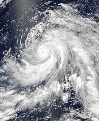
Cyclonic Niño is a climatological phenomenon that has been observed in climate models where tropical cyclone activity is increased. Increased tropical cyclone activity mixes ocean waters, introducing cooling in the upper layer of the ocean that quickly dissipates and warming in deeper layers that lasts considerably more, resulting in a net warming of the ocean.
Richard Mansergh Thorne was an American physicist and a distinguished professor in the department of atmospheric and oceanic sciences at UCLA. He was known for his contributions to space plasma physics. He was a fellow of the American Geophysical Union.
Tides in marginal seas are tides affected by their location in semi-enclosed areas along the margins of continents and differ from tides in the open oceans. Tides are water level variations caused by the gravitational interaction between the moon, the sun and the earth. The resulting tidal force is a secondary effect of gravity: it is the difference between the actual gravitational force and the centrifugal force. While the centrifugal force is constant across the earth, the gravitational force is dependent on the distance between the two bodies and is therefore not constant across the earth. The tidal force is thus the difference between these two forces on each location on the earth.
The nonlinearity of surface gravity waves refers to their deviations from a sinusoidal shape. In the fields of physical oceanography and coastal engineering, the two categories of nonlinearity are skewness and asymmetry. Wave skewness and asymmetry occur when waves encounter an opposing current or a shallow area. As waves shoal in the nearshore zone, in addition to their wavelength and height changing, their asymmetry and skewness also change. Wave skewness and asymmetry are often implicated in ocean engineering and coastal engineering for the modelling of random sea states, in particular regarding the distribution of wave height, wavelength and crest length. For practical engineering purposes, it is important to know the probability of these wave characteristics in seas and oceans at a given place and time. This knowledge is crucial for the prediction of extreme waves, which are a danger for ships and offshore structures. Satellite altimeter Envisat RA-2 data shows geographically coherent skewness fields in the ocean and from the data has been concluded that large values of skewness occur primarily in regions of large significant wave height.
Rebecca Woodgate is a professor at the University of Washington known for her work on ocean circulation in polar regions.

Internal wave breaking is a process during which internal gravity waves attain a large amplitude compared to their length scale, become nonlinearly unstable and finally break. This process is accompanied by turbulent dissipation and mixing. As internal gravity waves carry energy and momentum from the environment of their inception, breaking and subsequent turbulent mixing affects the fluid characteristics in locations of breaking. Consequently, internal wave breaking influences even the large scale flows and composition in both the ocean and the atmosphere. In the atmosphere, momentum deposition by internal wave breaking plays a key role in atmospheric phenomena such as the Quasi-Biennial Oscillation and the Brewer-Dobson Circulation. In the deep ocean, mixing induced by internal wave breaking is an important driver of the meridional overturning circulation. On smaller scales, breaking-induced mixing is important for sediment transport and for nutrient supply to the photic zone. Most breaking of oceanic internal waves occurs in continental shelves, well below the ocean surface, which makes it a difficult phenomenon to observe.
The sea surface skin temperature (SSTskin), or ocean skin temperature, is the temperature of the sea surface as determined through its infrared spectrum (3.7–12 μm) and represents the temperature of the sublayer of water at a depth of 10–20 μm. High-resolution data of skin temperature gained by satellites in passive infrared measurements is a crucial constituent in determining the sea surface temperature (SST).

The North Brazil Current (NBC) retroflects north-eastwards and merges into the North Equatorial Counter Current (NECC). The retroflection occurs in a seasonal pattern when there is strong retroflection from late summer to early winter. There is weakened or no retroflection during other times of the year. Just like in the Agulhas Current, the retroflection also sheds some eddies that make their way to the Caribbean Sea through the Lesser Antilles.

Wind setup, also known as wind effect or storm effect, refers to the rise in water level in seas or lakes caused by winds pushing the water in a specific direction. As the wind moves across the water's surface, it applies a shear stress to the water, prompting the formation of a wind-driven current. When this current encounters a shoreline, the water level along the shore increases, generating a hydrostatic counterforce in equilibrium with the shear force.


