Sea-level curve

Last updated
Comparison of two sea level reconstructions during the last 500 Myr: Exxon curve and Hallam curve. The scale of change during the last glacial/interglacial transition is indicated with a black bar. Phanerozoic Sea Level.png
Comparison of two sea level reconstructions during the last 500 Myr: Exxon curve and Hallam curve. The scale of change during the last glacial/interglacial transition is indicated with a black bar.

The sea-level curve (also known as the eustatic curve) is the representation of the changes of the sea level relative to present day mean sea level as gleaned from the stratigraphic record throughout the geological history.

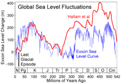
The first such curve is the Vail curve or Exxon curve. The names of the curve refer to the fact that in 1977 a team of Exxon geologists from Esso Production Research headed by Peter Vail published a monograph [1] on seismic stratigraphic principles and global (eustati)) sea-level changes. Their sea-level curve was based on seismic and biostratigraphic data accumulated during petroleum exploration. [2]

The Vail curve (and the monograph itself) was the subject of debate among geologists, because it was based on undisclosed commercially confidential stratigraphic data, and hence not independently verifiable. [3] Because of this, there were later efforts to establish a sea-level curve based on non-commercial, public domain data from outcrops exposed on land and thus verifiable by other reserchers.

In 1987–1988 a revised eustatic sea-level curve for the Mesozoic and Cenozoic eras was published in Science magazine, now known as the Haq et al sea-level curve, [4] in reference to the marine geologist/oceanographer Bilal Haq [2]

Bilal Haq and Stephen Schutter later published the Paleozoic sea-level curve in 2008 also in Science. Subsequent revisions of the Mesozoic eustatic sea-level curve have been published by Haq for the Cretaceous, Jurassic, and Triassic, respectively in 2014, 2017, and 2018. Haq and his co-workers have now completed the sea-level history of the entire Phanerozoic Eon.

Related Research Articles

Geology is a branch of natural science concerned with Earth and other astronomical objects, the rocks of which it is composed, and the processes by which they change over time. Modern geology significantly overlaps all other Earth sciences, including hydrology. It is integrated with Earth system science and planetary science.

The Jurassic is a geologic period and stratigraphic system that spanned from the end of the Triassic Period 201.4 million years ago (Mya) to the beginning of the Cretaceous Period, approximately 145 Mya. The Jurassic constitutes the middle period of the Mesozoic Era and is named after the Jura Mountains, where limestone strata from the period were first identified.

The Triassic is a geologic period and system which spans 50.6 million years from the end of the Permian Period 251.902 million years ago (Mya), to the beginning of the Jurassic Period 201.36 Mya. The Triassic is the first and shortest period of the Mesozoic Era. Both the start and end of the period are marked by major extinction events. The Triassic Period is subdivided into three epochs: Early Triassic, Middle Triassic and Late Triassic.

<span class="mw-page-title-main">Sedimentary basin</span> Regions of long-term subsidence creating space for infilling by sediments

Sedimentary basins are region-scale depressions of the Earth's crust where subsidence has occurred and a thick sequence of sediments have accumulated to form a large three-dimensional body of sedimentary rock. They form when long-term subsidence creates a regional depression that provides accommodation space for accumulation of sediments. Over millions or tens or hundreds of millions of years the deposition of sediment, primarily gravity-driven transportation of water-borne eroded material, acts to fill the depression. As the sediments are buried, they are subject to increasing pressure and begin the processes of compaction and lithification that transform them into sedimentary rock.

<span class="mw-page-title-main">Raised beach</span> Emergent coastal landform

A raised beach, coastal terrace, or perched coastline is a relatively flat, horizontal or gently inclined surface of marine origin, mostly an old abrasion platform which has been lifted out of the sphere of wave activity. Thus, it lies above or under the current sea level, depending on the time of its formation. It is bounded by a steeper ascending slope on the landward side and a steeper descending slope on the seaward side. Due to its generally flat shape, it is often used for anthropogenic structures such as settlements and infrastructure.

The eustatic sea level is the distance from the center of the Earth to the sea surface. An increase of the eustatic sea level can be generated by decreasing glaciation, increasing spreading rates of the mid-ocean ridges or increasing the number of mid-oceanic ridges. Conversely, increasing glaciation, decreasing spreading rates or fewer mid-ocean ridges can lead to a fall in the eustatic sea level.

Sequence stratigraphy is a branch of geology, specifically a branch of stratigraphy, that attempts to discern and understand historic geology through time by subdividing and linking sedimentary deposits into unconformity bounded units on a variety of scales. The essence of the method is mapping of strata based on identification of surfaces which are assumed to represent time lines, thereby placing stratigraphy in chronostratigraphic framework allowing understanding of the evolution of the earth's surface in a particular region through time. Sequence stratigraphy is a useful alternative to a purely lithostratigraphic approach, which emphasizes solely based on the compositional similarity of the lithology of rock units rather than time significance. Unconformities are particularly important in understanding geologic history because they represent erosional surfaces where there is a clear gap in the record. Conversely within a sequence the geologic record should be relatively continuous and complete record that is genetically related.

<span class="mw-page-title-main">Cratonic sequence</span> Very large-scale lithostratographic sequence

A cratonic sequence in geology is a very large-scale lithostratigraphic sequence in the rock record that represents a complete cycle of marine transgression and regression on a craton over geologic time. They are geologic evidence of relative sea level rising and then falling, thereby depositing varying layers of sediment onto the craton, now expressed as sedimentary rock. Places such as the Grand Canyon are a good visual example of this process, demonstrating the changes between layers deposited over time as the ancient environment changed.

The Absaroka sequence was a cratonic sequence that extended from the end of the Mississippian through the Permian periods. It is the unconformity between this sequence and the preceding Kaskaskia that divides the Carboniferous into the Mississippian and Pennsylvanian periods in North America.

<span class="mw-page-title-main">Cyclothems</span> Alternating sequences of marine and non-marine sediments

In geology, cyclothems are alternating stratigraphic sequences of marine and non-marine sediments, sometimes interbedded with coal seams. Historically, the term was defined by the European coal geologists who worked in coal basins formed during the Carboniferous and earliest Permian periods. The cyclothems consist of repeated sequences, each typically several meters thick, of sandstone resting upon an erosional surface, passing upwards to pelites and topped by coal.

Stratigraphic cycles refer to the transgressive and regressive sequences bounded by unconformities in the stratigraphic record on the cratons. These cycles represent a large scale eustasy cycle since the Cambrian period with further sub-divisions of those units.

<span class="mw-page-title-main">Geological history of Earth</span> The sequence of major geological events in Earths past

The geological history of Earth follows the major geological events in Earth's past based on the geological time scale, a system of chronological measurement based on the study of the planet's rock layers (stratigraphy). Earth formed about 4.54 billion years ago by accretion from the solar nebula, a disk-shaped mass of dust and gas left over from the formation of the Sun, which also created the rest of the Solar System.

Peter R. Vail is an American geologist and geophysicist, the namesake of the Vail curve of sea level changes. Vail earned his AB at Dartmouth College in 1952, followed by M.S. and Ph.D. degrees from Northwestern University in 1956. He is currently the W. Maurice Ewing Professor, Emeritus, in the Department of Earth Science at Rice University.

<span class="mw-page-title-main">Growth fault</span>

Growth faults are syndepositional or syn-sedimentary extensional faults that initiate and evolve at the margins of continental plates. They extend parallel to passive margins that have high sediment supply. Their fault plane dips mostly toward the basin and has long-term continuous displacement. Figure one shows a growth fault with a concave upward fault plane that has high updip angle and flattened at its base into zone of detachment or décollement. This angle is continuously changing from nearly vertical in the updip area to nearly horizontal in the downdip area.

<span class="mw-page-title-main">Past sea level</span> Sea level variations over geological time scales

Global or eustatic sea level has fluctuated significantly over Earth's history. The main factors affecting sea level are the amount and volume of available water and the shape and volume of the ocean basins. The primary influences on water volume are the temperature of the seawater, which affects density, and the amounts of water retained in other reservoirs like rivers, aquifers, lakes, glaciers, polar ice caps and sea ice. Over geological timescales, changes in the shape of the oceanic basins and in land/sea distribution affect sea level. In addition to eustatic changes, local changes in sea level are caused by tectonic uplift and subsidence.

One of the major depositional strata in the Himalaya is the Lesser Himalayan Strata from the Paleozoic to Mesozoic eras. It had a quite different marine succession during the Paleozoic, as most parts of it are sparsely fossiliferous or even devoid of any well-defined fossils. Moreover, it consists of many varied lithofacies, making correlation work more difficult. This article describes the major formations of the Paleozoic – Mesozoic Lesser Himalayan Strata, including the Tal Formation, Gondwana Strata, Singtali Formation and Subathu Formation.

<span class="mw-page-title-main">Bilal U. Haq</span> Pakistani-American geoscientist and poet

Bilal U. Haq is a Pakistani-American geoscientist who is currently affiliated with and divides his time between the Smithsonian Institution in Washington, DC, and Sorbonne University's Institute of Earth Sciences in Paris, France. He is best known for his work on the Phanerozoic sea-level fluctuations and eustatic curves that are widely used in the academia and industry as the basis for global stratigraphy and in exploration geology. He is a laureate of the Prestwich Prize for geosciences from France.

Seismic stratigraphy is a method for studying sedimentary rock in the deep subsurface based on seismic data acquisition.

Incised valleys are mountain-valley-like features that commonly result from river down cutting into coastal plains and continental shelves in response to marine regression. They are the key evidence to identify sequence boundary on seismic profiles and outcrops. The magnitudes of their down cutting have been used to estimate the global sea-level variations.

<i>Palynodinium</i> Extinct genus of dinoflagellate cysts

Palynodinium is an extinct genus of organic-walled dinoflagellate cyst. It is a fossil species of dinoflagellate cyst used to demarcate the K/Pg boundary, which marks the terminal Cretaceous and the extinction of the dinosaurs. Palynodinium grallator was among the microfossils which lead to the recent discovery of the K/Pg event record in marine sediments of the northeast Pacific.

References

  1. PR Vail, RM Mitchum Jr, S Thompson III, 1977, Seismic Stratigraphy and Global Changes of Sea Level: Part 4. Global Cycles of Relative Changes of Sea Level.: Section 2. Application of Seismic Reflection Configuration to Stratigraphic Interpretation, AAPG Special Volumes 165, 83-97
  2. 1 2 Principles of Paleoclimatology, by Thomas M. Cronin (1999) ISBN   0-231-10955-5, pp. 381, 382
  3. "Climate Change", William James Burroughs p 87
  4. BU Haq, JAN Hardenbol, PR Vail, 1987, Chronology of fluctuating sea levels since the Triassic, Science 235 (4793), 1156-1167

See also