A mid-ocean ridge (MOR) is a seafloor mountain system formed by plate tectonics. It typically has a depth of about 2,600 meters (8,500 ft) and rises about 2,000 meters (6,600 ft) above the deepest portion of an ocean basin. This feature is where seafloor spreading takes place along a divergent plate boundary. The rate of seafloor spreading determines the morphology of the crest of the mid-ocean ridge and its width in an ocean basin.
The production of new seafloor and oceanic lithosphere results from mantle upwelling in response to plate separation. The melt rises as magma at the linear weakness between the separating plates, and emerges as lava, creating new oceanic crust and lithosphere upon cooling.
The first discovered mid-ocean ridge was the Mid-Atlantic Ridge, which is a spreading center that bisects the North and South Atlantic basins; hence the origin of the name 'mid-ocean ridge'. Most oceanic spreading centers are not in the middle of their hosting ocean basis but regardless, are traditionally called mid-ocean ridges. Mid-ocean ridges around the globe are linked by plate tectonic boundaries and the trace of the ridges across the ocean floor appears similar to the seam of a baseball. The mid-ocean ridge system thus is the longest mountain range on Earth, reaching about 65,000 km (40,000 mi).
Most mid-ocean ridges of the world are connected and form the Ocean Ridge, a global mid-oceanic ridge system that is part of every ocean, making it the longest mountain range in the world. The continuous mountain range is 65,000 km (40,400 mi) long (several times longer than the Andes, the longest continental mountain range), and the total length of the oceanic ridge system is 80,000 km (49,700 mi) long. [1]
At the spreading center on a mid-ocean ridge, the depth of the seafloor is approximately 2,600 meters (8,500 ft). [2] [3] On the ridge flanks, the depth of the seafloor (or the height of a location on a mid-ocean ridge above a base-level) is correlated with its age (age of the lithosphere where depth is measured). The depth-age relation can be modeled by the cooling of a lithosphere plate [4] [5] or mantle half-space. [6] A good approximation is that the depth of the seafloor at a location on a spreading mid-ocean ridge is proportional to the square root of the age of the seafloor. [6] The overall shape of ridges results from Pratt isostasy: close to the ridge axis, there is a hot, low-density mantle supporting the oceanic crust. As the oceanic plate cools, away from the ridge axis, the oceanic mantle lithosphere (the colder, denser part of the mantle that, together with the crust, comprises the oceanic plates) thickens, and the density increases. Thus older seafloor is underlain by denser material and is deeper. [4] [5]
Spreading rate is the rate at which an ocean basin widens due to seafloor spreading. Rates can be computed by mapping marine magnetic anomalies that span mid-ocean ridges. As crystallized basalt extruded at a ridge axis cools below Curie points of appropriate iron-titanium oxides, magnetic field directions parallel to the Earth's magnetic field are recorded in those oxides. The orientations of the field preserved in the oceanic crust comprise a record of directions of the Earth's magnetic field with time. Because the field has reversed directions at known intervals throughout its history, the pattern of geomagnetic reversals in the ocean crust can be used as an indicator of age; given the crustal age and distance from the ridge axis, spreading rates can be calculated. [2] [3] [7] [8]
Spreading rates range from approximately 10–200 mm/yr. [2] [3] Slow-spreading ridges such as the Mid-Atlantic Ridge have spread much less far (showing a steeper profile) than faster ridges such as the East Pacific Rise (gentle profile) for the same amount of time and cooling and consequent bathymetric deepening. [2] Slow-spreading ridges (less than 40 mm/yr) generally have large rift valleys, sometimes as wide as 10–20 km (6.2–12.4 mi), and very rugged terrain at the ridge crest that can have relief of up to 1,000 m (3,300 ft). [2] [3] [9] [10] By contrast, fast-spreading ridges (greater than 90 mm/yr) such as the East Pacific Rise lack rift valleys. The spreading rate of the North Atlantic Ocean is ~ 25 mm/yr, while in the Pacific region, it is 80–145 mm/yr. [11] The highest known rate is over 200 mm/yr in the Miocene on the East Pacific Rise. [12] Ridges that spread at rates <20 mm/yr are referred to as ultraslow spreading ridges [3] [13] (e.g., the Gakkel Ridge in the Arctic Ocean and the Southwest Indian Ridge).
The spreading center or axis commonly connects to a transform fault oriented at right angles to the axis. The flanks of mid-ocean ridges are in many places marked by the inactive scars of transform faults called fracture zones. At faster spreading rates the axes often display overlapping spreading centers that lack connecting transform faults. [2] [14] The depth of the axis changes in a systematic way with shallower depths between offsets such as transform faults and overlapping spreading centers dividing the axis into segments. One hypothesis for different along-axis depths is variations in magma supply to the spreading center. [2] Ultra-slow spreading ridges form both magmatic and amagmatic (currently lack volcanic activity) ridge segments without transform faults. [13]
Mid-ocean ridges exhibit active volcanism and seismicity. [3] The oceanic crust is in a constant state of 'renewal' at the mid-ocean ridges by the processes of seafloor spreading and plate tectonics. New magma steadily emerges onto the ocean floor and intrudes into the existing ocean crust at and near rifts along the ridge axes. The rocks making up the crust below the seafloor are youngest along the axis of the ridge and age with increasing distance from that axis. New magma of basalt composition emerges at and near the axis because of decompression melting in the underlying Earth's mantle. [15] The isentropic upwelling solid mantle material exceeds the solidus temperature and melts.
The crystallized magma forms a new crust of basalt known as MORB for mid-ocean ridge basalt, and gabbro below it in the lower oceanic crust. [16] Mid-ocean ridge basalt is a tholeiitic basalt and is low in incompatible elements. [17] [18] Hydrothermal vents fueled by magmatic and volcanic heat are a common feature at oceanic spreading centers. [19] [20] A feature of the elevated ridges is their relatively high heat flow values, of about 1–10 μcal/cm2s, [21] or roughly 0.04–0.4 W/m2.
Most crust in the ocean basins is less than 200 million years old, [22] [23] which is much younger than the 4.54 billion year age of Earth. This fact reflects the process of lithosphere recycling into the Earth's mantle during subduction. As the oceanic crust and lithosphere moves away from the ridge axis, the peridotite in the underlying mantle lithosphere cools and becomes more rigid. The crust and the relatively rigid peridotite below it make up the oceanic lithosphere, which sits above the less rigid and viscous asthenosphere. [3]
The oceanic lithosphere is formed at an oceanic ridge, while the lithosphere is subducted back into the asthenosphere at ocean trenches. Two processes, ridge-push and slab pull, are thought to be responsible for spreading at mid-ocean ridges. [24] Ridge push refers to the gravitational sliding of the ocean plate that is raised above the hotter asthenosphere, thus creating a body force causing sliding of the plate downslope. [25] In slab pull the weight of a tectonic plate being subducted (pulled) below an overlying plate at a subduction zone drags the rest of the plate along behind it. The slab pull mechanism is considered to be contributing more than the ridge push. [24] [26]
A process previously proposed to contribute to plate motion and the formation of new oceanic crust at mid-ocean ridges is the "mantle conveyor" due to deep convection (see image). [27] [28] However, some studies have shown that the upper mantle (asthenosphere) is too plastic (flexible) to generate enough friction to pull the tectonic plate along. [29] [30] Moreover, mantle upwelling that causes magma to form beneath the ocean ridges appears to involve only its upper 400 km (250 mi), as deduced from seismic tomography and observations of the seismic discontinuity in the upper mantle at about 400 km (250 mi). On the other hand, some of the world's largest tectonic plates such as the North American plate and South American plate are in motion, yet only are being subducted in restricted locations such as the Lesser Antilles Arc and Scotia Arc, pointing to action by the ridge push body force on these plates. Computer modeling of the plates and mantle motions suggest that plate motion and mantle convection are not connected, and the main plate driving force is slab pull. [31]
Increased rates of seafloor spreading (i.e. the rate of expansion of the mid-ocean ridge) have caused the global (eustatic) sea level to rise over very long timescales (millions of years). [32] [33] Increased seafloor spreading means that the mid-ocean ridge will then expand and form a broader ridge with decreased average depth, taking up more space in the ocean basin. This displaces the overlying ocean and causes sea levels to rise. [34]
Sealevel change can be attributed to other factors (thermal expansion, ice melting, and mantle convection creating dynamic topography [35] ). Over very long timescales, however, it is the result of changes in the volume of the ocean basins which are, in turn, affected by rates of seafloor spreading along the mid-ocean ridges. [36]
The 100 to 170 meters higher sea level of the Cretaceous Period (144–65 Ma) is partly attributed to plate tectonics because thermal expansion and the absence of ice sheets only account for some of the extra sea level. [34]
Seafloor spreading on mid-ocean ridges is a global scale ion-exchange system. [37] Hydrothermal vents at spreading centers introduce various amounts of iron, sulfur, manganese, silicon, and other elements into the ocean, some of which are recycled into the ocean crust. Helium-3, an isotope that accompanies volcanism from the mantle, is emitted by hydrothermal vents and can be detected in plumes within the ocean. [38]
Fast spreading rates will expand the mid-ocean ridge causing basalt reactions with seawater to happen more rapidly. The magnesium/calcium ratio will be lower because more magnesium ions are being removed from seawater and consumed by the rock, and more calcium ions are being removed from the rock and released into seawater. Hydrothermal activity at the ridge crest is efficient in removing magnesium. [39] A lower Mg/Ca ratio favors the precipitation of low-Mg calcite polymorphs of calcium carbonate (calcite seas). [40] [41]
Slow spreading at mid-ocean ridges has the opposite effect and will result in a higher Mg/Ca ratio favoring the precipitation of aragonite and high-Mg calcite polymorphs of calcium carbonate (aragonite seas). [41]
Experiments show that most modern high-Mg calcite organisms would have been low-Mg calcite in past calcite seas, [42] meaning that the Mg/Ca ratio in an organism's skeleton varies with the Mg/Ca ratio of the seawater in which it was grown.
The mineralogy of reef-building and sediment-producing organisms is thus regulated by chemical reactions occurring along the mid-ocean ridge, the rate of which is controlled by the rate of sea-floor spreading. [39] [42]
The first indications that a ridge bisects the Atlantic Ocean basin came from the results of the British Challenger expedition in the nineteenth century. [43] Soundings from lines dropped to the seafloor were analyzed by oceanographers Matthew Fontaine Maury and Charles Wyville Thomson and revealed a prominent rise in the seafloor that ran down the Atlantic basin from north to south. Sonar echo sounders confirmed this in the early twentieth century. [44]
It was not until after World War II, when the ocean floor was surveyed in more detail, that the full extent of mid-ocean ridges became known. The Vema , a ship of the Lamont–Doherty Earth Observatory of Columbia University, traversed the Atlantic Ocean, recording echo sounder data on the depth of the ocean floor. A team led by Marie Tharp and Bruce Heezen concluded that there was an enormous mountain chain with a rift valley at its crest, running up the middle of the Atlantic Ocean. Scientists named it the 'Mid-Atlantic Ridge'. Other research showed that the ridge crest was seismically active [45] and fresh lavas were found in the rift valley. [46] Also, crustal heat flow was higher here than elsewhere in the Atlantic Ocean basin. [47]
At first, the ridge was thought to be a feature specific to the Atlantic Ocean. However, as surveys of the ocean floor continued around the world, it was discovered that every ocean contains parts of the mid-ocean ridge system. The German Meteor expedition traced the mid-ocean ridge from the South Atlantic into the Indian Ocean early in the twentieth century. Although the first-discovered section of the ridge system runs down the middle of the Atlantic Ocean, it was found that most mid-ocean ridges are located away from the center of other ocean basins. [2] [3]
Alfred Wegener proposed the theory of continental drift in 1912. He stated: "the Mid-Atlantic Ridge ... zone in which the floor of the Atlantic, as it keeps spreading, is continuously tearing open and making space for fresh, relatively fluid and hot sima [rising] from depth". [48] However, Wegener did not pursue this observation in his later works and his theory was dismissed by geologists because there was no mechanism to explain how continents could plow through ocean crust, and the theory became largely forgotten.
Following the discovery of the worldwide extent of the mid-ocean ridge in the 1950s, geologists faced a new task: explaining how such an enormous geological structure could have formed. In the 1960s, geologists discovered and began to propose mechanisms for seafloor spreading. The discovery of mid-ocean ridges and the process of seafloor spreading allowed for Wegener's theory to be expanded so that it included the movement of oceanic crust as well as the continents. [49] Plate tectonics was a suitable explanation for seafloor spreading, and the acceptance of plate tectonics by the majority of geologists resulted in a major paradigm shift in geological thinking.
It is estimated that along Earth's mid-ocean ridges every year 2.7 km2 (1.0 sq mi) of new seafloor is formed by this process. [50] With a crustal thickness of 7 km (4.3 mi), this amounts to about 19 km3 (4.6 cu mi) of new ocean crust formed every year. [50]
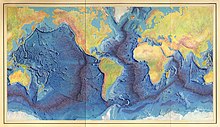
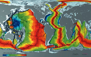
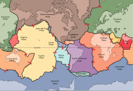
Plate tectonics is the scientific theory that Earth's lithosphere comprises a number of large tectonic plates, which have been slowly moving since 3–4 billion years ago. The model builds on the concept of continental drift, an idea developed during the first decades of the 20th century. Plate tectonics came to be accepted by geoscientists after seafloor spreading was validated in the mid-to-late 1960s. The processes that result in plates and shape Earth's crust are called tectonics. Tectonic plates also occur in other planets and moons.
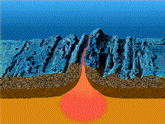
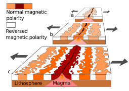
Seafloor spreading, or seafloor spread, is a process that occurs at mid-ocean ridges, where new oceanic crust is formed through volcanic activity and then gradually moves away from the ridge.
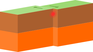
A transform fault or transform boundary, is a fault along a plate boundary where the motion is predominantly horizontal. It ends abruptly where it connects to another plate boundary, either another transform, a spreading ridge, or a subduction zone. A transform fault is a special case of a strike-slip fault that also forms a plate boundary.
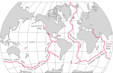
In plate tectonics, a divergent boundary or divergent plate boundary is a linear feature that exists between two tectonic plates that are moving away from each other. Divergent boundaries within continents initially produce rifts, which eventually become rift valleys. Most active divergent plate boundaries occur between oceanic plates and exist as mid-oceanic ridges.
A convergent boundary is an area on Earth where two or more lithospheric plates collide. One plate eventually slides beneath the other, a process known as subduction. The subduction zone can be defined by a plane where many earthquakes occur, called the Wadati–Benioff zone. These collisions happen on scales of millions to tens of millions of years and can lead to volcanism, earthquakes, orogenesis, destruction of lithosphere, and deformation. Convergent boundaries occur between oceanic-oceanic lithosphere, oceanic-continental lithosphere, and continental-continental lithosphere. The geologic features related to convergent boundaries vary depending on crust types.
Oceanic crust is the uppermost layer of the oceanic portion of the tectonic plates. It is composed of the upper oceanic crust, with pillow lavas and a dike complex, and the lower oceanic crust, composed of troctolite, gabbro and ultramafic cumulates. The crust overlies the rigid uppermost layer of the mantle. The crust and the rigid upper mantle layer together constitute oceanic lithosphere.
The East Pacific Rise (EPR) is a mid-ocean rise, at a divergent tectonic plate boundary, located along the floor of the Pacific Ocean. It separates the Pacific plate to the west from the North American plate, the Rivera plate, the Cocos plate, the Nazca plate, and the Antarctic plate. It runs south from the Gulf of California in the Salton Sea basin in Southern California to a point near 55°S130°W, where it joins the Pacific-Antarctic Ridge (PAR) trending west-south-west towards Antarctica, near New Zealand. Much of the rise lies about 3,200 km (2,000 mi) off the South American coast and reaches a height about 1,800–2,700 m (5,900–8,900 ft) above the surrounding seafloor.
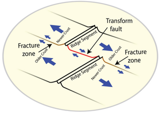
A fracture zone is a linear feature on the ocean floor—often hundreds, even thousands of kilometers long—resulting from the action of offset mid-ocean ridge axis segments. They are a consequence of plate tectonics. Lithospheric plates on either side of an active transform fault move in opposite directions; here, strike-slip activity occurs. Fracture zones extend past the transform faults, away from the ridge axis; are usually seismically inactive, although they can display evidence of transform fault activity, primarily in the different ages of the crust on opposite sides of the zone.
Marine geology or geological oceanography is the study of the history and structure of the ocean floor. It involves geophysical, geochemical, sedimentological and paleontological investigations of the ocean floor and coastal zone. Marine geology has strong ties to geophysics and to physical oceanography.
The supercontinent cycle is the quasi-periodic aggregation and dispersal of Earth's continental crust. There are varying opinions as to whether the amount of continental crust is increasing, decreasing, or staying about the same, but it is agreed that the Earth's crust is constantly being reconfigured. One complete supercontinent cycle is said to take 300 to 500 million years. Continental collision makes fewer and larger continents while rifting makes more and smaller continents.
A back-arc basin is a type of geologic basin, found at some convergent plate boundaries. Presently all back-arc basins are submarine features associated with island arcs and subduction zones, with many found in the western Pacific Ocean. Most of them result from tensional forces, caused by a process known as oceanic trench rollback, where a subduction zone moves towards the subducting plate. Back-arc basins were initially an unexpected phenomenon in plate tectonics, as convergent boundaries were expected to universally be zones of compression. However, in 1970, Dan Karig published a model of back-arc basins consistent with plate tectonics.
The Izu–Bonin–Mariana (IBM) arc system is a tectonic plate convergent boundary in Micronesia. The IBM arc system extends over 2800 km south from Tokyo, Japan, to beyond Guam, and includes the Izu Islands, the Bonin Islands, and the Mariana Islands; much more of the IBM arc system is submerged below sealevel. The IBM arc system lies along the eastern margin of the Philippine Sea plate in the Western Pacific Ocean. It is the site of the deepest gash in Earth's solid surface, the Challenger Deep in the Mariana Trench.
The Aegir Ridge is an extinct segment of the Mid-Atlantic Ridge in the far-northern Atlantic Ocean. It marks the initial break-up boundary between Greenland and Norway, along which seafloor spreading was initiated at the beginning of the Eocene epoch to form the northern Atlantic Ocean. Towards the end of the Eocene, the newly forming Kolbeinsey Ridge propagated northwards from Iceland, splitting the Jan Mayen Microcontinent away from the Greenland plate. As the Kolbeinsey Ridge formed, so activity on the Aegir Ridge reduced, ceasing completely at the end of the Oligocene epoch when the Kolbeinsey Ridge reached the Jan Mayen fracture zone.
Kenneth Craig Macdonald is an American oceanographer and marine geophysicist born in San Francisco, California, in 1947. As of 2018 he is professor emeritus at the Department of Earth Science and the Marine Sciences Institute at the University of California, Santa Barbara (UCSB). His work focuses on the tectonics and geophysics of the global mid-oceanic ridge including its spreading centers and transform faults, two of the three types of plate boundaries central to the theory of plate tectonics. His work has taken him to the north and south Atlantic oceans, the north and south Pacific oceans, the Indian Ocean, the Red Sea and the Sea of Cortez, as well as to the deep seafloor on over 50 dives in the research submersible ALVIN. Macdonald has participated in over 40 deep sea expeditions, and was chief- or co-chief scientist on 31 expeditions.
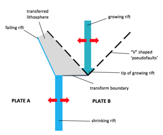
A propagating rift is a seafloor feature associated with spreading centers at mid-ocean ridges and back-arc basins. They are more commonly observed on faster rate spreading centers. These features are formed by the lengthening of one spreading segment at the expense of an offset neighboring spreading segment. Hence, these are remnant features produced by migration of the tip of a spreading center. In other words, as the tip of a spreading center migrates or grows, the plate itself grows at the expense of the shrinking plate, transferring lithosphere from the shrinking plate to the growing plate.
Ridge push is a proposed driving force for plate motion in plate tectonics that occurs at mid-ocean ridges as the result of the rigid lithosphere sliding down the hot, raised asthenosphere below mid-ocean ridges. Although it is called ridge push, the term is somewhat misleading; it is actually a body force that acts throughout an ocean plate, not just at the ridge, as a result of gravitational pull. The name comes from earlier models of plate tectonics in which ridge push was primarily ascribed to upwelling magma at mid-ocean ridges pushing or wedging the plates apart.
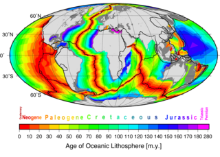
The depth of the seafloor on the flanks of a mid-ocean ridge is determined mainly by the age of the oceanic lithosphere; older seafloor is deeper. During seafloor spreading, lithosphere and mantle cooling, contraction, and isostatic adjustment with age cause seafloor deepening. This relationship has come to be better understood since around 1969 with significant updates in 1974 and 1977. Two main theories have been put forward to explain this observation: one where the mantle including the lithosphere is cooling; the cooling mantle model, and a second where a lithosphere plate cools above a mantle at a constant temperature; the cooling plate model. The cooling mantle model explains the age-depth observations for seafloor younger than 80 million years. The cooling plate model explains the age-depth observations best for seafloor older that 20 million years. In addition, the cooling plate model explains the almost constant depth and heat flow observed in very old seafloor and lithosphere. In practice it is convenient to use the solution for the cooling mantle model for an age-depth relationship younger than 20 million years. Older than this the cooling plate model fits data as well. Beyond 80 million years the plate model fits better than the mantle model.
The plate theory is a model of volcanism that attributes all volcanic activity on Earth, even that which appears superficially to be anomalous, to the operation of plate tectonics. According to the plate theory, the principal cause of volcanism is extension of the lithosphere. Extension of the lithosphere is a function of the lithospheric stress field. The global distribution of volcanic activity at a given time reflects the contemporaneous lithospheric stress field, and changes in the spatial and temporal distribution of volcanoes reflect changes in the stress field. The main factors governing the evolution of the stress field are:
Intraplate volcanism is volcanism that takes place away from the margins of tectonic plates. Most volcanic activity takes place on plate margins, and there is broad consensus among geologists that this activity is explained well by the theory of plate tectonics. However, the origins of volcanic activity within plates remains controversial.
Marine geophysics is the scientific discipline that employs methods of geophysics to study the world's ocean basins and continental margins, particularly the solid earth beneath the ocean. It shares objectives with marine geology, which uses sedimentological, paleontological, and geochemical methods. Marine geophysical data analyses led to the theories of seafloor spreading and plate tectonics.
{{cite book}}
: CS1 maint: location missing publisher (link){{cite book}}
: CS1 maint: location missing publisher (link)