Shallow body of water separated from a larger one by a narrow landform
This article is about the geographical feature. For other uses, see Lagoon (disambiguation).
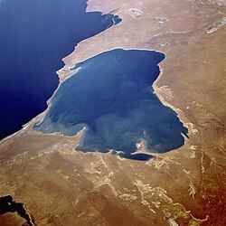
Balos coastal lagoon of northwestern Crete. The shallow lagoon is separated from the Mediterranean Sea by narrow shoals connecting to a small, rocky mountain.Garabogazköl lagoon in TurkmenistanVenetian Lagoon
A lagoon is a shallow body of water separated from a larger body of water by a narrow landform, such as a reef, a barrier island or islands, a barrier peninsula, or an isthmus. Lagoons are commonly divided into coastal lagoons (or barrier lagoons) and atoll lagoons. They have also been identified as occurring on mixed-sand and gravel coastlines. There is an overlap between bodies of water classified as coastal lagoons and bodies of water classified as estuaries. Lagoons are common coastal features around many parts of the world.
Lagoons are shallow, often elongated bodies of water separated from a larger body of water by a shallow or exposed shoal, coral reef, or similar feature. Some authorities include fresh water bodies in the definition of "lagoon", while others explicitly restrict "lagoon" to bodies of water with some degree of salinity. The distinction between "lagoon" and "estuary" also varies between authorities. Richard A. Davis Jr. restricts "lagoon" to bodies of water with little or no fresh water inflow, and little or no tidal flow, and calls any bay that receives a regular flow of fresh water an "estuary". Davis does state that the terms "lagoon" and "estuary" are "often loosely applied, even in scientific literature".[1] Timothy M. Kusky characterizes lagoons as normally being elongated parallel to the coast, while estuaries are usually drowned river valleys, elongated perpendicular to the coast.[1][2][3][4][5] Coastal lagoons are classified as inland bodies of water.[6][7]
When used within the context of a distinctive portion of coral reef ecosystems, the term "lagoon" is synonymous with the term "back reef" or "backreef", which is more commonly used by coral reef scientists to refer to the same area.[8]
In some languages the word for a lagoon is simply a type of lake: In Chinese a lake is hu (湖), and a lagoon is xihu (潟湖). In the French Mediterranean several lagoons are called étang ("lake"). Contrariwise, several other languages have specific words for such bodies of water. In Spanish, coastal lagoons generically are laguna costera, but those on the Mediterranean coast are specifically called albufera. In Russian and Ukrainian, those on the Black Sea are liman (лиман), while the generic word is laguna (Лагуна). Similarly, in the Baltic, Danish has the specific Nor[da], and German the specifics Bodden and Haff, as well as generic terms derived from laguna. In Poland these lagoons are called zalew ("bay"), and in Lithuania marios ("lagoon, reservoir"). In Jutland several lagoons are known as fjord. In New Zealand the Māori word hapua refers to a coastal lagoon formed at the mouth of a braided river where there are mixed sand and gravel beaches, while waituna, an ephemeral coastal waterbody, is neither a true lagoon, lake, nor estuary.[15]
Some languages differentiate between coastal and atoll lagoons. In French, lagon[fr] refers specifically to an atoll lagoon, while coastal lagoons are described as étang[fr], the generic word for a still lake or pond. In Vietnamese, Đầm san hô refers to an atoll lagoon, whilst Đầm phá is coastal.
In Latin America, the term laguna in Spanish, which lagoon translates to, may be used for a small fresh water lake in a similar way a creek is considered a small river. However, sometimes it is popularly used to describe a full-sized lake, such as Laguna Catemaco in Mexico, which is actually the third-largest lake by area in the country. The brackish water lagoon may be thus explicitly identified as a "coastal lagoon" (laguna costera). In Portuguese, a similar usage is found: lagoa may be a body of shallow seawater, or a small freshwater lake not linked to the sea.
Etymology
Lagoon is derived from the Venetianłaguna, which refers to the waters around Venice, i.e. the Venetian Lagoon. Laguna is attested in English by at least 1612, and had been Anglicized to lagune by 1673. In 1697 William Dampier referred to a "Lagune or Lake of Salt water" on the coast of Mexico. Captain James Cook described an island "of Oval form with a Lagoon in the middle" in 1769.[16]
Atoll lagoons form as coral reefs grow upwards while the islands that the reefs surround subside, until eventually only the reefs remain above sea level. Unlike the lagoons that form shoreward of fringing reefs, atoll lagoons often contain some deep (>20m (66ft)) portions.[citation needed]
Coastal lagoons form along gently sloping coasts where barrier islands or reefs can develop offshore, and the sea-level is rising relative to the land along the shore (either because of an intrinsic rise in sea-level, or subsidence of the land along the coast). Coastal lagoons do not form along steep or rocky coasts, or if the range of tides is more than 4 metres (13ft). Due to the gentle slope of the coast, coastal lagoons are shallow. A relative drop in sea level may leave a lagoon largely dry, while a rise in sea level may let the sea breach or destroy barrier islands, and leave reefs too deep underwater to protect the lagoon. Coastal lagoons are young and dynamic, and may be short-lived in geological terms. Coastal lagoons are common, occurring along nearly 15 percent of the world's shorelines. In the United States, lagoons are found along more than 75 percent of the Eastern and Gulf Coasts.[3][4]
Coastal lagoons can be classified as leaky, restricted, or choked.[17] Coastal lagoons are usually connected to the open ocean by inlets between barrier islands. The number and size of the inlets, precipitation, evaporation, and inflow of fresh water all affect the nature of the lagoon. Lagoons with little or no interchange with the open ocean, little or no inflow of fresh water, and high evaporation rates, such as Lake St. Lucia, in South Africa, may become highly saline. Lagoons with no connection to the open ocean and significant inflow of fresh water, such as the Lake Worth Lagoon in Florida in the middle of the 19th century, may be entirely fresh. On the other hand, lagoons with many wide inlets, such as the Wadden Sea, have strong tidal currents and mixing. Coastal lagoons tend to accumulate sediments from inflowing rivers, from runoff from the shores of the lagoon, and from sediment carried into the lagoon through inlets by the tide. Large quantities of sediment may be occasionally be deposited in a lagoon when storm waves overwash barrier islands. Mangroves and marsh plants can facilitate the accumulation of sediment in a lagoon. Benthic organisms may stabilize or destabilize sediments.[3][4]
123Nybakken, James W., ed. (2003). "Lagoon". Interdisciplinary Encyclopedia of Marine Sciences. Vol.2 G-O. Danbury, Connecticut: Grolier Academic Reference. pp.189–90. ISBN0-7172-5946-3.
↑Kirk, R.M. and Lauder, G.A (2000). Significant coastal lagoon systems in the South Island, New Zealand: coastal processes and lagoon mouth closure. Wellington, N.Z.: Department of Conservation. ISBN0-478-21947-4.{{cite book}}: CS1 maint: multiple names: authors list (link)
↑"Lagoon". Oxford English Dictionary. Vol.I A-O (Compacted.). Oxford, England: Oxford University Press. 1971. p.1560.
↑Smith, Ned P. (Summer 2001). "Tides of Biscayne Bay, Card Sound, Little Card Sound, Barnes Sound, and Manatee Bay, Florida". Florida Scientist. 64: 224. JSTOR24321024.
This page is based on this Wikipedia article Text is available under the CC BY-SA 4.0 license; additional terms may apply. Images, videos and audio are available under their respective licenses.


 Aerial view of Bora Bora in French Polynesia.
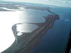 Aerial view of Kivalina, Alaska from the northwest.
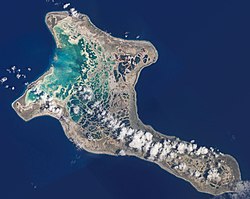 Nearly half the area of Kiritimati is covered with lagoons, some freshwater and some seawater.
 Panoramic view of Lefkada City Lagoon, Lefkada Isl., Ionian Islands Prefecture, Greece.
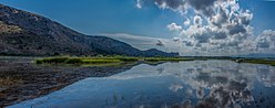 Panoramic view of Prokopos Lagoon, Achaia, Western Greece Prefecture, Greece.
 Tropical lagoon in Bacuit Bay, Palawan, Philippines.
 Photo of Mar Menor as seen from International Space Station.