The Beer–Lambert law is commonly applied to chemical analysis measurements to determine the concentration of chemical species that absorb light. It is often referred to as Beer's law. In physics, the Bouguer–Lambert law is an empirical law which relates the extinction or attenuation of light to the properties of the material through which the light is travelling. It had its first use in astronomical extinction. The fundamental law of extinction is sometimes called the Beer–Bouguer–Lambert law or the Bouguer–Beer–Lambert law or merely the extinction law. The extinction law is also used in understanding attenuation in physical optics, for photons, neutrons, or rarefied gases. In mathematical physics, this law arises as a solution of the BGK equation.

In physics, optical depth or optical thickness is the natural logarithm of the ratio of incident to transmitted radiant power through a material. Thus, the larger the optical depth, the smaller the amount of transmitted radiant power through the material. Spectral optical depth or spectral optical thickness is the natural logarithm of the ratio of incident to transmitted spectral radiant power through a material. Optical depth is dimensionless, and in particular is not a length, though it is a monotonically increasing function of optical path length, and approaches zero as the path length approaches zero. The use of the term "optical density" for optical depth is discouraged.
In physics, attenuation is the gradual loss of flux intensity through a medium. For instance, dark glasses attenuate sunlight, lead attenuates X-rays, and water and air attenuate both light and sound at variable attenuation rates.
The photic zone is the uppermost layer of a body of water that receives sunlight, allowing phytoplankton to perform photosynthesis. It undergoes a series of physical, chemical, and biological processes that supply nutrients into the upper water column. The photic zone is home to the majority of aquatic life due to the activity of the phytoplankton. The thicknesses of the photic and euphotic zones vary with the intensity of sunlight as a function of season and latitude and with the degree of water turbidity. The bottommost, or aphotic, zone is the region of perpetual darkness that lies beneath the photic zone and includes most of the ocean waters.

Turbidity is the cloudiness or haziness of a fluid caused by large numbers of individual particles that are generally invisible to the naked eye, similar to smoke in air. The measurement of turbidity is a key test of both water clarity and water quality.

A nephelometer or aerosol photometer is an instrument for measuring the concentration of suspended particulates in a liquid or gas colloid. A nephelometer measures suspended particulates by employing a light beam and a light detector set to one side of the source beam. Particle density is then a function of the light reflected into the detector from the particles. To some extent, how much light reflects for a given density of particles is dependent upon properties of the particles such as their shape, color, and reflectivity. Nephelometers are calibrated to a known particulate, then use environmental factors (k-factors) to compensate lighter or darker colored dusts accordingly. K-factor is determined by the user by running the nephelometer next to an air sampling pump and comparing results. There are a wide variety of research-grade nephelometers on the market as well as open source varieties.

The Secchi disk, as created in 1865 by Angelo Secchi, is a plain white, circular disk 30 cm (12 in) in diameter used to measure water transparency or turbidity in bodies of water. The disc is mounted on a pole or line and lowered slowly down in the water. The depth at which the disk is no longer visible is taken as a measure of the transparency of the water. This measure is known as the Secchi depth and is related to water turbidity. Since its invention, the disk has also been used in a modified, smaller 20 cm (8 in) diameter, black-and-white design to measure freshwater transparency.

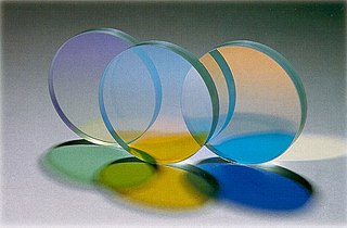
In the field of optics, transparency is the physical property of allowing light to pass through the material without appreciable scattering of light. On a macroscopic scale, the photons can be said to follow Snell's law. Translucency allows light to pass through, but does not necessarily follow Snell's law; the photons can be scattered at either of the two interfaces, or internally, where there is a change in index of refraction. In other words, a translucent material is made up of components with different indices of refraction. A transparent material is made up of components with a uniform index of refraction. Transparent materials appear clear, with the overall appearance of one color, or any combination leading up to a brilliant spectrum of every color. The opposite property of translucency is opacity. Other categories of visual appearance, related to the perception of regular or diffuse reflection and transmission of light, have been organized under the concept of cesia in an order system with three variables, including transparency, translucency and opacity among the involved aspects.
Absorbance is defined as "the logarithm of the ratio of incident to transmitted radiant power through a sample ". Alternatively, for samples which scatter light, absorbance may be defined as "the negative logarithm of one minus absorptance, as measured on a uniform sample". The term is used in many technical areas to quantify the results of an experimental measurement. While the term has its origin in quantifying the absorption of light, it is often entangled with quantification of light which is “lost” to a detector system through other mechanisms. What these uses of the term tend to have in common is that they refer to a logarithm of the ratio of a quantity of light incident on a sample or material to that which is detected after the light has interacted with the sample.
SeaWiFS was a satellite-borne sensor designed to collect global ocean biological data. Active from September 1997 to December 2010, its primary mission was to quantify chlorophyll produced by marine phytoplankton.

In physics, absorption of electromagnetic radiation is how matter takes up a photon's energy — and so transforms electromagnetic energy into internal energy of the absorber.

The color of water varies with the ambient conditions in which that water is present. While relatively small quantities of water appear to be colorless, pure water has a slight blue color that becomes deeper as the thickness of the observed sample increases. The hue of water is an intrinsic property and is caused by selective absorption and scattering of blue light. Dissolved elements or suspended impurities may give water a different color.

MEdium Resolution Imaging Spectrometer (MERIS) was one of the main instruments on board the European Space Agency (ESA)'s Envisat platform. The sensor was in orbit from 2002 to 2012. ESA formally announced the end of Envisat's mission on 9 May 2012.

Underwater vision is the ability to see objects underwater, and this is significantly affected by several factors. Underwater, objects are less visible because of lower levels of natural illumination caused by rapid attenuation of light with distance passed through the water. They are also blurred by scattering of light between the object and the viewer, also resulting in lower contrast. These effects vary with wavelength of the light, and color and turbidity of the water. The vertebrate eye is usually either optimised for underwater vision or air vision, as is the case in the human eye. The visual acuity of the air-optimised eye is severely adversely affected by the difference in refractive index between air and water when immersed in direct contact. Provision of an airspace between the cornea and the water can compensate, but has the side effect of scale and distance distortion. The diver learns to compensate for these distortions. Artificial illumination is effective to improve illumination at short range.

Ocean color is the branch of ocean optics that specifically studies the color of the water and information that can be gained from looking at variations in color. The color of the ocean, while mainly blue, actually varies from blue to green or even yellow, brown or red in some cases. This field of study developed alongside water remote sensing, so it is focused mainly on how color is measured by instruments.

ADEOS I was an Earth observation satellite launched by NASDA in 1996. The mission's Japanese name, Midori means "green". The mission ended in July 1997 after the satellite sustained structural damage to the solar panel. Its successor, ADEOS II, was launched in 2002. Like the first mission, it ended after less than a year, also following solar panel malfunctions.
A closure experiment in atmospheric science is a combination of different measurement techniques to describe the current state of the investigated system as fully as possible, and to find inaccuracies in one or some of the methods involved. The comparison of different types of measurement often involves model calculations, which may also be tested in this process.

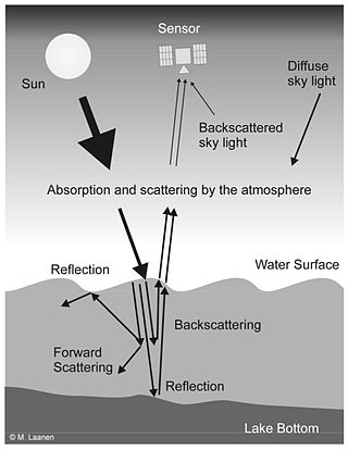
Water Remote Sensing is the observation of water bodies such as lakes, oceans, and rivers from a distance in order to describe their color, state of ecosystem health, and productivity. Water remote sensing studies the color of water through the observation of the spectrum of water leaving radiance. From the spectrum of color coming from the water, the concentration of optically active components of the upper layer of the water body can be estimated via specific algorithms. Water quality monitoring by remote sensing and close-range instruments has obtained considerable attention since the founding of EU Water Framework Directive.

Ocean optics is the study of how light interacts with water and the materials in water. Although research often focuses on the sea, the field broadly includes rivers, lakes, inland waters, coastal waters, and large ocean basins. How light acts in water is critical to how ecosystems function underwater. Knowledge of ocean optics is needed in aquatic remote sensing research in order to understand what information can be extracted from the color of the water as it appears from satellite sensors in space. The color of the water as seen by satellites is known as ocean color. While ocean color is a key theme of ocean optics, optics is a broader term that also includes the development of underwater sensors using optical methods to study much more than just color, including ocean chemistry, particle size, imaging of microscopic plants and animals, and more.

Water clarity is a descriptive term for how deeply visible light penetrates through water. In addition to light penetration, the term water clarity is also often used to describe underwater visibility. Water clarity is one way that humans measure water quality, along with oxygen concentration and the presence or absence of pollutants and algal blooms.


