Native Americans have lived along the Mississippi River and its tributaries for thousands of years. Many were hunter-gatherers, but some, such as the Mound Builders, formed prolific agricultural and urban civilizations, and some practiced aquaculture. The arrival of Europeans in the 16th century changed the native way of life as first explorers, then settlers, ventured into the basin in increasing numbers.[20] The river served sometimes as a barrier, forming borders for New Spain, New France, and the early United States, and throughout as a vital transportation artery and communications link. In the 19th century, during the height of the ideology of manifest destiny, the Mississippi and several tributaries, most notably its largest, the Ohio and Missouri, formed pathways for the western expansion of the United States. The river also became the subject of American literature, particularly in the writings of Mark Twain.
Formed from thick layers of the river's silt deposits, the Mississippi embayment, and American Bottom are some of the most fertile regions of the United States; steamboats were widely used in the 19th and early 20th centuries to ship agricultural and industrial goods. During the American Civil War, the Mississippi's final capture by Union forces marked a turning point to victory for the Union. Because of the substantial growth of cities and the larger ships and barges that replaced steamboats, the first decades of the 20th century saw the construction of massive engineering works such as levees, locks and dams, often built in combination. A major focus of this work has been to prevent the lower Mississippi from shifting into the channel of the Atchafalaya River and bypassing New Orleans.
Since the 20th century, the Mississippi River has also experienced major pollution and environmental problems, most notably elevated nutrient and chemical levels from agricultural runoff, the primary contributor to the Gulf of Mexico dead zone.
Name and significance
The word Mississippi itself comes from Misi zipi, the French rendering of the Anishinaabe (Ojibwe or Algonquin) name for the river, Misi-ziibi (Great River).[21]
In the 18th century, the river was set by the Treaty of Paris as, for the most part, the western border of the new United States. With the Louisiana Purchase and the country's westward expansion, it became a convenient boundary line between the western and eastern halves of the country.[22][23] This is reflected in the Gateway Arch in St. Louis, which was designed to symbolize the opening of the West,[24] and the focus on the "Trans-Mississippi" region in the Trans-Mississippi Exposition.[25]
Regional landmarks are often classified in relation to the river, such as "the highest peak east of the Mississippi"[26] or "the oldest city west of the Mississippi".[27] The FCC also uses it as the dividing line for broadcast call-signs, which begin with W to the east and K to the west, overlapping in media markets along the river.
Due to its size and importance, it has been nicknamed The Mighty Mississippi River or simply The Mighty Mississippi.[28]
Divisions
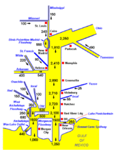
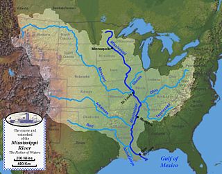
The Mississippi River can be divided into three sections: the Upper Mississippi, the river from its headwaters to the confluence with the Missouri River; the Middle Mississippi, which is downriver from the Missouri to the Ohio River; and the Lower Mississippi, which flows from the Ohio to the Gulf of Mexico.
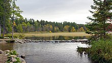
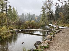
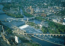
The source of the Mississippi River at Lake ItascaThe first bridge (and only log bridge) over the Mississippi, about 25 feet south of its source at Lake ItascaDe facto head of navigation, St. Anthony Falls, Minneapolis, MinnesotaConfluence of the Wisconsin and Mississippi rivers, viewed from Wyalusing State Park in Wisconsin
The Upper Mississippi runs from its headwaters to its confluence with the Missouri River at St. Louis, Missouri. It is divided into two sections:
The source of the Upper Mississippi branch is traditionally accepted as Lake Itasca, 1,475 feet (450m) above sea level in Itasca State Park in Clearwater County, Minnesota. The name Itasca was chosen to designate the "true head" of the Mississippi River as a combination of the last four letters of the Latin word for truth (veritas) and the first two letters of the Latin word for head (caput).[29] However, the lake is in turn fed by a number of smaller streams.
From its origin at Lake Itasca to St. Louis, Missouri, the waterway's flow is moderated by 43 dams. Fourteen of these dams are located above Minneapolis in the headwaters region and serve multiple purposes, including power generation and recreation. The remaining 29 dams, beginning in downtown Minneapolis, all contain locks and were constructed to improve commercial navigation of the upper river. Taken as a whole, these 43 dams significantly shape the geography and influence the ecology of the upper river. Beginning just below Saint Paul, Minnesota, and continuing throughout the upper and lower river, the Mississippi is further controlled by thousands of wing dikes that moderate the river's flow in order to maintain an open navigation channel and prevent the river from eroding its banks.
The uppermost lock and dam on the Upper Mississippi River is the Upper St. Anthony Falls Lock and Dam in Minneapolis. Above the dam, the river's elevation is 799 feet (244m). Below the dam, the river's elevation is 750 feet (230m). This 49-foot (15m) drop is the largest of all the Mississippi River locks and dams. The origin of the dramatic drop is a waterfall preserved adjacent to the lock under an apron of concrete. Saint Anthony Falls is the only true waterfall on the entire Mississippi River. The water elevation continues to drop steeply as it passes through the gorge carved by the waterfall.
After the completion of the St. Anthony Falls Lock and Dam in 1963, the river's head of navigation moved upstream, to the Coon Rapids Dam. However, the Locks were closed in 2015 to control the spread of invasive Asian carp, making Minneapolis once again the site of the head of navigation of the river.[30]
By the time the Upper Mississippi reaches Saint Paul, Minnesota, below Lock and Dam No. 1, it has dropped more than half its original elevation and is 687 feet (209m) above sea level. From St. Paul to St. Louis, Missouri, the river elevation falls much more slowly and is controlled and managed as a series of pools created by 26 locks and dams.[32]
The Upper Mississippi River at its confluence with the Missouri River north of St. Louis
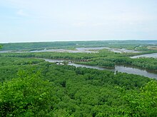
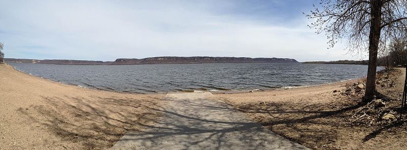
The Upper Mississippi is largely a multi-thread stream with many bars and islands. From its confluence with the St. Croix River downstream to Dubuque, Iowa, the river is entrenched, with high bedrock bluffs lying on either side. The height of these bluffs decreases to the south of Dubuque, though they are still significant through Savanna, Illinois. This topography contrasts strongly with the Lower Mississippi, which is a meandering river in a broad, flat area, only rarely flowing alongside a bluff (as at Vicksburg, Mississippi).
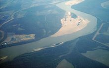
The confluence of the Mississippi (left) and Ohio (right) rivers at Cairo, Illinois, the demarcation between the Middle and the Lower Mississippi River
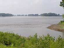
The Middle Mississippi is relatively free-flowing. From St. Louis to the Ohio River confluence, the Middle Mississippi falls 220 feet (67m) over 180 miles (290km) for an average rate of 1.2 feet per mile (23cm/km). At its confluence with the Ohio River, the Middle Mississippi is 315 feet (96m) above sea level. Apart from the Missouri and Meramec rivers of Missouri and the Kaskaskia River of Illinois, no major tributaries enter the Middle Mississippi River.
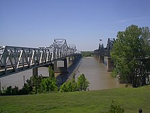
Lower Mississippi River at Algiers Point in New Orleans
The Mississippi River is called the Lower Mississippi River from its confluence with the Ohio River to its mouth at the Gulf of Mexico, a distance of about 1,000 miles (1,600km). At the confluence of the Ohio and the Middle Mississippi, the long-term mean discharge of the Ohio at Cairo, Illinois is 281,500 cubic feet per second (7,970 cubic meters per second),[35] while the long-term mean discharge of the Mississippi at Thebes, Illinois (just upriver from Cairo) is 208,200cuft/s (5,900m3/s).[36] Thus, by volume, the main branch of the Mississippi River system at Cairo can be considered to be the Ohio River (and the Allegheny River further upstream), rather than the Middle Mississippi.
Deliberate water diversion at the Old River Control Structure in Louisiana allows the Atchafalaya River in Louisiana to be a major distributary of the Mississippi River, with 30% of the combined flow of the Mississippi and Red Rivers flowing to the Gulf of Mexico by this route, rather than continuing down the Mississippi's current channel past Baton Rouge and New Orleans on a longer route to the Gulf.[37][38][39][40] Although the Red River was once an additional tributary, its water now flows separately into the Gulf of Mexico through the Atchafalaya River.[41]
Watershed
Map of the Mississippi River watershedAn animation of the flows along the rivers of the Mississippi watershed
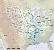
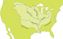
The Mississippi River has the world's fourth-largest drainage basin ("watershed" or "catchment"). The basin covers more than 1,245,000 square miles (3,220,000km2), including all or parts of 32 U.S. states and two Canadian provinces. The drainage basin empties into the Gulf of Mexico, part of the Atlantic Ocean. The total catchment of the Mississippi River covers nearly 40% of the landmass of the continental United States. The highest point within the watershed is also the highest point of the Rocky Mountains, Mount Elbert at 14,440 feet (4,400m).[42]
Sequence of NASA MODIS images showing the outflow of fresh water from the Mississippi (arrows) into the Gulf of Mexico (2004)
The Mississippi River empties into the Gulf of Mexico about 100 miles (160km) downstream from New Orleans. Measurements of the length of the Mississippi from Lake Itasca to the Gulf of Mexico vary somewhat, but the United States Geological Survey's number is 2,340 miles (3,766km). The retention time from Lake Itasca to the Gulf is typically about 90 days;[43] while speed varies along the course of the river, this gives an overall average of around 26mi (42km) per day, or 1mi (1.6km) per hour.
The Mississippi River discharges at an annual average rate of between 200 and 700thousand cubic feet per second (6,000 and 20,000m3/s).[44] The Mississippi is the fourteenth largest river in the world by volume. On average, the Mississippi has 8% the flow of the Amazon River,[45] which moves nearly 7million cubic feet per second (200,000m3/s) during wet seasons.
Before 1900, the Mississippi River transported an estimated 440million short tons (400million metric tons) of sediment per year from the interior of the United States to coastal Louisiana and the Gulf of Mexico. During the last two decades, this number was only 160million short tons (145million metric tons) per year. The reduction in sediment transported down the Mississippi River is the result of engineering modification of the Mississippi, Missouri, and Ohio rivers and their tributaries by dams, meander cutoffs, river-training structures, and bank revetments and soil erosion control programs in the areas drained by them.[46]
Mixing with salt water
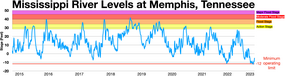
Denser salt water from the Gulf of Mexico forms a salt wedge along the river bottom near the mouth of the river, while fresh water flows near the surface. In drought years, with less fresh water to push it out, salt water can travel many miles upstream—64 miles (103km) in 2022—contaminating drinking water supplies and requiring the use of desalination. The United States Army Corps of Engineers constructed "saltwater sills" or "underwater levees" to contain this in 1988, 1999, 2012, and 2022. This consists of a large mound of sand spanning the width of the river 55 feet below the surface, allowing fresh water and large cargo ships to pass over.[47]
Fresh river water flowing from the Mississippi into the Gulf of Mexico does not mix into the salt water immediately. The images from NASA's MODIS show a large plume of fresh water, which appears as a dark ribbon against the lighter-blue surrounding waters. These images demonstrate that the plume did not mix with the surrounding sea water immediately. Instead, it stayed intact as it flowed through the Gulf of Mexico, into the Straits of Florida, and entered the Gulf Stream. The Mississippi River water rounded the tip of Florida and traveled up the southeast coast to the latitude of Georgia before finally mixing in so thoroughly with the ocean that it could no longer be detected by MODIS.
Course changes
Over geologic time, the Mississippi River has experienced numerous large and small changes to its main course, as well as additions, deletions, and other changes among its numerous tributaries, and the lower Mississippi River has used different pathways as its main channel to the Gulf of Mexico across the delta region.
As Pangaea began to break up about 95 million years ago, North America passed over a volcanic "hotspot" in the Earth's mantle (specifically, the Bermuda hotspot) that was undergoing a period of intense activity. The upwelling of magma from the hotspot forced the further uplift to a height of perhaps 2–3km of part of the Appalachian-Ouachita range, forming an arch that blocked southbound water flows. The uplifted land quickly eroded and, as North America moved away from the hot spot and as the hotspot's activity declined, the crust beneath the embayment region cooled, contracted and subsided to a depth of 2.6km, and around 80 million years ago the Reelfoot Rift formed a trough that was flooded by the Gulf of Mexico. As sea levels dropped, the Mississippi and other rivers extended their courses into the embayment, which gradually became filled with sediment with the Mississippi River at its center.[48][49]
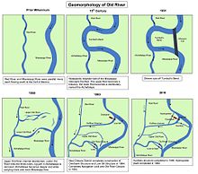
Through a natural process known as avulsion or delta switching, the lower Mississippi River has shifted its final course to the mouth of the Gulf of Mexico every thousand years or so. This occurs because the deposits of silt and sediment begin to clog its channel, raising the river's level and causing it to eventually find a steeper, more direct route to the Gulf of Mexico. The abandoned distributaries diminish in volume and form what are known as bayous. This process has, over the past 5,000 years, caused the coastline of south Louisiana to advance toward the Gulf from 15 to 50 miles (24 to 80km). The currently active delta lobe is called the Birdfoot Delta, after its shape, or the Balize Delta, after La Balize, Louisiana, the first French settlement at the mouth of the Mississippi.
Prehistoric courses
The current form of the Mississippi River basin was largely shaped by the Laurentide Ice Sheet of the most recentIce Age. The southernmost extent of this enormous glaciation extended well into the present-day United States and Mississippi basin. When the ice sheet began to recede, hundreds of feet of rich sediment were deposited, creating the flat and fertile landscape of the Mississippi Valley. During the melt, giant glacial rivers found drainage paths into the Mississippi watershed, creating such features as the Minnesota River, James River, and Milk River valleys. When the ice sheet completely retreated, many of these "temporary" rivers found paths to Hudson Bay or the Arctic Ocean, leaving the Mississippi Basin with many features "over-sized" for the existing rivers to have carved in the same time period.
Ice sheets during the Illinoian Stage, about 300,000 to 132,000 years before present, blocked the Mississippi near Rock Island, Illinois, diverting it to its present channel farther to the west, the current western border of Illinois. The Hennepin Canal roughly follows the ancient channel of the Mississippi downstream from Rock Island to Hennepin, Illinois. South of Hennepin, to Alton, Illinois, the current Illinois River follows the ancient channel used by the Mississippi River before the Illinoian Stage.[50][51]
c. 5000 BC: The last ice age ended; world sea level became what it is now.
c. 2500 BC: Bayou Teche became the main course of the Mississippi.
c. 800 BC: The Mississippi diverted further east.
c. 200 AD: Bayou Lafourche became the main course of the Mississippi.
c. 1000 AD: The Mississippi's present course took over.
Before c. 1400 AD: The Red River of the South flowed parallel to the lower Mississippi to the sea
15th century: Turnbull's Bend in the lower Mississippi extended so far west that it captured the Red River of the South. The Red River below the captured section became the Atchafalaya River.
1831: Captain Henry M. Shreve dug a new short course for the Mississippi through the neck of Turnbull's Bend.
1833 to November 1873: The Great Raft (a huge logjam in the Atchafalaya River) was cleared. The Atchafalaya started to capture the Mississippi and to become its new main lower course.
1963: The Old River Control Structure was completed, controlling how much Mississippi water entered the Atchafalaya.
Historic course changes
Visual guide to Mississippi River nomenclature
In March 1876, the Mississippi suddenly changed course near the settlement of Reverie, Tennessee, leaving a small part of Tipton County, Tennessee, attached to Arkansas and separated from the rest of Tennessee by the new river channel. Since this event was an avulsion, rather than the effect of incremental erosion and deposition, the state line still follows the old channel.[53]
The town of Kaskaskia, Illinois once stood on a peninsula at the confluence of the Mississippi and Kaskaskia (Okaw) Rivers. Founded as a French colonial community, it later became the capital of the Illinois Territory and was the first state capital of Illinois until 1819. Beginning in 1844, successive flooding caused the Mississippi River to slowly encroach east. A major flood in 1881 caused it to overtake the lower 10 miles (16km) of the Kaskaskia River, forming a new Mississippi channel and cutting off the town from the rest of the state. Later flooding destroyed most of the remaining town, including the original State House. Today, the remaining 2,300 acres (930ha) island and community of 14 residents is known as an enclave of Illinois and is accessible only from the Missouri side.[54]
New Madrid Seismic Zone
The New Madrid Seismic Zone, along the Mississippi River near New Madrid, Missouri, between Memphis and St. Louis, is related to an aulacogen (failed rift) that formed at the same time as the Gulf of Mexico. This area is still quite active seismically. Four great earthquakes in 1811 and 1812, estimated at 8 on the Richter magnitude scale, had tremendous local effects in the then sparsely settled area, and were felt in many other places in the Midwestern and eastern U.S. These earthquakes created Reelfoot Lake in Tennessee from the altered landscape near the river.
Length
When measured from its traditional source at Lake Itasca, the Mississippi has a length of 2,340 miles (3,766km). When measured from its longest stream source (most distant source from the sea), Brower's Spring in Montana, the source of the Missouri River, it has a length of 3,710 miles (5,971km), making it the fourth longest river in the world after the Nile, Amazon, and Yangtze.[55] When measured by the largest stream source (by water volume), the Ohio River, by extension the Allegheny River, would be the source, and the Mississippi would begin in Pennsylvania.[56]
Depth
At its source at Lake Itasca, the Mississippi River is about 3 feet (0.91m) deep. The average depth of the Mississippi River between Saint Paul and Saint Louis is between 9 and 12 feet (2.7–3.7m) deep, the deepest part being Lake Pepin, which averages 20–32 feet (6–10m) deep and has a maximum depth of 60 feet (18m). Between where the Missouri River joins the Mississippi at Saint Louis, Missouri, and Cairo, Illinois, the depth averages 30 feet (9m). Below Cairo, where the Ohio River joins, the depth averages 50–100 feet (15–30m) deep. The deepest part of the river is in New Orleans, where it reaches 200 feet (61m) deep.[57][58]
Cultural geography
State boundaries
The Mississippi River runs through or along 10 states, from Minnesota to Louisiana, and is used to define portions of these states' borders, with Wisconsin, Illinois, Kentucky, Tennessee, and Mississippi along the east side of the river, and Iowa, Missouri, and Arkansas along its west side. Substantial parts of both Minnesota and Louisiana are on either side of the river, although the Mississippi defines part of the boundary of each of these states.
In all of these cases, the middle of the riverbed at the time the borders were established was used as the line to define the borders between adjacent states.[59][60] In various areas, the river has since shifted, but the state borders have not changed, still following the former bed of the Mississippi River as of their establishment, leaving several small isolated areas of one state across the new river channel, contiguous with the adjacent state. Also, due to a meander in the river, a small part of western Kentucky is contiguous with Tennessee but isolated from the rest of its state.
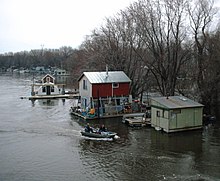
Community of boathouses on the Mississippi River in Winona, MN (2006)The Mississippi River at the Chain of Rocks just north of St. Louis (2005)A low-water dam deepens the pool above the Chain of Rocks Lock near St. Louis (2006)
The road crossing highest on the Upper Mississippi is a simple steel culvert, through which the river (locally named "Nicolet Creek") flows north from Lake Nicolet under "Wilderness Road" to the West Arm of Lake Itasca, within Itasca State Park.[62]
The earliest bridge across the Mississippi River was built in 1855. It spanned the river in Minneapolis where the current Hennepin Avenue Bridge is located.[63] No highway or railroad tunnels cross under the Mississippi River.
The first railroad bridge across the Mississippi was built in 1856. It spanned the river between the Rock Island Arsenal in Illinois and Davenport, Iowa. Steamboat captains of the day, fearful of competition from the railroads, considered the new bridge a hazard to navigation. Two weeks after the bridge opened, the steamboat Effie Afton rammed part of the bridge, setting it on fire. Legal proceedings ensued, with Abraham Lincoln defending the railroad. The lawsuit went to the Supreme Court of the United States, which ruled in favor of the railroad.[64]
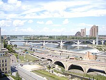
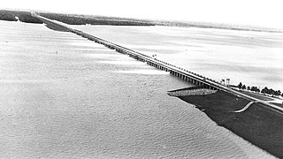
Below is a general overview of selected Mississippi bridges that have notable engineering or landmark significance, with their cities or locations. They are sequenced from the Upper Mississippi's source to the Lower Mississippi's mouth.
Chain of Rocks Bridge–Located on the northern edge of St. Louis, notable for a 22-degree bend occurring at the middle of the crossing, necessary for navigation on the river; formerly used by U.S. Route 66 to cross the Mississippi. Replaced for road traffic in 1966 by a nearby pair of new bridges; now a pedestrian bridge.
Eads Bridge–A combined road and railway bridge, connecting St. Louis and East St. Louis, Illinois. When completed in 1874, it was the longest arch bridge in the world, with an overall length of 6,442 feet (1,964m). The three ribbed steel arch spans were considered daring, as was the use of steel as a primary structural material; it was the first such use of true steel in a major bridge project.
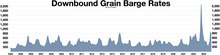
Downbound barge rates In late 2022 there was low river levels that caused two backups on the Lower Mississippi River that held up over 100 tow boats with 2,000 barge units and caused barge rates to soar
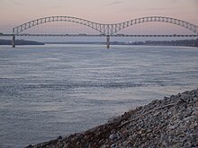
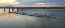
Towboat and barges at Memphis, TennesseeShips on the lower part of the Mississippi
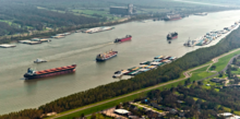
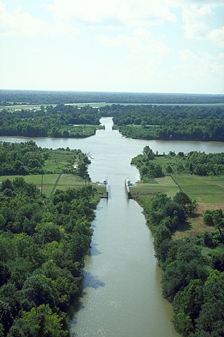
A clear channel is needed for the barges and other vessels that make the main stem Mississippi one of the great commercial waterways of the world. The task of maintaining a navigation channel is the responsibility of the United States Army Corps of Engineers, which was established in 1802.[67] Earlier projects began as early as 1829 to remove snags, close off secondary channels and excavate rocks and sandbars.
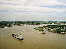
Oil tanker on the Lower Mississippi near the Port of New OrleansBarge on the Lower Mississippi River
The upper backwaters of the Mississippi normally freeze over by December, while the main channel freezes over only in the coldest years, historically as far south as St. Louis.[68]
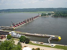
A series of 29 locks and dams on the upper Mississippi, most of which were built in the 1930s, is designed primarily to maintain a 9-foot-deep (2.7m) channel for commercial barge traffic.[69][70] The lakes formed are also used for recreational boating and fishing. The dams make the river deeper and wider but do not stop it. No flood control is intended. During periods of high flow, the gates, some of which are submersible, are completely opened and the dams simply cease to function. Below St. Louis, the Mississippi is relatively free-flowing, although it is constrained by numerous levees and directed by numerous wing dams. The scope and scale of the levees, built along either side of the river to keep it on its course, has often been compared to the Great Wall of China.[37]
On the lower Mississippi, from Baton Rouge to the mouth of the Mississippi, the navigation depth is 45 feet (14m), allowing container ships and cruise ships to dock at the Port of New Orleans and bulk cargo ships shorter than 150-foot (46m) air draft that fit under the Huey P. Long Bridge to traverse the Mississippi to Baton Rouge.[71] There is a feasibility study to dredge this portion of the river to 50 feet (15m) to allow New Panamax ship depths.[72]
In 1829, there were surveys of the two major obstacles on the upper Mississippi, the Des Moines Rapids and the Rock Island Rapids, where the river was shallow and the riverbed was rock. The Des Moines Rapids were about 11 miles (18km) long and just above the mouth of the Des Moines River at Keokuk, Iowa. The Rock Island Rapids were between Rock Island and Moline, Illinois. Both rapids were considered virtually impassable.
In 1848, the Illinois and Michigan Canal was built to connect the Mississippi River to Lake Michigan via the Illinois River near Peru, Illinois. The canal allowed shipping between these important waterways. In 1900, the canal was replaced by the Chicago Sanitary and Ship Canal. The second canal, in addition to shipping, also allowed Chicago to address specific health issues (typhoid fever, cholera and other waterborne diseases) by sending its waste down the Illinois and Mississippi river systems rather than polluting its water source of Lake Michigan.
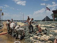
Laborers fighting a "crevasse" in a riverfront levee that will flood the adjacent agricultural land if not repaired (Picturesque America, 1872)
The Corps of Engineers recommended the excavation of a 5-foot-deep (1.5m) channel at the Des Moines Rapids, but work did not begin until after Lieutenant Robert E. Lee endorsed the project in 1837. The Corps later also began excavating the Rock Island Rapids. By 1866, it had become evident that excavation was impractical, and it was decided to build a canal around the Des Moines Rapids. The canal opened in 1877, but the Rock Island Rapids remained an obstacle. In 1878, Congress authorized the Corps to establish a 4.5-foot-deep (1.4m) channel to be obtained by building wing dams that direct the river to a narrow channel causing it to cut a deeper channel, by closing secondary channels and by dredging. The channel project was complete when the Moline Lock, which bypassed the Rock Island Rapids, opened in 1907.
To improve navigation between St. Paul, Minnesota, and Prairie du Chien, Wisconsin, the Corps constructed several dams on lakes in the headwaters area, including Lake Winnibigoshish and Lake Pokegama. The dams, which were built beginning in the 1880s, stored spring run-off which was released during low water to help maintain channel depth.
In 1907, Congress authorized a 6-foot-deep (1.8m) channel project on the Mississippi River, which was not complete when it was abandoned in the late 1920s in favor of the 9-foot-deep (2.7m) channel project.
Before the Great Mississippi Flood of 1927, the Corps's primary strategy was to close off as many side channels as possible to increase the flow in the main river. It was thought that the river's velocity would scour off bottom sediments, deepening the river and decreasing the possibility of flooding. The 1927 flood proved this to be so wrong that communities threatened by the flood began to create their own levee breaks to relieve the force of the rising river.
The Rivers and Harbors Act of 1930 authorized the 9-foot (2.7m) channel project, which called for a navigation channel 9 feet (2.7m) feet deep and 400 feet (120m) wide to accommodate multiple-barge tows.[73][74] This was achieved by a series of locks and dams, and by dredging. Twenty-three new locks and dams were built on the upper Mississippi in the 1930s in addition to the three already in existence.
Formation of the Atchafalaya River and construction of the Old River Control Structure.Project design flood flow capacity for the Mississippi river in thousands of cubic feet per second.
Until the 1950s, there was no dam below Lock and Dam 26 at Alton, Illinois. Chain of Rocks Lock (Lock and Dam No. 27), which consists of a low-water dam and an 8.4-mile-long (13.5km) canal, was added in 1953, just below the confluence with the Missouri River, primarily to bypass a series of rock ledges at St. Louis. It also serves to protect the St. Louis city water intakes during times of low water.
U.S. government scientists determined in the 1950s that the Mississippi River was starting to switch to the Atchafalaya River channel because of its much steeper path to the Gulf of Mexico. Eventually, the Atchafalaya River would capture the Mississippi River and become its main channel to the Gulf of Mexico, leaving New Orleans on a side channel. As a result, the U.S. Congress authorized a project called the Old River Control Structure, which has prevented the Mississippi River from leaving its current channel that drains into the Gulf via New Orleans.[76]
Because the large scale of high-energy water flow threatened to damage the structure, an auxiliary flow control station was built adjacent to the standing control station. This $300million project was completed in 1986 by the Corps of Engineers. Beginning in the 1970s, the Corps applied hydrological transport models to analyze flood flow and water quality of the Mississippi. Dam 26 at Alton, Illinois, which had structural problems, was replaced by the Mel Price Lock and Dam in 1990. The original Lock and Dam 26 was demolished.
Some of the pre-1927 strategy remains in use today, with the Corps actively cutting the necks of horseshoe bends, allowing the water to move faster and reducing flood heights.[78]
History
Approximately 50,000 years ago, the Central United States was covered by an inland sea, which was drained by the Mississippi and its tributaries into the Gulf of Mexico—creating large floodplains and extending the continent further to the south in the process. The soil in areas such as Louisiana was thereafter found to be very rich.[79]
A network of trade routes referred to as the Hopewell interaction sphere was active along the waterways between about 200 and 500 AD, spreading common cultural practices over the entire area between the Gulf of Mexico and the Great Lakes. A period of more isolated communities followed, and agriculture introduced from Mesoamerica based on the Three Sisters (maize, beans and squash) gradually came to dominate. After around 800 AD there arose an advanced agricultural society today referred to as the Mississippian culture, with evidence of highly stratifiedcomplexchiefdoms and large population centers.
The most prominent of these, now called Cahokia, was occupied between about 600 and 1400 AD[81] and at its peak numbered between 8,000 and 40,000 inhabitants, larger than London, England of that time. At the time of first contact with Europeans, Cahokia and many other Mississippian cities had dispersed, and archaeological finds attest to increased social stress.[82][83][84]
The word Mississippi itself comes from Messipi, the French rendering of the Anishinaabe (Ojibwe or Algonquin) name for the river, Misi-ziibi (Great River).[85][86] The Ojibwe called Lake Itasca Omashkoozo-zaaga'igan (Elk Lake) and the river flowing out of it Omashkoozo-ziibi (Elk River). After flowing into Lake Bemidji, the Ojibwe called the river Bemijigamaag-ziibi (River from the Traversing Lake). After flowing into Cass Lake, the name of the river changes to Gaa-miskwaawaakokaag-ziibi (Red Cedar River) and then out of Lake Winnibigoshish as Wiinibiigoonzhish-ziibi (Miserable Wretched Dirty Water River), Gichi-ziibi (Big River) after the confluence with the Leech Lake River, then finally as Misi-ziibi (Great River) after the confluence with the Crow Wing River.[87] After the expeditions by Giacomo Beltrami and Henry Schoolcraft, the longest stream above the juncture of the Crow Wing River and Gichi-ziibi was named "Mississippi River". The Mississippi River Band of Chippewa Indians, known as the Gichi-ziibiwininiwag, are named after the stretch of the Mississippi River known as the Gichi-ziibi. The Cheyenne, one of the earliest inhabitants of the upper Mississippi River, called it the Máʼxe-éʼometaaʼe (Big Greasy River) in the Cheyenne language. The Arapaho name for the river is Beesniicíe.[88] The Pawnee name is Kickaátit.[89]
The Mississippi was spelled Mississipi or Missisipi during French Louisiana and was also known as the Rivière Saint-Louis.[90][91][92]
In 1519 Spanish explorer Alonso Álvarez de Pineda became the first recorded European to reach the Mississippi River, followed by Hernando de Soto who reached the river on May 8, 1541, and called it Río del Espíritu Santo ("River of the Holy Spirit"), in the area of what is now Mississippi.[93] In Spanish, the river is called Río Mississippi.[94]
When Louis Jolliet explored the Mississippi Valley in the 17th century, natives guided him to a quicker way to return to French Canada via the Illinois River. When he found the Chicago Portage, he remarked that a canal of "only half a league" (less than 2 miles or 3 kilometers) would join the Mississippi and the Great Lakes.[95] In 1848, the continental divide separating the waters of the Great Lakes and the Mississippi Valley was breached by the Illinois and Michigan canal via the Chicago River.[96] This both accelerated the development, and forever changed the ecology of the Mississippi Valley and the Great Lakes.
In 1718, about 100 miles (160km) upriver, New Orleans was established along the river crescent by Jean-Baptiste Le Moyne, Sieur de Bienville, with construction patterned after the 1711 resettlement on Mobile Bay of Mobile, the capital of French Louisiana at the time.
In 1727, Étienne Perier begins work, using enslaved African laborers, on the first levees on the Mississippi River.
Article 8 of the Treaty of Paris (1783) states, "The navigation of the river Mississippi, from its source to the ocean, shall forever remain free and open to the subjects of Great Britain and the citizens of the United States". With this treaty, which ended the American Revolutionary War, Britain also ceded West Florida back to Spain to regain the Bahamas, which Spain had occupied during the war. Initial disputes around the ensuing claims of the U.S. and Spain were resolved when Spain was pressured into signing Pinckney's Treaty in 1795. However, in 1800, under duress from Napoleon of France, Spain ceded an undefined portion of West Florida to France in the secret Treaty of San Ildefonso. The United States then secured effective control of the river when it bought the Louisiana Territory from France in the Louisiana Purchase of 1803. This triggered a dispute between Spain and the U.S. on which parts of West Florida Spain had ceded to France in the first place, which would decide which parts of West Florida the U.S. had bought from France in the Louisiana Purchase, versus which were unceded Spanish property. Due to ongoing U.S. colonization creating facts on the ground, and U.S. military actions, Spain ceded both West and East Florida in their entirety to the United States in the Adams–Onís Treaty of 1819.
The United States used a motley crew to defend the mouth of the Mississippi River in 1815; forces included Tennessee and Kentucky militiamen, free men of color, French Creoles, Choctaw Indians, slave-trading privateers based out of Galveston, and Mississippi plantation slaves recruited to dig earthworks for "Line Jackson"
The last serious European challenge to U.S. control of the river came at the conclusion of the War of 1812, when British forces mounted an attack on New Orleans just 15 days after the signing of the Treaty of Ghent. The attack was repulsed by an American army under the command of General Andrew Jackson.
In the Treaty of 1818, the U.S. and Great Britain agreed to fix the border running from the Lake of the Woods to the Rocky Mountains along the 49th parallel north. In effect, the U.S. ceded the northwestern extremity of the Mississippi basin to the British in exchange for the southern portion of the Red River basin.
So many settlers traveled westward through the Mississippi river basin, as well as settled in it, that Zadok Cramer wrote a guidebook called The Navigator, detailing the features, dangers, and navigable waterways of the area. It was so popular that he updated and expanded it through 12 editions over 25 years.
Shifting sand bars made early navigation difficult.
Mark Twain's book, Life on the Mississippi, covered the steamboat commerce, which took place from 1830 to 1870, before more modern ships replaced the steamer. Harper's Weekly first published the book as a seven-part serial in 1875. James R. Osgood & Company published the full version, including a passage from the then unfinished Adventures of Huckleberry Finn and works from other authors, in 1885.
The first steamboat to travel the full length of the Lower Mississippi from the Ohio River to New Orleans was the New Orleans in December 1811. Its maiden voyage occurred during the series of New Madrid earthquakes in 1811–12. The Upper Mississippi was treacherous, unpredictable and to make traveling worse, the area was not properly mapped out or surveyed. Until the 1840s, only two trips a year to the Twin Cities landings were made by steamboats, which suggests it was not very profitable.[99]
Steamboat transport remained a viable industry, both in terms of passengers and freight, until the end of the first decade of the 20th century. Among the several Mississippi River system steamboat companies was the noted Anchor Line, which, from 1859 to 1898, operated a luxurious fleet of steamers between St. Louis and New Orleans.
Italian explorer Giacomo Beltrami wrote about his journey on the Virginia, which was the first steamboat to make it to Fort St. Anthony in Minnesota. He referred to his voyage as a promenade that was once a journey on the Mississippi. The steamboat era changed the economic and political life of the Mississippi, as well as of travel itself. The Mississippi was completely changed by the steamboat era as it transformed into a flourishing tourist trade.[100]
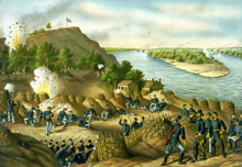
Control of the river was a strategic objective of both sides in the American Civil War, forming a part of the U.S. Anaconda Plan. In 1862, Union forces coming down the river successfully cleared Confederate defenses at Island Number 10 and Memphis, Tennessee, while Naval forces coming upriver from the Gulf of Mexico captured New Orleans, Louisiana. One of the last major Confederate strongholds was on the heights overlooking the river at Vicksburg, Mississippi; the Union's Vicksburg Campaign (December 1862 – July 1863), and the fall of Port Hudson, completed control of the lower Mississippi River. The Union victory ended the Siege of Vicksburg on July 4, 1863, and was pivotal to the Union's final victory of the Civil War.[101]
The "Big Freeze" of 1918–19 blocked river traffic north of Memphis, Tennessee, preventing transportation of coal from southern Illinois. This resulted in widespread shortages, high prices, and rationing of coal in January and February.[102]
In the spring of 1927, the river broke out of its banks in 145 places, during the Great Mississippi Flood of 1927 and inundated 27,000sqmi (70,000km2) to a depth of up to 30 feet (9.1m).
In 1930, Fred Newton was the first person to swim the length of the river, from Minneapolis to New Orleans. The journey took 176 days and covered 1,836 miles.[103][104]
In 1962 and 1963, industrial accidents spilled 3.5million US gallons (13,000m3) of soybean oil into the Mississippi and Minnesota rivers. The oil covered the Mississippi River from St. Paul to Lake Pepin, creating an ecological disaster and a demand to control water pollution.[105]
On October 20, 1976, the automobile ferry, MV George Prince, was struck by a ship traveling upstream as the ferry attempted to cross from Destrehan, Louisiana, to Luling, Louisiana. Seventy-eight passengers and crew died; only eighteen survived the accident.
In 1988, the water level of the Mississippi fell to 10 feet (3.0m) below zero on the Memphis gauge. The remains of wooden-hulled water craft were exposed in an area of 4.5 acres (1.8ha) on the bottom of the Mississippi River at West Memphis, Arkansas. They dated to the late 19th to early 20th centuries. The State of Arkansas, the Arkansas Archeological Survey, and the Arkansas Archeological Society responded with a two-month data recovery effort. The fieldwork received national media attention as good news in the middle of a drought.[106]
The Great Flood of 1993 was another significant flood, primarily affecting the Mississippi above its confluence with the Ohio River at Cairo, Illinois.
Two portions of the Mississippi were designated as American Heritage Rivers in 1997: the lower portion around Louisiana and Tennessee, and the upper portion around Iowa, Illinois, Minnesota, Missouri and Wisconsin. The Nature Conservancy's project called "America's Rivershed Initiative" announced a 'report card' assessment of the entire basin in October 2015 and gave the grade of D+. The assessment noted the aging navigation and flood control infrastructure along with multiple environmental problems.[107]
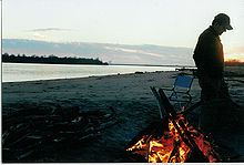
Campsite at the river in Arkansas
In 2002, Slovenian long-distance swimmer Martin Strel swam the entire length of the river, from Minnesota to Louisiana, over the course of 68 days. In 2005, the Source to Sea Expedition[108] paddled the Mississippi and Atchafalaya Rivers to benefit the Audubon Society's Upper Mississippi River Campaign.[109][110]
Future
Geologists believe that the lower Mississippi could take a new course to the Gulf. Either of two new routes—through the Atchafalaya Basin or through Lake Pontchartrain—might become the Mississippi's main channel if flood-control structures are overtopped or heavily damaged during a severe flood.[111][112][113][114][115]
Failure of the Old River Control Structure, the Morganza Spillway, or nearby levees would likely re-route the main channel of the Mississippi through Louisiana's Atchafalaya Basin and down the Atchafalaya River to reach the Gulf of Mexico south of Morgan City in southern Louisiana. This route provides a more direct path to the Gulf of Mexico than the present Mississippi River channel through Baton Rouge and New Orleans.[113] While the risk of such a diversion is present during any major flood event, such a change has so far been prevented by active human intervention involving the construction, maintenance, and operation of various levees, spillways, and other control structures by the U.S. Army Corps of Engineers.
The Old River Control Structure complex. View is to the east-southeast, looking downriver on the Mississippi, with the three dams across channels of the Atchafalaya River to the right of the Mississippi. Concordia Parish, Louisiana is in the foreground, on the right, and Wilkinson County, Mississippi, is in the background, across the Mississippi on the left.
The Old River Control Structure, between the present Mississippi River channel and the Atchafalaya Basin, sits at the normal water elevation and is ordinarily used to divert 30% of the Mississippi flow to the Atchafalaya River. There is a steep drop here away from the Mississippi's main channel into the Atchafalaya Basin. If this facility were to fail during a major flood, there is a strong concern the water would scour and erode the river bottom enough to capture the Mississippi's main channel. The structure was nearly lost during the 1973 flood, but repairs and improvements were made after engineers studied the forces at play. In particular, the Corps of Engineers made many improvements and constructed additional facilities for routing water through the vicinity. These additional facilities give the Corps much more flexibility and potential flow capacity than they had in 1973, which further reduces the risk of a catastrophic failure in this area during other major floods, such as that of 2011.
Because the Morganza Spillway is slightly higher and well back from the river, it is normally dry on both sides.[116] Even if it failed at the crest during a severe flood, the floodwaters would have to erode to normal water levels before the Mississippi could permanently jump channel at this location.[117][118] During the 2011 floods, the Corps of Engineers opened the Morganza Spillway to 1/4 of its capacity to allow 150,000 cubic feet per second (4,200m3/s) of water to flood the Morganza and Atchafalaya floodways and continue directly to the Gulf of Mexico, bypassing Baton Rouge and New Orleans.[119] In addition to reducing the Mississippi River crest downstream, this diversion reduced the chances of a channel change by reducing stress on the other elements of the control system.[120]
Some geologists have noted that the possibility for course change into the Atchafalaya also exists in the area immediately north of the Old River Control Structure. Army Corps of Engineers geologist Fred Smith once stated, "The Mississippi wants to go west. 1973 was a forty-year flood. The big one lies out there somewhere—when the structures can't release all the floodwaters and the levee is going to have to give way. That is when the river's going to jump its banks and try to break through."[121]
Another possible course change for the Mississippi River is a diversion into Lake Pontchartrain near New Orleans. This route is controlled by the Bonnet Carré Spillway, built to reduce flooding in New Orleans. This spillway and an imperfect natural levee about 12–20ft (3.7–6.1m) high are all that prevents the Mississippi from taking a new, shorter course through Lake Pontchartrain to the Gulf of Mexico.[122] Diversion of the Mississippi's main channel through Lake Pontchartrain would have consequences similar to an Atchafalaya diversion, but to a lesser extent, since the present river channel would remain in use past Baton Rouge and into the New Orleans area.
The sport of water skiing was invented on the river in a wide region between Minnesota and Wisconsin known as Lake Pepin.[123]Ralph Samuelson of Lake City, Minnesota, created and refined his skiing technique in late June and early July 1922. He later performed the first water ski jump in 1925 and was pulled along at 80mph (130km/h) by a Curtiss flying boat later that year.[123]
There are seven National Park Service sites along the Mississippi River. The Mississippi National River and Recreation Area is the National Park Service site dedicated to protecting and interpreting the Mississippi River itself. The other six National Park Service sites along the river are (listed from north to south):
The Mississippi basin is home to a highly diverse aquatic fauna and has been called the "mother fauna" of North American freshwater.[124]
Fish
About 375 fish species are known from the Mississippi basin, far exceeding other North Hemisphere river basins exclusively within temperate/subtropical regions,[124] except the Yangtze.[125] Within the Mississippi basin, streams that have their source in the Appalachian and Ozark highlands contain especially many species. Among the fish species in the basin are numerous endemics, as well as relicts such as paddlefish, sturgeon, gar and bowfin.[124]
A large number of reptiles are native to the river channels and basin, including American alligators, several species of turtle, aquatic amphibians,[128] and cambaridae crayfish, are native to the Mississippi basin.[129]
In addition, approximately 40% of the migratory birds in the US use the Mississippi River corridor during the Spring and Fall migrations; 60% of all migratory birds in North America (326 species) use the river basin as their flyway.[130]
↑ The United States Geological Survey recognizes two contrasting definitions of a river's source.[4] By the stricter definition, the Mississippi would share its source with its longest tributary, the Missouri, at Brower's Spring in Montana. The other definition acknowledges "somewhat arbitrary decisions" and places the Mississippi's source at Lake Itasca, which is publicly accepted as the source,[4] and which had been identified as such by Brower himself.[5] However, the river continues for several miles upstream from Lake Itasca to Nicolet Lake and its feeder stream.
↑ Arguably, the Mississippi basin is the second-largest drainage system in North America, second only to the Hudson Bay drainage system, although Hudson Bay may rather be considered an arm of the ocean.
Related Research Articles
The Missouri River is a river in the Central and Mountain West regions of the United States. The nation's longest, it rises in the eastern Centennial Mountains of the Bitterroot Range of the Rocky Mountains of southwestern Montana, then flows east and south for 2,341 miles (3,767 km) before entering the Mississippi River north of St. Louis, Missouri. The river drains semi-arid watershed of more than 500,000 square miles (1,300,000 km2), which includes parts of ten U.S. states and two Canadian provinces. Although a tributary of the Mississippi, the Missouri River is slightly longer and carries a comparable volume of water. When combined with the lower Mississippi River, it forms the world's fourth-longest river system.
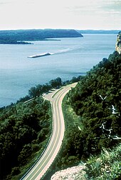
The Great River Road is a collection of state and local roads that follow the course of the Mississippi River through ten states of the United States. They are Minnesota, Wisconsin, Iowa, Illinois, Missouri, Kentucky, Tennessee, Arkansas, Mississippi and Louisiana. It formerly extended north into Canada, serving the provinces of Ontario and Manitoba. The road is designated as both a National Scenic Byway and an All-American Road in several states along the route.
The Red River is a major river in the Southern United States. It was named for its reddish water color from passing through red-bed country in its watershed. It also is known as the Red River of the South to distinguish it from the Red River of the North, which flows between Minnesota and North Dakota into the Canadian province of Manitoba. Although once a tributary of the Mississippi River, the Red River now is a tributary of the Atchafalaya River, a distributary of the Mississippi that flows separately into the Gulf of Mexico. This confluence is connected to the Mississippi River by the Old River Control Structure.
The Atchafalaya River is a 137-mile-long (220 km) distributary of the Mississippi River and Red River in south central Louisiana in the United States. It flows south, just west of the Mississippi River, and is the fifth largest river in North America, by discharge. The name Atchafalaya comes from Choctaw for 'long river', from hachcha, 'river', and falaya, 'long'.
The Mississippi River Delta is the confluence of the Mississippi River with the Gulf of Mexico in Louisiana, southeastern United States. The river delta is a three-million-acre area of land that stretches from Vermilion Bay on the west, to the Chandeleur Islands in the east, on Louisiana's southeastern coast. It is part of the Gulf of Mexico and the Louisiana coastal plain, one of the largest areas of coastal wetlands in the United States. The Mississippi River Delta is the 7th largest river delta on Earth (USGS) and is an important coastal region for the United States, containing more than 2.7 million acres of coastal wetlands and 37% of the estuarine marsh in the conterminous U.S. The coastal area is the nation's largest drainage basin and drains about 41% of the contiguous United States into the Gulf of Mexico at an average rate of 470,000 cubic feet per second.
The Old River Control Structure is a floodgate system in a branch of the Mississippi River in central Louisiana. It regulates the flow of water from the Mississippi into the Atchafalaya River, thereby preventing the Mississippi River from changing course. Completed in 1963, the complex was built by the U.S. Army Corps of Engineers in a side channel of the Mississippi known as "Old River", between the Mississippi's current channel and the Atchafalaya Basin, a former channel of the Mississippi.
The United States Army Corps of Engineers Mississippi Valley Division (MVD) is responsible for the Corps water resources programs within 370,000-square-miles of the Mississippi River Valley, as well as the watershed portions of the Red River of the North that are within the United States. It encompasses the entire Mississippi River from Lake Itasca, Minnesota, to the Gulf of Mexico. It excludes the watersheds of the Missouri River and Ohio River, and portions of the Arkansas River and the Red River of the South. The division includes all or parts of 13 states: Arkansas, Illinois, Iowa, Kentucky, Louisiana, Michigan, Minnesota, Mississippi, Missouri, North Dakota, Tennessee, Wisconsin, and South Dakota.
The Industrial Canal is a 5.5-mile (8.9 km) waterway in New Orleans, Louisiana, United States. The waterway's proper name, as used by the U.S. Army Corps of Engineers and on NOAA nautical charts, is Inner Harbor Navigation Canal (IHNC). The more common "Industrial Canal" name is used locally, both by commercial mariners and by landside residents.
The Atchafalaya Basin, or Atchafalaya Swamp, is the largest wetland and swamp in the United States. Located in south central Louisiana, it is a combination of wetlands and river delta area where the Atchafalaya River and the Gulf of Mexico converge. The river stretches from near Simmesport in the north through parts of eight parishes to the Morgan City southern area.
The Mississippi River System, also referred to as the Western Rivers, is a mostly riverine network of the United States which includes the Mississippi River and connecting waterways. The Mississippi River is the largest drainage basin in the United States. In the United States, the Mississippi drains about 41% of the country's rivers.
The Lower Mississippi River is the portion of the Mississippi River downstream of Cairo, Illinois. From the confluence of the Ohio River and the Middle Mississippi River at Cairo, the Lower flows just under 1000 miles (1600 km) to the Gulf of Mexico. It is the most heavily travelled component of the Mississippi River System.
The Upper Mississippi River is the portion of the Mississippi River upstream of St. Louis, Missouri, United States, a city at the confluence of its main tributary, the Missouri River. Historically, it may refer to the area above the Arkansas Post, above the confluence of Ohio River, or above Cape Girardeau.
The Morganza Spillway or Morganza Control Structure is a flood-control structure in the U.S. state of Louisiana. It is located along the western bank of the Lower Mississippi River at river mile 280, near Morganza in Pointe Coupee Parish. The spillway stands between the Mississippi and the Morganza Floodway, which leads to the Atchafalaya Basin and the Atchafalaya River in south-central Louisiana. Its purpose is to divert water from the Mississippi River during major flood events by flooding the Atchafalaya Basin, including the Atchafalaya River and the Atchafalaya Swamp. The spillway and adjacent levees also help prevent the Mississippi from changing its present course through the major port cities of Baton Rouge and New Orleans to a new course down the Atchafalaya River to the Gulf of Mexico. The Morganza Spillway, operated by the U.S. Army Corps of Engineers, was opened during the 1973 and 2011 Mississippi River floods.
The Flood Control Act of 1965, Title II of Pub. L.89–298, was enacted on October 27, 1965, by the 89th Congress and authorized the United States Army Corps of Engineers to design and construct numerous flood control projects including the Lake Pontchartrain and Vicinity, Louisiana Hurricane Protection Project in the New Orleans region of south Louisiana.
The Water Resources Development Act of 1999, Pub. L.106–53 (text)(PDF), was enacted by Congress of the United States on August 17, 1999. Most of the provisions of WRDA 1999 are administered by the United States Army Corps of Engineers.
The Water Resources Development Act of 2000, Pub. L.106–541 (text)(PDF), was enacted by Congress of the United States on December 11, 2000. Most of the provisions of WRDA 2000 are administered by the United States Army Corps of Engineers.
Wax Lake was a lake in St. Mary Parish, Louisiana that was converted into an outlet channel, the Wax Lake outlet, to divert water from the Atchafalaya River to the Gulf of Mexico.
The Sherburne Complex(Sherburn is a joint land management venture of the U.S. Fish and Wildlife Service, the Louisiana Department of Wildlife and Fisheries, and the U.S. Army Corps of Engineers that began in 1983. The area consists of 43,637 acres, and is managed by the Louisiana Department of Wildlife and Fisheries. The complex is located in the Morganza Flood way system of the Atchafalaya Basin about 30 miles west of Baton Rouge, Louisiana and actually extends a little south of the I-10 Atchafalaya Basin Bridge at Whiskey Bay, Louisiana. The bridge crosses the Whiskey Bay Pilot Channel. Located on the graveled
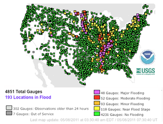
Major floods along the Mississippi River in April and May 2011 were among the largest and most damaging recorded along the U.S. waterway in the past century, comparable in extent to the Great Mississippi Flood of 1927 and Great Flood of 1993. In April 2011, two large storm systems deposited record levels of rainfall on the Mississippi River drainage basin. When that additional water combined with the springtime snowmelt, the river and many of its tributaries began to swell to record levels by the beginning of May. Flooding occurred in Illinois, Missouri, Kentucky, Tennessee, Arkansas, Mississippi, and Louisiana.
The Mississippi flood of 1973 occurred between March and May 1973 on the lower Mississippi River. The flooding was the third most severe along the U.S.'s Mississippi River during the 20th century.
References
↑ James L. Shaffer and John T. Tigges. The Mississippi River: Father of Waters. Chicago, Ill.: Arcadia Pub., 2000.
↑ The Upper Mississippi River Basin: A Portrait of the Father of Waters As Seen by the Upper Mississippi River Comprehensive Basin Study. Chicago, Ill.: Army Corps of Engineers, North Central Division, 1972.
↑ Heilbron, Bertha L. "Father of Waters: Four Centuries of the Mississippi". American Heritage, vol. 2, no. 1 (Autumn 1950): 40–43.
1 2 Median of the 14,610 daily streamflows recorded by the USGS for the period 1967–2006.
↑ Hirschfelder, Arlene B. (2012). The Extraordinary Book of Native American Lists. Paulette Fairbanks Molin. Lanham, MD: Scarecrow Press, Inc. p.260. ISBN978-0-8108-7710-8. OCLC794706782.
↑ Rodriguez, Junius P. (2003). "Jay–Gardoqui Negotiations (1785–1786)". In Rodriguez, Junius P. (ed.). The Louisiana Purchase: A Historical and Geographical Encyclopedia. Santa Barbara, California: ABC-CLIO. ISBN978-1-57607-188-5. Archived from the original on August 16, 2023. Retrieved August 16, 2023– via Google Books.
↑ Schroeder, Walter (2006). "Mississippi River". In Cayton, Andrew R. L.; Sisson, Richard; Zacher, Chris (eds.). The American Midwest: An Interpretive Encyclopedia. Bloomington, Indiana: Indiana University Press. pp.164–165. ISBN9780253003492. Archived from the original on August 16, 2023. Retrieved August 16, 2023– via Google Books.
↑ "Gateway Arch 'Biography' Reveals Complex History Of An American Icon". Weekend Edition Saturday. National Public Radio. May 25, 2013.
↑ 2001 U.S. Army Corps of Engineers Upper Mississippi River Navigation Chart
↑ Middle Mississippi River Regional Corridor: Collaborative Planning Study (July 2007 update). St. Louis, MO: U.S. Army Corps of Engineers, St. Louis District. 2007. p.28.
↑ Frits van der Leeden, Fred L. Troise, David Keith Todd: The Water Encyclopedia, 2nd edition, p. 126, Chelsea, Mich. (Lewis Publishers), 1990, ISBN0-87371-120-3
1 2 McPhee, John (February 23, 1987). "The Control of Nature: Atchafalaya". The New Yorker. Archived from the original on May 13, 2011. Retrieved May 12, 2011. Republished in McPhee, John (1989). The Control of Nature. Farrar, Straus and Giroux. p.272. ISBN0-374-12890-1.
↑ Angert, Joe and Isaac. "Old River Control". The Mighty Mississippi River. Archived from the original on May 15, 2009. Retrieved May 12, 2011. Includes map and pictures.
↑ "Hydrologie du bassin de l'Amazone"(PDF). Grands Bassins Fluviaux, Paris (in French). November 22–24, 1993. Archived(PDF) from the original on October 7, 2016. Retrieved January 11, 2012.
↑ Meade, R. H., and J. A. Moody, 1984, Causes for the decline of suspended-sediment discharge in the Mississippi River system, 1940–2007 Hydrology Processes vol. 24, pp. 35–49.
↑ Knopp, Lisa (2012). What the River carries: Encounters with the Mississippi, Missouri, and Platte. Columbia, Missouri: University of Missouri Press. p.74. ISBN978-0-8262-1974-9.
↑ Mississippi River Water Quality and the Clean Water Act: Progress, Challenges, and Opportunities. National Academies Press, 2008, ISBN 9780309177818, pp. 27–29Archived April 18, 2023, at the Wayback Machine
↑ Costello, Mary Charlotte (2002). Climbing the Mississippi River Bridge by Bridge. Vol.Two: Minnesota. Cambridge, Minnesota: Adventure Publications. ISBN0-9644518-2-4.
↑ "Mississippi River". USGS: Status and trends of the nation's biological resources. Archived from the original on September 27, 2006. Retrieved February 3, 2007.
↑ Nicks, Oran W., ed. (1970). This Island Earth. NASA. p.137.
↑ Richerson, P.J.; Boyd, R.; Bettinger, R.L. (2001). "Was Agriculture Impossible During the Pleistocene but Mandatory during the Holocene? A Climate Change Hypothesis". American Antiquity. 66 (3): 387–411. doi:10.2307/2694241. JSTOR2694241. S2CID163474968.
↑ Pauketat, Timothy R. (1998). "Refiguring the Archaeology of Greater Cahokia". Journal of Archaeological Research. 6 (1): 45–89. doi:10.1023/A:1022839329522. S2CID195219118.
↑ Gilfillan, Joseph A., "Minnesota Geographical Names Derived from the Chippewa Language" in The Geological and Natural History Survey of Minnesota: The Fifteenth Annual Report for the Year 1886 (St. Paul: Pioneer Press Company, 1887)
↑ "Pierre Le Moyne, Sieur d'Iberville" (bio), webpage from The Catholic Encyclopedia, Volume VII, 1910, New York: CathEn-07614bArchived May 15, 2008, at the Wayback Machine .
↑ Roseman, Curtis C., and Elizabeth M. Roseman. Grand Excursions on the Upper Mississippi River: Places, Landscapes, And Regional Identity After 1854. Iowa City: University Of Iowa Press, 2004.
↑ Smith, Thomas Ruys. River of Dreams: Imagining The Mississippi Before Mark Twain. Baton Rouge: Louisiana State University Press, 2007.
↑ Tomblin, Barbara (2016). The Civil War on the Mississippi: Union Sailors, Gunboat Captains, and the Campaign to Control the River. Lexington, Kentucky: University Press of Kentucky. pp.281–290. ISBN978-0-8131-6703-9.
↑ "Mississippi River Basin Receives D+ in First-Ever Report Card" (Press Release). U.S. Army Corps of Engineers. Mississippi Valley Division. October 14, 2015. Retrieved November 7, 2015. US Army Corps of Engineers websiteArchived October 5, 2023, at the Wayback Machine
1 2 3 Matthews, W.J. (1998). Patterns in Freshwater Fish Ecology. Springer. pp.5 and 236. ISBN978-1-4615-4066-3.
↑ Ye, S.; Li, Z.; Liu, J.; Zhang, T.; Xie, S. (2011). "Distribution, Endemism and Conservation Status of Fishes in the Yangtze River Basin, China". Ecosystems Biodiversity. BoD – Books on Demand. pp.41–66. ISBN978-953-307-417-7.
↑ Hobbs, H.H. Jr. (1989). "An Illustrated Checklist of the American Crayfishes (Decapoda, Astacidae, Cambaridae, Parastacidae)". Smithsonian Contributions to Zoology. 480 (480): 1–236. doi:10.5479/si.00810282.480.
Ambrose, Stephen. The Mississippi and the Making of a Nation: From the Louisiana Purchase to Today (National Geographical Society, 2002) heavily illustrated
Botkin, Benjamin Albert. A Treasury of Mississippi River folklore: stories, ballads & traditions of the mid-American river country (1984).
Carlander, Harriet Bell. A history of fish and fishing in the upper Mississippi River (PhD Diss. Iowa State College, 1954) onlineArchived April 30, 2015, at the Wayback Machine (PDF)
Daniel, Pete. Deep'n as it come: The 1927 Mississippi River flood (University of Arkansas Press, 1977)
Fremling, Calvin R. Immortal river: the Upper Mississippi in ancient and modern times (U. of Wisconsin Press, 2005), popular history
Knox, James C. The Mississippi River System. In Avijit Gupta, ed., Large Rivers: Geomorphology and Management. 2nd Ed. Hoboken, N.J.: Wiley-Blackwell, pp. 205–252. ISBN 9781119412601
Milner, George R. "The late prehistoric Cahokia cultural system of the Mississippi River valley: Foundations, florescence, and fragmentation." Journal of World Prehistory (1990) 4#1 pp: 1–43.
Morris, Christopher. The Big Muddy: An Environmental History of the Mississippi and Its Peoples From Hernando de Soto to Hurricane Katrina (Oxford University Press; 2012) 300 pages; links drought, disease, and flooding to the impact of centuries of increasingly intense human manipulation of the river.
This page is based on this Wikipedia article Text is available under the CC BY-SA 4.0 license; additional terms may apply. Images, videos and audio are available under their respective licenses.


