Ferryville, Wisconsin | |
---|---|
Coordinates: 43°20′30″N91°5′2″W / 43.34167°N 91.08389°W | |
Country | United States |
State | Wisconsin |
County | Crawford |
Area | |
• Total | 1.99 sq mi (5.15 km2) |
• Land | 1.97 sq mi (5.10 km2) |
• Water | 0.02 sq mi (0.05 km2) |
Elevation | 646 ft (197 m) |
Population | |
• Total | 176 |
• Estimate (2019) [4] | 176 |
• Density | 89.48/sq mi (34.54/km2) |
Time zone | UTC-6 (Central (CST)) |
• Summer (DST) | UTC-5 (CDT) |
Area code | 608 |
FIPS code | 55-25725 [5] |
GNIS feature ID | 1564924 [2] |
Website | www |
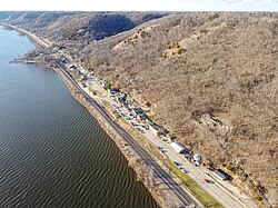
Ferryville is a village in Crawford County, Wisconsin, United States. The population was 176 at the 2010 census. It is located on Wisconsin Highway 35 along the Great River Road.
Ferryville is located at 43°20′30″N91°5′2″W / 43.34167°N 91.08389°W (43.341550, -91.083882). [6]
According to the United States Census Bureau, the village has a total area of 1.99 square miles (5.15 km2), of which, 1.97 square miles (5.10 km2) is land and 0.02 square miles (0.05 km2) is water. [7]
Census | Pop. | Note | %± |
---|---|---|---|
1920 | 203 | — | |
1930 | 266 | 31.0% | |
1940 | 306 | 15.0% | |
1950 | 216 | −29.4% | |
1960 | 194 | −10.2% | |
1970 | 183 | −5.7% | |
1980 | 227 | 24.0% | |
1990 | 154 | −32.2% | |
2000 | 174 | 13.0% | |
2010 | 176 | 1.1% | |
2019 (est.) | 176 | [4] | 0.0% |
U.S. Decennial Census [8] |
As of the census [3] of 2010, there were 176 people, 94 households, and 59 families living in the village. The population density was 89.3 inhabitants per square mile (34.5/km2). There were 165 housing units at an average density of 83.8 per square mile (32.4/km2). The racial makeup of the village was 98.3% White, 0.6% from other races, and 1.1% from two or more races. Hispanic or Latino people of any race were 2.3% of the population.
There were 94 households, of which 16.0% had children under the age of 18 living with them, 48.9% were married couples living together, 12.8% had a female householder with no husband present, 1.1% had a male householder with no wife present, and 37.2% were non-families. 33.0% of all households were made up of individuals, and 16% had someone living alone who was 65 years of age or older. The average household size was 1.87 and the average family size was 2.32.
The median age in the village was 60.5 years. 13.6% of residents were under the age of 18; 3.3% were between the ages of 18 and 24; 7.9% were from 25 to 44; 38.1% were from 45 to 64; and 36.9% were 65 years of age or older. The gender makeup of the village was 47.2% male and 52.8% female.
As of the census [5] of 2000, there were 174 people, 93 households, and 55 families living in the village. The population density was 70.5 people per square mile (27.2/km2). There were 149 housing units at an average density of 60.4 per square mile (23.3/km2). The racial makeup of the village was 98.85% White, and 1.15% from two or more races.
There were 93 households, out of which 15.1% had children under the age of 18 living with them, 53.8% were married couples living together, 4.3% had a female householder with no husband present, and 39.8% were non-families. 39.8% of all households were made up of individuals, and 23.7% had someone living alone who was 65 years of age or older. The average household size was 1.87 and the average family size was 2.45.
In the village, the population was spread out, with 12.6% under the age of 18, 4.6% from 18 to 24, 17.2% from 25 to 44, 43.7% from 45 to 64, and 21.8% who were 65 years of age or older. The median age was 54 years. For every 100 females, there were 104.7 males. For every 100 females age 18 and over, there were 102.7 males.
The median income for a household in the village was $33,958, and the median income for a family was $45,833. Males had a median income of $28,125 versus $20,357 for females. The per capita income for the village was $20,602. About 3.4% of families and 4.5% of the population were below the poverty line, including none of those under the age of eighteen and 11.9% of those 65 or over.
The De Soto Area Schools serves Ferryville. [9]
Bus service towards La Crosse and Prairie du Chien is provided three times daily per direction by Scenic Mississippi Regional Transit. [10]
Fall River is a village in Columbia County, Wisconsin, United States, along the North Fork of the Crawfish River. The population was 1,712 at the 2010 census. It is part of the Madison Metropolitan Statistical Area.
Rio is a village in Columbia County, Wisconsin, United States. The population was 1,133 at the 2022 United States Census. It is part of the Madison Metropolitan Statistical Area. The village rests primarily in the town of Otsego. The Village of Rio calls itself "Camper Country USA" due to several campgrounds located near the village. Rio is halfway between Columbus and Portage on Highway 16.
Neosho is a village in Dodge County, Wisconsin, United States. The population was 574 at the 2010 census.
Taylor is a village in Jackson County, Wisconsin, United States, along the Trempealeau River. The population was 484 at the 2020 census.
Glen Flora is a village in Rusk County, Wisconsin, United States. The population was 92 at the 2010 census. Originally named Miller's Siding for Frank Miller, who built the first saw mill in the area in the 1880s, the village received its current name in December 1887 when the post office was established. The village is surrounded by the town of True.
Loganville is a village in Sauk County, Wisconsin, United States. The population was 300 at the 2010 census. The village was named for Chauncey P. Logan who built the first house in 1853.
Eland is a village in Shawano County, Wisconsin, in the United States. The population was 202 at the 2010 census.
Adell is a village in Sheboygan County, Wisconsin, United States. The population was 498 at the 2020 census. It is included in the Sheboygan, Wisconsin Metropolitan Statistical Area.
Glenbeulah is a village in Sheboygan County, Wisconsin, United States. The population was 463 at the 2010 census. It is included in the Sheboygan, Wisconsin Metropolitan Statistical Area. Glenbeulah is situated on the Mullet River.
Ontario is a village in Vernon County, Wisconsin, United States. The population was 554 at the 2010 census.
Big Falls is a village in Waupaca County, Wisconsin, United States. The population was 61 at the 2010 census.
Viola is a village in Richland (mostly) and Vernon counties in the U.S. state of Wisconsin. The population was 699 at the 2010 census. Of this, 477 were in Richland County, and 222 were in Vernon County.
Kingston is a village in Green Lake County, Wisconsin, United States. The population was 326 at the 2010 census. The village is located within the Town of Kingston. The unincorporated community of Dalton, Wisconsin is near Kingston.
Theresa is a village in Dodge County, Wisconsin, United States. The population was 1,262 at the 2010 census. The village is within the Town of Theresa.
Eden is a village in Fond du Lac County, Wisconsin, United States. The population was 884 at the 2020 census. The village is located within the Town of Eden.
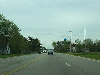
Arena is a village in Iowa County, Wisconsin, United States. The population was 834 at the 2010 census. The village is located within the Town of Arena. It is part of the Madison Metropolitan Statistical Area.
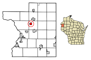
Milltown is a village in Polk County, Wisconsin, United States. The population was 917 at the 2010 census. The village is located within the Town of Milltown.
Ironton is a village in Sauk County, Wisconsin, United States, along the Little Baraboo River. The population was 253 at the 2010 census. The village is located within the Town of Ironton.
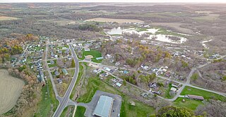
La Valle is a village in Sauk County, Wisconsin, United States, along the Baraboo River. The population was 367 at the 2010 census. The village is located within the Town of La Valle.
Merrimac is a village in Sauk County, Wisconsin, United States, northwest of Madison. The population was 420 at the 2010 census. The village is located within the Town of Merrimac.