Clayton, Crawford County, Wisconsin

Last updated

Clayton, Wisconsin
Town of Clayton, Wisconsin.jpg
Clayton town hall. US-61 runs by.
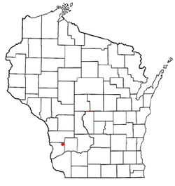
WIMap-doton-Clayton.png
Location of Clayton, Wisconsin
Coordinates: 43°22′10″N90°44′44″W / 43.36944°N 90.74556°W / 43.36944; -90.74556
Country Flag of the United States.svg  United States
State Flag of Wisconsin.svg  Wisconsin
County Crawford
Area
  Total69.2 sq mi (179.3 km2)
  Land69.2 sq mi (179.3 km2)
  Water0.0 sq mi (0.0 km2)
Elevation
[1]
1,115 ft (340 m)
Population
 (2000)
  Total956
  Density13.8/sq mi (5.3/km2)
Time zone UTC-6 (Central (CST))
  Summer (DST) UTC-5 (CDT)
Area code 608
FIPS code 55-15075 [2]
GNIS feature ID1582966 [1]

Clayton is a town in Crawford County, Wisconsin, United States. The population was 956 at the 2000 census. The unincorporated communities of Montgomeryville, North Clayton, and Yankeetown [3] are located in the town.

Contents

Geography

According to the United States Census Bureau, the town has a total area of 69.2 square miles (179.3 km2), all of it land.

Demographics

As of the census [2] of 2000, there were 956 people, 364 households, and 279 families residing in the town. The population density was 13.8 people per square mile (5.3/km2). There were 524 housing units at an average density of 7.6 per square mile (2.9/km2). The racial makeup of the town was 96.03% White, 0.42% African American, 0.42% Native American, 0.42% Asian, 1.57% from other races, and 1.15% from two or more races. Hispanic or Latino of any race were 2.51% of the population.

There were 364 households, out of which 32.1% had children under the age of 18 living with them, 62.6% were married couples living together, 9.3% had a female householder with no husband present, and 23.1% were non-families. 20.3% of all households were made up of individuals, and 6.9% had someone living alone who was 65 years of age or older. The average household size was 2.63 and the average family size was 2.99.

In the town, the population was spread out, with 26.3% under the age of 18, 6.2% from 18 to 24, 26.0% from 25 to 44, 28.6% from 45 to 64, and 13.0% who were 65 years of age or older. The median age was 40 years. For every 100 females, there were 105.6 males. For every 100 females age 18 and over, there were 106.7 males.

The median income for a household in the town was $30,433, and the median income for a family was $31,875. Males had a median income of $23,182 versus $20,221 for females. The per capita income for the town was $13,786. About 13.1% of families and 18.1% of the population were below the poverty line, including 26.2% of those under age 18 and 12.3% of those age 65 or over.

Related Research Articles

<span class="mw-page-title-main">Mosses, Alabama</span> Town in Alabama, United States

Mosses is a town in Lowndes County, Alabama, United States. At the 2010 census the population was 1,029, down from 1,101 in 2000. It is part of the Montgomery Metropolitan Statistical Area. It incorporated in 1979.

<span class="mw-page-title-main">Bronson, Florida</span> Town in Florida, United States

Bronson is a town and the county seat of Levy County, Florida, United States. The population was 1,140 at the 2020 census.

<span class="mw-page-title-main">Yankeetown, Florida</span> Town in the state of Florida, United States

Yankeetown is a town in Levy County, Florida, United States. Its located in North Florida along the Gulf of Mexico. The Town of Yankeetown is part of both the Big Bend Coast and the Nature Coast. In the 2020 census, the population was 588.

<span class="mw-page-title-main">Mount Sterling, Illinois</span> City in Illinois, United States

Mount Sterling is a city in and the county seat of Brown County, Illinois, United States. The population was 2,006 at the 2020 census.

<span class="mw-page-title-main">Walton, Indiana</span> Town in Indiana, United States

Walton is a town in Tipton Township, Cass County, Indiana, United States. The population was 1,049 at the 2010 census.

<span class="mw-page-title-main">Clayton, Iowa</span> City in Iowa, United States

Clayton is a city in Clayton County, Iowa, United States. The population was 45 at the 2020 census, down from 55 in 2000. Clayton is located directly on the Mississippi River and is only accessible via a very steep road.

<span class="mw-page-title-main">Edgewood, Iowa</span> City in Iowa, United States

Edgewood is a city in Clayton and Delaware counties in the U.S. state of Iowa. Highway 3, which runs through the center of town, is the dividing line between the two counties. The Edgewood post office was established in 1852 on the Clayton side of the town. Edgewood was formally incorporated in 1892, although it had a functioning council for some time before that date. The population was 909 at the time of the 2020 census, down from 923 in 2000.

<span class="mw-page-title-main">Garnavillo, Iowa</span> City in Iowa, United States

Garnavillo is a city in Clayton County, Iowa, United States. The population was 763 at the time of the 2020 census, up from 754 in 2000.

<span class="mw-page-title-main">Mount Vernon, Maine</span> Town in the state of Maine, United States

Mount Vernon is a town in Kennebec County, Maine, United States. The population was 1,721 at the 2020 census. Mount Vernon is included in the Augusta, Maine micropolitan New England City and Town Area. A popular recreation spot in central Maine, the northern area of Mount Vernon is part of the Belgrade Lakes Region, while the southern area is part of the Winthrop Lakes Region.

<span class="mw-page-title-main">Hartford, Maine</span> Town in the state of Maine, United States

Hartford is a town in Oxford County, Maine, United States. Hartford is included in the Lewiston-Auburn, Maine metropolitan New England City and Town Area. The population was 1,203 at the 2020 census.

<span class="mw-page-title-main">Harrington, Maine</span> Town in the state of Maine, United States

Harrington is a town in Washington County, Maine, United States. The population was 962 at the 2020 census. Harrington is an old seafaring and shipbuilding village.

<span class="mw-page-title-main">Henning, Minnesota</span> City in Minnesota, United States

Henning is a city in Otter Tail County, Minnesota, United States. The population was 854 at the 2020 census.

<span class="mw-page-title-main">Delaware, New York</span> Town in Sullivan County, New York, US

Delaware is a town in Sullivan County, New York, United States. The population was 2,203 at the 2020 census.

<span class="mw-page-title-main">Benton, New York</span> Town in New York, United States

Benton is a town in Yates County, New York, United States. The population was 2,836 at the 2010 census. The town is named after an early resident, Levi Benton (1746-1820)

<span class="mw-page-title-main">Clover, Wisconsin</span> Town in Wisconsin, United States

Clover is a town in Bayfield County, Wisconsin, United States. The population was 223 at the 2010 census. The unincorporated communities of Bark Point and Herbster are located in the town.

Whitewater is a town in Walworth County, Wisconsin, United States. The population was 1,433 at the 2020 census.

<span class="mw-page-title-main">Matteson, Wisconsin</span> Town in Wisconsin, United States

Matteson is a town in Waupaca County, Wisconsin, United States. The population was 956 at the 2000 census. The former unincorporated community of Hunting was located partially in the town.

<span class="mw-page-title-main">Clayton, Kansas</span> City in Decatur and Norton Counties of Kansas

Clayton is a city in Decatur and Norton counties in the U.S. state of Kansas. As of the 2020 census, the population of the city was 44.

<span class="mw-page-title-main">Theresa (town), Wisconsin</span> Town in Wisconsin, United States

Theresa is a town in Dodge County, Wisconsin, United States. As of the census in 2000, the town population was 1,080. The Village of Theresa is located within the town. The unincorporated community of Theresa Station is located in the town. The unincorporated community of Hochheim is also located partially in the town.

<span class="mw-page-title-main">La Valle (town), Wisconsin</span>

The Town of La Valle is located in Sauk County, Wisconsin, United States. La Valle is a name derived from French meaning "the valley". The population was 1,203 at the 2000 census. The Village of La Valle is located within the town.

References

  1. 1 2 "US Board on Geographic Names". United States Geological Survey. October 25, 2007. Retrieved January 31, 2008.
  2. 1 2 "U.S. Census website". United States Census Bureau . Retrieved January 31, 2008.
  3. "Yankeetown, Wisconsin". Geographic Names Information System . United States Geological Survey, United States Department of the Interior.