Zion is a city in Lake County, Illinois, United States. The population was 22,866 at the 2000 census, and had grown to 24,413 as of 2010.

Winnebago County is a county in the U.S. state of Wisconsin. As of the 2010 census, the population was 166,994. Its county seat is Oshkosh. It was named for the historic Winnebago people, a federally recognized Native American tribe now known as the Ho-Chunk Nation. Chief Oshkosh was a leader in the area.

Vernon County is a county in the U.S. state of Wisconsin. As of the 2010 census, the population was 29,773. Its county seat is Viroqua.

Richland County is a county in the U.S. state of Wisconsin. As of the 2010 census, the population was 18,021. Its county seat is Richland Center. The county was created from the Wisconsin Territory in 1842 and organized in 1850. It is named for the high quality of its soil. Some rural areas in the county have their power provided by the Richland Electric Cooperative.
Iowa County is a county in the U.S. state of Wisconsin. As of the 2010 census, the population was 23,687. Its county seat and largest city is Dodgeville. When created, it was part of the Michigan Territory.

Grant County is a county located in the U.S. state of Wisconsin. As of the 2010 census, the population was 51,208. Its county seat is Lancaster.

Mount Zion is a city in Carroll County, Georgia, United States. The population was 1,696 at the 2010 census.
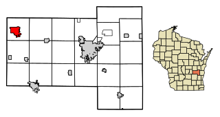
Ripon [ɹɪpɘn] is a city in Fond du Lac County, Wisconsin, United States. The population was 7,733 at the 2010 census. The city is surrounded by the Town of Ripon.

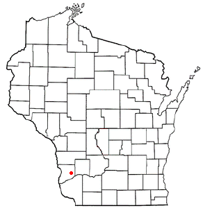
Rolling Ground is a small unincorporated community in the town of Clayton in Crawford County, Wisconsin, United States. Rolling Ground is a part of the Great Rivers Snowmobile Tour.
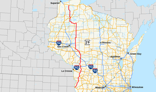
State Trunk Highway 27 is a state highway in the U.S. state of Wisconsin. The highway spans a length of 294 miles (473 km) and is generally two-lane local road with the exception of urban multilane arterials within some cities. Earlier routing of the highway had it reaching Superior along the present US 53 and Fennimore along the present US 61 and following I-94 between Black River Falls and Osseo.

Gill Township is one of nine townships in Sullivan County, Indiana, United States. As of the 2010 census, its population was 871 and it contained 416 housing units.
Blue River Township is one of twelve townships in Harrison County, Indiana, United States. As of the 2010 census, its population was 2,064 and it contained 889 housing units.
Hawlings River is a 12.9-mile-long (20.8 km) tributary of the Patuxent River in Montgomery County, Maryland. The watershed covers an area of about 28 square miles (73 km2). The headwaters of the river originate in the area north of Laytonsville, and the river flows southeast, entering the Patuxent about 1.5 miles (2.4 km) below the Triadelphia Reservoir. Portions of Hawlings River flow through Rachel Carson Conservation Park and Hawlings River Stream Valley Park. Tributaries of the Hawlings River include Mount Zion Tributary, Reddy Branch, Olney Mill Tributary, Gregg Tributary, and James Creek. The river and its tributaries total about 98 miles (158 km) of streams.
Seneca is an unincorporated community in the town of Seneca, Crawford County, Wisconsin, United States. Seneca is on Wisconsin Highway 27 4 miles (6.4 km) south-southwest of Mount Sterling. Seneca has a post office with ZIP code 54654.
Plugtown is an unincorporated community in the town of Scott, Crawford County, Wisconsin, United States. Plugtown is along U.S. Route 61 and Richland Creek 6.5 miles (10.5 km) north-northwest of Boscobel.
Towerville is an unincorporated community in the town of Utica, Crawford County, Wisconsin, United States. Towerville is along County Highway B and Tainter Creek 6 miles (9.7 km) west of Soldiers Grove.
Mount Zion is a former settlement in Nevada County, California. Mount Zion is located 1.5 miles (2.4 km) east-southeast of Snow Tent. It still appeared on maps as of 1873.
Boydtown is an unincorporated community in the towns of Marietta and Wauzeka, Crawford County, Wisconsin, United States. Boydtown is on Wisconsin Highway 60 and the north bank of the Wisconsin River 4.5 miles (7.2 km) east-northeast of the village of Wauzeka. The community was named by and for Robert Boyd, who laid out the community in 1844 with the expectation of a railroad being built through the area.