Eastman, Wisconsin | |
---|---|
Eastman post office | |
Location of Eastman in Crawford County, Wisconsin. | |
Coordinates: 43°9′28″N90°59′50″W / 43.15778°N 90.99722°W Coordinates: 43°9′28″N90°59′50″W / 43.15778°N 90.99722°W | |
Country | United States |
State | Wisconsin |
County | Crawford |
Area | |
• Total | 3.61 sq mi (9.36 km2) |
• Land | 3.61 sq mi (9.35 km2) |
• Water | 0.00 sq mi (0.00 km2) |
Elevation | 1,145 ft (349 m) |
Population | |
• Total | 428 |
• Estimate (2019) [4] | 403 |
• Density | 111.57/sq mi (43.08/km2) |
Time zone | UTC-6 (Central (CST)) |
• Summer (DST) | UTC-5 (CDT) |
Area code(s) | 608 |
FIPS code | 55-21925 [5] |
GNIS feature ID | 1564390 [2] |
Eastman is a village in Crawford County, Wisconsin, United States. The population was 428 at the 2010 census. The village is located within the Town of Eastman.
Eastman is located at 43°9′49″N91°1′9″W / 43.16361°N 91.01917°W (43.163664, -91.019442). [6]
According to the United States Census Bureau, the village has a total area of 3.61 square miles (9.35 km2), all of it land. [7]
Historical population | |||
---|---|---|---|
Census | Pop. | %± | |
1910 | 233 | — | |
1920 | 286 | 22.7% | |
1930 | 271 | −5.2% | |
1940 | 348 | 28.4% | |
1950 | 359 | 3.2% | |
1960 | 348 | −3.1% | |
1970 | 319 | −8.3% | |
1980 | 371 | 16.3% | |
1990 | 369 | −0.5% | |
2000 | 437 | 18.4% | |
2010 | 428 | −2.1% | |
2019 (est.) | 403 | [4] | −5.8% |
U.S. Decennial Census [8] |
As of the census [3] of 2010, there were 428 people, 168 households, and 117 families living in the village. The population density was 118.6 inhabitants per square mile (45.8/km2). There were 179 housing units at an average density of 49.6 per square mile (19.2/km2). The racial makeup of the village was 98.8% White and 1.2% from two or more races.
There were 168 households, of which 32.7% had children under the age of 18 living with them, 58.3% were married couples living together, 8.9% had a female householder with no husband present, 2.4% had a male householder with no wife present, and 30.4% were non-families. 25.6% of all households were made up of individuals, and 11.9% had someone living alone who was 65 years of age or older. The average household size was 2.55 and the average family size was 3.13.
The median age in the village was 37.8 years. 25.9% of residents were under the age of 18; 9.8% were between the ages of 18 and 24; 23.3% were from 25 to 44; 27.2% were from 45 to 64; and 13.6% were 65 years of age or older. The gender makeup of the village was 51.2% male and 48.8% female.
As of the census [5] of 2000, there were 437 people, 163 households, and 109 families living in the village. The population density was 122.2 people per square mile (47.1/km2). There were 170 housing units at an average density of 47.5 per square mile (18.3/km2). The racial makeup of the village was 97.25% White, 0.23% Native American, 0.23% Asian, and 2.29% from two or more races. 1.83% of the population were Hispanic or Latino of any race.
There were 163 households, out of which 37.4% had children under the age of 18 living with them, 60.7% were married couples living together, 0.6% had a female householder with no husband present, and 33.1% were non-families. 30.7% of all households were made up of individuals, and 16.6% had someone living alone who was 65 years of age or older. The average household size was 2.68 and the average family size was 3.43.
In the village, the population was spread out, with 31.8% under the age of 18, 8.0% from 18 to 24, 26.5% from 25 to 44, 19.7% from 45 to 64, and 14.0% who were 65 years of age or older. The median age was 34 years. For every 100 females, there were 96.8 males. For every 100 females age 18 and over, there were 98.7 males.
The median income for a household in the village was $32,321, and the median income for a family was $41,250. Males had a median income of $29,583 versus $21,250 for females. The per capita income for the village was $12,922. About 5.7% of families and 10.7% of the population were below the poverty line, including 8.8% of those under age 18 and 20.6% of those age 65 or over.
Junction City is a city in Union County, Arkansas, United States, and is the twin city of neighboring Junction City, Louisiana. The population was 581 at the 2010 census.
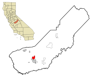
Madera Acres is a census-designated place (CDP) in Madera County, California, United States. It is part of the Madera–Chowchilla Metropolitan Statistical Area. The population was 9,163 at the 2010 census, up from 7,741 at the 2000 census.
Basalt is a city in Bingham County, Idaho, United States. The population was 394 at the 2010 census.
New Middletown is a town in Webster Township, Harrison County, Indiana, United States. The population was 93 at the 2010 census.
Schleswig is a city in Crawford County, Iowa, United States. The population was 882 at the 2010 census.
Cushing is a town in Knox County, Maine, United States. The population was 1,534 at the 2010 census. A favorite of artists for its unspoiled natural setting, Cushing includes the villages of North Cushing, Cushing, South Cushing, and Pleasant Point.
Unionville is a village in Tuscola County in the U.S. state of Michigan. The population was 508 at the 2010 census. The village is located in the northwestern corner of Columbia Township.
Myrtle is a city in Freeborn County, Minnesota, United States. The population was 48 at the 2010 census.
Schell City is a city in Vernon County, Missouri, United States. The population was 249 at the 2010 census.
Redings Mill is a village in Newton County, Missouri, United States. The population was 151 at the 2010 census. It is part of the Joplin, Missouri Metropolitan Statistical Area.
Meridian is a village in Cayuga County, New York, United States. The population was 309 at the 2010 census. Meridian is near the north town line of the town of Cato and is west of Syracuse.
Brice is a village in Franklin County, Ohio, United States, on the southeast side of the Columbus metropolitan area. The population was 114 at the 2010 census. The village theme is "An Early American Village."
New Johnsonville is a city in Humphreys County, Tennessee, United States. The population was 1,951 at the 2010 census.
Friesland is a village in Columbia County, Wisconsin, United States. The population was 356 at the 2010 census. It is part of the Madison Metropolitan Statistical Area.
Blue River is a village in Grant County, Wisconsin, United States. The population was 434 at the 2010 census.
Avoca is a village in Iowa County, Wisconsin, United States. The population was 637 at the 2010 census. It is part of the Madison Metropolitan Statistical Area. It is named after Avoca in Ireland.
Yuba is a village in Richland County, Wisconsin, United States. The population was 74 at the 2010 census. Yuba is 11 miles southwest of Hillsboro and 17 miles north of Richland Center. County Hwy C runs through the village.
Eastman is a town in Crawford County, Wisconsin, United States. The population was 790 at the 2000 census. The Village of Eastman is located within the town. The unincorporated community of Charme is also located in the town.
Wauzeka is a village in Crawford County, Wisconsin, United States. The population was 728 at the 2010 census. The village is located within the Town of Wauzeka.
Oakdale is a village in Monroe County, Wisconsin, United States. The population was 402 at the 2010 census. The village is located within the Town of Oakdale.