The Mississippi River is the primary river of the largest drainage basin in the United States. From its traditional source of Lake Itasca in northern Minnesota, it flows generally south for 2,340 miles (3,766 km) to the Mississippi River Delta in the Gulf of Mexico. With its many tributaries, the Mississippi's watershed drains all or parts of 32 U.S. states and two Canadian provinces between the Rocky and Appalachian mountains. The river either borders or passes through the states of Minnesota, Wisconsin, Iowa, Illinois, Missouri, Kentucky, Tennessee, Arkansas, Mississippi, and Louisiana. The main stem is entirely within the United States; the total drainage basin is 1,151,000 sq mi (2,980,000 km2), of which only about one percent is in Canada. The Mississippi ranks as the world's tenth-largest river by discharge flow, and the largest in North America.

The Great River Road is a collection of state and local roads that follow the course of the Mississippi River through ten states of the United States. They are Minnesota, Wisconsin, Iowa, Illinois, Missouri, Kentucky, Tennessee, Arkansas, Mississippi and Louisiana. It formerly extended north into Canada, serving the provinces of Ontario and Manitoba. The road is designated as both a National Scenic Byway and an All-American Road in several states along the route.

Interstate 55 (I-55) is a major Interstate Highway in the central United States. As with most primary Interstates that end in a five, it is a major cross-country, north–south route, connecting the Gulf of Mexico to the Great Lakes. The highway travels from LaPlace, Louisiana, at I-10 to Chicago, Illinois, at U.S. Route 41, at McCormick Place. The major cities that I-55 connects to are New Orleans, Louisiana; Jackson, Mississippi; Memphis, Tennessee; St. Louis, Missouri; and Chicago, Illinois.
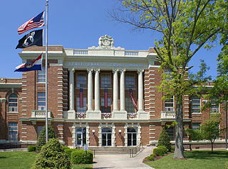
Scott County is a county located in the southeastern portion of the U.S. state of Missouri. As of the 2020 census, the population was 38,059. Its county seat is Benton. The county was organized in 1821 and named for U.S. Representative John Scott, the first federal representative from Missouri. Scott County comprises the Sikeston, MO Micropolitan Statistical Area, which is also included in the Cape Girardeau-Sikeston, MO-IL Combined Statistical Area. The county is home to Scott County Central High School, which has won 18 state championships in boys basketball—the most of any high school in the state.

Cape Girardeau County is located in the southeastern part of the U.S. state of Missouri; its eastern border is formed by the Mississippi River. At the 2020 census, the population was 81,710. The county seat is Jackson, the first city in the US to be named in honor of President Andrew Jackson. Officially organized on October 1, 1812, the county is named after Ensign Sieur Jean Baptiste de Girardot, an official of the French colonial years. The "cape" in the county's name is named after a former promontory rock overlooking the Mississippi River; this feature was demolished during railroad construction. Cape Girardeau County is the hub of the Cape Girardeau–Jackson metropolitan area. Its largest city is Cape Girardeau.

East Cape Girardeau is a village in Alexander County, Illinois, United States. The population was 289 at the 2020 census. It is part of the Cape Girardeau–Jackson, MO-IL Metropolitan Statistical Area.
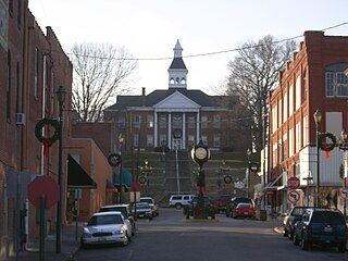
Cape Girardeau is a city in Cape Girardeau and Scott Counties in the U.S. state of Missouri. At the 2020 census, the population was 39,540, making it the 17th-largest in the state. The city is one of two principal cities of the Cape Girardeau, MO-IL Metropolitan Statistical Area, which encompasses Alexander County, Illinois, Bollinger County, Missouri and Cape Girardeau County, Missouri and has a population of 97,517. The sliver of the city located in Scott County is part of the Sikeston Micropolitan Statistical Area, and the entire city forms the core of the Cape Girardeau-Sikeston Combined Statistical Area.

U.S. Route 61 or U.S. Highway 61 (U.S. 61) is a major United States highway that extends 1,400 miles (2,300 km) between New Orleans, Louisiana and the city of Wyoming, Minnesota. The highway generally follows the course of the Mississippi River and is designated the Great River Road for much of its route. As of 2004, the highway's northern terminus in Wyoming, Minnesota, is at an intersection with Interstate 35 (I-35). Until 1991, the highway extended north on what is now Minnesota State Highway 61 through Duluth to the Canada–U.S. border near Grand Portage, then continued to Thunder Bay, Canada, as Ontario Highway 61. Its southern terminus in New Orleans is at an intersection with U.S. Route 90. The route was an important south–north connection in the days before the interstate highway system.

Southern Illinois is a region of the U.S. state of Illinois comprising the southern third of the state, principally south of Interstate 70. Part of downstate Illinois, it is bordered by the two most voluminous rivers in the United States: the Mississippi below its connection with the Missouri River to the west and the Ohio River to the east and south, with the tributary Wabash River, extending the southeastern border. Some areas of Southern Illinois are known historically as Little Egypt.
Southeast Missouri State University is a public university in Cape Girardeau, Missouri. In addition to the main campus, the university has four regional campuses offering full degree programs and a secondary campus housing the Holland College of Arts and Media. The university is accredited by the Higher Learning Commission.

Jo Ann Emerson is an American politician who was the U.S. representative for Missouri's 8th congressional district from 1996 to 2013. The district consists of Southeast and South Central Missouri and includes the Bootheel, the Lead Belt and the Ozarks. Emerson is a member of the Republican Party. On January 22, 2013, Emerson resigned her seat in Congress to become the president and chief executive officer of the National Rural Electric Cooperative Association. She served as CEO until August 2015.

The Congressman William L. Clay Sr. Bridge, formerly known as the Bernard F. Dickmann Bridge and popularly as the Poplar Street Bridge or PSB, completed in 1967, is a 647-foot-long (197 m) deck girder bridge across the Mississippi River between St. Louis, Missouri, and East St. Louis, Illinois. The bridge arrives on the Missouri shore line just south of the Gateway Arch.

Forgottonia, also spelled Forgotonia, is the name given to a 16-county region in Western Illinois in the late 1960s and early 1970s. This geographic region forms the distinctive western bulge of Illinois that is roughly equivalent to "The Tract", the Illinois portion of the Military Tract of 1812, along and west of the Fourth Principal Meridian. Since this wedge-shaped region lies between the Illinois and Mississippi rivers, it has historically been isolated from the eastern portion of Central Illinois.

Norvell William Emerson was an American politician. He served as a member of the United States House of Representatives from Missouri from 1981 until his death from lung cancer in Bethesda, Maryland in 1996. He was succeeded in the House by his widow, Jo Ann Emerson. Emerson was a Republican.
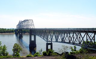
The Chester Bridge is a continuous truss bridge connecting Missouri's Route 51 with Illinois Route 150 across the Mississippi River between Perryville, Missouri and Chester, Illinois. It is the only motor-traffic bridge spanning the Mississippi River between St. Louis and Cape Girardeau, Missouri.

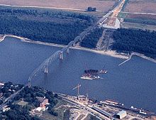
The Cape Girardeau Bridge was a continuous through truss bridge connecting Missouri's Route 34 with Illinois Route 146 across the Mississippi River between Cape Girardeau, Missouri, and East Cape Girardeau, Illinois. It was replaced in 2003 with the Bill Emerson Memorial Bridge.

Interstate 66 (I-66) is a canceled Interstate Highway designated in the Intermodal Surface Transportation Efficiency Act (ISTEA) of 1991 as the East–West TransAmerica Corridor and High Priority Corridor 3.

Interstate 55 (I-55) in the US state of Missouri runs from the Arkansas state line to the Poplar Street Bridge over the Mississippi River in St. Louis.

The Mississippi River Tales is a mural containing 24 panels covering nearly 18,000 square feet of the 15-foot -high downtown floodwall in Cape Girardeau, Missouri. It illustrates the area's history, beginning with the Native Americans who inhabited it between 900 and 1200. Each panel tells a story: Louis Lorimier platting the city in 1793, the transfer of Upper Louisiana from France to the United States in 1804, Missouri gaining statehood in 1821, the coming of the railroad in 1880, the Big Freeze of 1918-19 and the completion of the Bill Emerson Memorial Bridge, among many others. The paintings are in a style similar to that of painter Thomas Hart Benton.. The mural was painted by Chicago artist Thomas Melvin, in collaboration with several local artists and was dedicated at a public ceremony on July 7, 2005.


