River Ridge, Louisiana

Last updated

River Ridge, Louisiana
RiverRidgeWelcome.jpg
Welcome to River Ridge sign on Jefferson Highway
USA Louisiana location map.svg
Red pog.svg
River Ridge, Louisiana
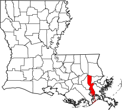
Location of River Ridge in Louisiana
Coordinates: 29°57′43″N90°13′04″W / 29.96194°N 90.21778°W / 29.96194; -90.21778
CountryUnited States
StateLouisiana
Parish Jefferson
Area
[1]
  Total3.55 sq mi (9.19 km2)
  Land2.80 sq mi (7.24 km2)
  Water0.75 sq mi (1.94 km2)
Population
 (2020)
  Total13,591
  Density4,860.87/sq mi (1,876.97/km2)
Time zone UTC-6 (CST)
  Summer (DST) UTC-5 (CDT)
ZIP Code
70123
Area code 504
GNIS feature ID546872

River Ridge is an unincorporated community and census-designated place (CDP) in Jefferson Parish, Louisiana, United States. It is a suburb of New Orleans. The population was 13,591 in 2020. [2]

Contents

History

The land that is now River Ridge was developed by French colonists and their descendants in the late 18th and early 19th centuries for large sugar plantations; these lined the Mississippi River in traditional French long-lot fashion. The plantations had relatively narrow waterfronts, in order to provide water access, and extended deeply back from the river. These plantations were developed by French colonists and their descendants; they depended on the labor of African slaves. Major landowners included members of the Trudeau and Sauve families. (Pierre Sauve (1805-1867) had a major plantation here known as Providence.)

The alignments of the major streets in the area are vestiges of this era. Sauve Road continues to be a main thoroughfare in River Ridge.

In 1849, a major flooding event known as Sauvé's Crevasse occurred. The crude river levee at the Sauve Providence plantation failed under pressure of high water on the Mississippi. The massive flood inundated much of the land to the east, including parts of New Orleans. This crevasse occurred where a former meander of the Mississippi River once branched to form the Metairie and Gentilly Ridges.

In the early 20th century, an interurban transit line was constructed through this area. It served to connect the cities of New Orleans and Kenner. It was aligned along the present course of Jefferson Highway, which was improved from earlier roads.

For many years the area remained rural farmland, until the post-World War II suburbanization era. Aided by funding under the G.I. Bill, which enabled veterans to buy houses, large-scale suburban development began in the early 1950s. By 1965, virtually all of the area along the Mississippi River between Harahan and Kenner was developed. This area at the time was known as "Little Farms", a name which well described its pre-urban history; this was also the place name officially recognized by the Post Office. (To this day Little Farms Avenue remains a major River Ridge thoroughfare.) Other subdivision names such as "East Bank" and "Rural Acres" were used as place names for the area at the time.

To eliminate confusion and create some sense of community identity, the area between Kenner, Harahan, Metairie, and the Mississippi River was officially renamed "River Ridge" in 1974.

In 2019, a baseball team from River Ridge won the Little League World Series, becoming the first team from Louisiana to do so. They also became the first team since 2001 to lose their opening game, but win the championship. [3]

Geography

River Ridge is located along a 3-mile (5 km) stretch of Jefferson Highway (Louisiana Highway 48). Its boundaries include Harahan to the east, Kenner to the northwest, Metairie to the north, and the Mississippi River to the southwest. Across the Mississippi is the unincorporated community of Waggaman.

River Ridge is located at 29°57′30″N90°13′19″W / 29.958265°N 90.221894°W / 29.958265; -90.221894 . According to the United States Census Bureau, the CDP has a total area of 3.55 square miles (9.19 km2), of which 2.80 square miles (7.24 km2) are land and 0.75 square miles (1.95 km2), or 21.18%, are water. [4]

Demographics

Historical population
CensusPop.Note
1970 15,713
1980 17,1469.1%
1990 14,800−13.7%
2000 14,588−1.4%
2010 13,494−7.5%
2020 13,5910.7%
U.S. Decennial Census [5] [6]
River Ridge racial composition as of 2020 [2]
RaceNumberPercentage
White (non-Hispanic)9,96573.32%
Black or African American (non-Hispanic)1,60411.8%
Native American 220.16%
Asian 1611.18%
Pacific Islander 20.01%
Other/Mixed 4663.43%
Hispanic or Latino 1,37110.09%

At the census [7] of 2000, there were 14,588 people, 6,030 households, and 4,082 families residing in the CDP. The population density was 5,181.6 inhabitants per square mile (2,000.6/km2). There were 6,325 housing units at an average density of 2,246.6 per square mile (867.4/km2). The racial makeup of the CDP was 86.76% White, 10.99% African American, 0.23% Native American, 0.78% Asian, 0.03% Pacific Islander, 0.45% from other races, and 0.76% from two or more races. Hispanic or Latinos of any race were 2.92% of the population. At the 2020 United States census, [2] there were 13,591 people, 5,546 households, and 3,579 families residing in the CDP, reflecting a slight population decline from the 2000 U.S. census. Its racial and ethnic makeup by 2020 was 73.32% non-Hispanic white, 11.8% Black or African American, 0.16% Native American, 1.18% Asian, 0.01% Pacific Islander, 3.43% two or more races, and 10.09% Hispanic or Latino American, reflecting the diversification of the United States at the 2020 census. [8] [9]

Culture

Education

Jefferson Parish Public Schools operates public schools. [10] Students are zoned to Hazel Park/Hilda Knoff School (formerly an elementary school) for grades PreK-8. [11] [12] Students are zoned to Riverdale High School in Jefferson. [13]

Formerly Hazel Park took elementary grades, [14] while Riverdale Middle School in Jefferson (now a part of Jefferson PK-8) took middle school grades. [15]

In regards to the advanced studies academies, students are zoned to Airline Park Academy. [16]

St. Matthew Catholic School (of the Roman Catholic Archdiocese of New Orleans) is in River Ridge. Many of the Catholic high schools are close by such as Archbishop Rummel High School and Archbishop Chapelle. Non-Catholic schools located nearby include St. Martin's Episcopal School, Kehoe-France, John Curtis, and Ridgewood Preparatory School,

Jefferson Parish Library operates the River Ridge Branch Library in River Ridge. [17] The library held its grand opening ceremony on Friday, May 4, 2018. [17]

Athletics

In August 2019, the Little League baseball team from River Ridge made history by being the first team from Louisiana to win the US Championship and World Series Final. [18]

Related Research Articles

<span class="mw-page-title-main">Avondale, Louisiana</span> Census-designated place in Louisiana, United States

Avondale is a census-designated place (CDP) in Jefferson Parish, Louisiana, United States, on the west bank of the Mississippi River. The population was 4,582 in 2020. It is part of the New Orleans–Metairie–Kenner metropolitan statistical area.

<span class="mw-page-title-main">Bridge City, Louisiana</span> Census-designated place in Louisiana, United States

Bridge City is an unincorporated community and census-designated place (CDP) in Jefferson Parish, Louisiana, United States. It was established in the 1930s during the construction of the Huey P. Long Bridge over the Mississippi River. The town is located on the south side of the river. It is part of the New Orleans–Metairie–Kenner metropolitan statistical area.

Elmwood is a census-designated place (CDP) in Jefferson Parish, Louisiana, United States, within the New Orleans–Metairie–Kenner metropolitan statistical area. The population was 4,635 at the 2010 census, and 5,649 in 2020. Elmwood was part of neighboring Jefferson's census area from 1960 to 1990. The ZIP Code serving Elmwood is 70123.

<span class="mw-page-title-main">Harahan, Louisiana</span> City in Louisiana, United States

Harahan is a city in the U.S. state of Louisiana and suburb of New Orleans. The city of Harahan is located in Jefferson Parish; its population was 9,116 at the 2020 census.

<span class="mw-page-title-main">Harvey, Louisiana</span> Census-designated place in Louisiana, United States

Harvey is a census-designated place (CDP) in Jefferson Parish, Louisiana, United States. Harvey is on the south side of the Mississippi River, within the New Orleans–Metairie–Kenner metropolitan statistical area. The majority-minority population was 20,348 at the 2010 census, down from 22,226 at the 2000 census. The 2020 census determined 22,236 people lived in the CDP.

<span class="mw-page-title-main">Jefferson, Louisiana</span> Census-designated place in Louisiana, United States

Jefferson is a census-designated place (CDP) in Jefferson Parish, Louisiana, United States, on the north side of the Mississippi River. Jefferson is part of the New Orleans–Metairie–Kenner metropolitan statistical area. The population was 11,193 at the 2010 census, and 10,533 in 2020. It is often known by locals as "Old Jefferson", but should not be confused with Old Jefferson in East Baton Rouge Parish, Louisiana.

<span class="mw-page-title-main">Kenner, Louisiana</span> City in Louisiana, United States

Kenner is a city in the U.S. state of Louisiana. It is the most populous city in Jefferson Parish, and is the largest incorporated suburban city of New Orleans. The population was 66,448 at the 2020 census, making it the sixth-most populous city in Louisiana.

<span class="mw-page-title-main">Marrero, Louisiana</span> Census-designated place in Louisiana, United States

Marrero is a census-designated place (CDP) in Jefferson Parish, Louisiana, United States. Marrero is on the south side of the Mississippi River, within the New Orleans–Metairie–Kenner metropolitan statistical area. The population was 32,382 at the 2020 U.S. census.

<span class="mw-page-title-main">Metairie, Louisiana</span> Census-designated place in Louisiana, United States

Metairie is a census-designated place (CDP) in Jefferson Parish, Louisiana, United States, and is part of the New Orleans metropolitan area. With a population of 143,507 in 2020, Metairie is the largest community in Jefferson Parish and was the fifth-largest CDP in the United States. It is an unincorporated area that would have been Louisiana's fourth-largest city behind Shreveport if incorporated.

<span class="mw-page-title-main">Terrytown, Louisiana</span> Census-designated place in Louisiana, United States

Terrytown is an unincorporated community and census-designated place (CDP) in Jefferson Parish, Louisiana, United States. It is on the "Westbank" of the Mississippi River. It is a suburb within the New Orleans–Metairie–Kenner metropolitan statistical area. The population was 23,319 at the 2010 census, and 25,278 in 2020.

Timberlane is a census-designated place (CDP) in Jefferson Parish, Louisiana, United States. The population was 10,364 in 2020. It is part of the New Orleans–Metairie–Kenner metropolitan statistical area.

Waggaman is a census-designated place and unincorporated community in Jefferson Parish, Louisiana, United States. Waggaman is on the West Bank of the Mississippi River, within the New Orleans–Metairie–Kenner metropolitan statistical area. The population was 9,835 at the 2020 census. The area was named for U.S. Senator George Augustus Waggaman (1782–1843).

Woodmere is an unincorporated community and census-designated place (CDP) in Jefferson Parish, Louisiana, United States. The population was 12,080 at the 2010 census, and 11,238 at the 2020 census. It is part of the New Orleans–Metairie–Kenner metropolitan statistical area.

<span class="mw-page-title-main">Poydras, Louisiana</span> Census-designated place in Louisiana, United States

Poydras is a census-designated place (CDP) in St. Bernard Parish, Louisiana, United States. The population was 3,886 at the 2000 census and 2,536 in 2020. It is part of the New Orleans–Metairie–Kenner Metropolitan Statistical Area. Poydras is on the East Bank of the Mississippi River, just upriver from the Plaquemines Parish line.

<span class="mw-page-title-main">Destrehan, Louisiana</span> Census-designated place in Louisiana, United States

Destrehan is a census-designated place (CDP) in St. Charles Parish, Louisiana, United States. At the 2020 census, its population was 11,340. It is located on the east bank of the Mississippi River. Destrehan is part of the New Orleans—Metairie—Kenner metropolitan statistical area.

Saint Rose is a census-designated place (CDP) in St. Charles Parish, Louisiana, United States. St. Rose is on the east bank of the Mississippi River, two miles (3 km) north of the Jefferson Parish border and is part of the Greater New Orleans metropolitan area. The population was 6,540 in the 2000 census, and 7,504 in 2020.

Wallace is a census-designated place (CDP) in St. John the Baptist Parish, Louisiana, United States. The population was 570 at the 2000 census. It is part of the New Orleans–Metairie–Kenner Metropolitan Statistical Area. The rural community is on the west bank of the Mississippi River and easily accessible to Interstate 10 via the Gramercy Bridge.

<span class="mw-page-title-main">Des Allemands, Louisiana</span> Census-designated place in Louisiana, United States

Des Allemands is an unincorporated community and census-designated place (CDP) in Lafourche and St. Charles parishes in the southeastern part of the U.S. state of Louisiana. The population was 2,179 at the 2020 census. The town, known as the "Catfish Capital of the Universe", is along the Bayou des Allemands, which is the boundary of Lafourche and St. Charles parishes. Lac des Allemands is located northwest of the town. The ZIP Code for Des Allemands is 70030.

<span class="mw-page-title-main">Riverdale High School (Jefferson Parish, Louisiana)</span> Public school in Jefferson, Louisiana, United States

Riverdale High School is a public secondary school in Jefferson, unincorporated Jefferson Parish, Louisiana, United States. It is a part of the Jefferson Parish Public Schools.

<span class="mw-page-title-main">Jefferson Parish Library</span>

Jefferson Parish Library (JPL) is the library system of Jefferson Parish, Louisiana. It has its headquarters in the East Bank Regional Library in Metairie, an unincorporated area in the parish.

References

  1. "2020 U.S. Gazetteer Files". United States Census Bureau. Retrieved March 20, 2022.
  2. 1 2 3 "2020 Race and Population Totals". data.census.gov. Retrieved December 28, 2021.
  3. Randhawa, Manny (August 25, 2019). "Louisiana beats Curacao for Little League crown". MLB.com.
  4. "Geographic Identifiers: 2010 Census Summary File 1 (G001): River Ridge CDP, Louisiana". American Factfinder. U.S. Census Bureau. Archived from the original on February 13, 2020. Retrieved July 20, 2018.
  5. "CENSUS OF POPULATION AND HOUSING (1790-2000)". U.S. Census Bureau . Retrieved July 17, 2010.
  6. Census area returned as Little Farms in 1970.
  7. "U.S. Census website". United States Census Bureau . Retrieved January 31, 2008.
  8. "Latinos account for over half of the country's population growth". NBC News. Retrieved January 5, 2022.
  9. "America is becoming more urban, more diverse and less white, 2020 Census reveals". PBS NewsHour. August 12, 2021. Retrieved January 5, 2022.
  10. "2010 CENSUS - CENSUS BLOCK MAP: River Ridge CDP, LA" (Archive). U.S. Census Bureau. Retrieved on May 18, 2014.
  11. "Elementary School Districts 2023-24 East Bank of Jefferson Parish Louisiana" (PDF). Jefferson Parish Public Schools . Retrieved March 2, 2024.
  12. "Middle School Districts 2023-24 East Bank of Jefferson Parish Louisiana" (PDF). Jefferson Parish Public Schools . Retrieved March 2, 2024.
  13. "High School Districts 2012-2013 East Bank of Jefferson Parish Louisiana Archived 2013-09-05 at the Wayback Machine ." (Archive) Jefferson Parish Public School System. Retrieved on May 18, 2014.
  14. "Elementary School Districts 2012-2013 East Bank of Jefferson Parish Louisiana Archived 2013-09-05 at the Wayback Machine " (Archive). Jefferson Parish Public School System. Retrieved on May 18, 2014.
  15. "Middle School Districts 2012-2013 East Bank of Jefferson Parish Louisiana Archived 2013-09-05 at the Wayback Machine " (Archive) Jefferson Parish Public School System. Retrieved on May 18, 2014.
  16. "East Bank Advanced Studies Attendance Zones Archived 2013-09-05 at the Wayback Machine " (Archive). Jefferson Parish Public School System. Retrieved on May 18, 2014.
  17. 1 2 "." Jefferson Parish Library. Retrieved on September 29, 2010.
  18. "Louisiana's Eastbank Little League Shuts Out Curacao to Win 2019 Little League Baseball® World Series". LittleLeague.org. August 25, 2019. Retrieved October 12, 2019.