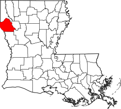
DeSoto Parish, Louisiana | |
---|---|
Parish of DeSoto | |
Country | United States |
State | Louisiana |
Region | North Louisiana |
Founded | 1843 |
Named for | settler, Marcel DeSoto |
Parish seat | Mansfield |
Largest municipality | Stonewall (area) Mansfield (population) |
Area | |
• Total | 2,320 km2 (895 sq mi) |
• Land | 2,270 km2 (876 sq mi) |
• Water | 50 km2 (19 sq mi) |
• percentage | 5 km2 (2.1 sq mi) |
Population (2020) | |
• Total | 26,812 |
• Density | 12/km2 (30/sq mi) |
Time zone | UTC-6 (CST) |
• Summer (DST) | UTC-5 (CDT) |
Area code | 318 |
Congressional district | 4th |
Website | DeSoto Parish Government |
DeSoto Parish (Spanish : Parroquia de DeSoto; French: Paroisse DeSoto) is a parish located in the U.S. state of Louisiana. The parish was formed in 1843. [1] At the 2020 U.S. census, the population was 26,812. [2] Its parish seat and most populous municipality is Mansfield. [3] DeSoto Parish is part of the Shreveport–Bossier City metropolitan statistical area.
It is a typical misconception that the parish was named after Hernando de Soto, the Spaniard who explored the future southeastern United States and discovered and named the Mississippi River. [4] The parish was in fact named after the unrelated Marcel DeSoto, who led the first group of European settlers there, to a settlement historically known as Bayou Pierre. [5] The parish's name is also commonly misspelled following the explorer's name as "De Soto Parish," but it is properly spelled following the settler's name as "DeSoto Parish." [6]
According to the U.S. Census Bureau, the parish has a total area of 895 square miles (2,320 km2), of which 876 square miles (2,270 km2) is land and 19 square miles (49 km2) (2.1%) is water. [7]
Census | Pop. | Note | %± |
---|---|---|---|
1850 | 8,023 | — | |
1860 | 13,298 | 65.7% | |
1870 | 14,962 | 12.5% | |
1880 | 15,603 | 4.3% | |
1890 | 19,860 | 27.3% | |
1900 | 25,063 | 26.2% | |
1910 | 27,689 | 10.5% | |
1920 | 29,376 | 6.1% | |
1930 | 31,016 | 5.6% | |
1940 | 31,803 | 2.5% | |
1950 | 24,398 | −23.3% | |
1960 | 24,248 | −0.6% | |
1970 | 22,764 | −6.1% | |
1980 | 25,727 | 13.0% | |
1990 | 25,346 | −1.5% | |
2000 | 25,494 | 0.6% | |
2010 | 26,656 | 4.6% | |
2020 | 26,812 | 0.6% | |
2021 (est.) | 26,919 | [2] | 0.4% |
U.S. Decennial Census [8] 1790-1960 [9] 1900-1990 [10] 1990-2000 [11] 2010 [12] |
Race | Number | Percentage |
---|---|---|
White (non-Hispanic) | 15,122 | 56.4% |
Black or African American (non-Hispanic) | 9,586 | 35.75% |
Native American | 242 | 0.9% |
Asian | 99 | 0.37% |
Pacific Islander | 12 | 0.05% |
Other/Mixed | 1,001 | 3.73% |
Hispanic or Latino | 762 | 2.84% |
As of the 2020 United States census, there were 26,812 people, 10,821 households, and 7,254 families residing in the parish. At the 2019 American Community Survey, [14] there were 10,821 households.
In 2019, the racial and ethnic makeup of the parish was 58.8% non-Hispanic or Latino white, 35.3% Black or African American, 0.9% American Indian and Alaska Native, 0.1% Asian, <0.0% Native Hawaiian and other Pacific Islander, 0.1% some other race, 1.9% two or more races, and 2.9% Hispanic or Latin American of any race. [15]
There were 10,821 households at the 2019 census estimates, and the home-ownership rate was 71.3%. Of the 7,716 owner-occupied units, 3,917 were married couples living together, 365 male households with no female present, and 896 female households with no male present. There was a 17.1% vacancy rate in the parish. The average family size was 3.07, [14] and the average household size was 2.50. [2]
In the parish, 75.5% were aged 18 and older, and 17.2% were aged 65 and older; the median age was 39.3, and 6.5% were aged 5 and under. Approximately 0.8% of the population were foreign-born, and 2.1% spoke a language other than English at home.
The median income for a household in the parish was $46,006; families had a median income of $56,323, married couples had a median income of $78,090, and non-family households had a median income of $25,314. An estimated 22% of the parish lived at or below the poverty line, and 30.6% of people aged under 18 were at or below the poverty line.
Public schools in DeSoto Parish are operated by the DeSoto Parish School Board. It is in the service area of Bossier Parish Community College. [16]
Year | Republican | Democratic | Third party(ies) | |||
---|---|---|---|---|---|---|
No. | % | No. | % | No. | % | |
2020 | 9,112 | 61.83% | 5,457 | 37.03% | 167 | 1.13% |
2016 | 8,068 | 59.76% | 5,165 | 38.26% | 267 | 1.98% |
2012 | 7,353 | 56.34% | 5,553 | 42.55% | 145 | 1.11% |
2008 | 6,883 | 56.16% | 5,242 | 42.77% | 132 | 1.08% |
2004 | 6,211 | 54.79% | 5,026 | 44.34% | 99 | 0.87% |
2000 | 5,260 | 49.64% | 5,036 | 47.53% | 300 | 2.83% |
1996 | 3,526 | 33.52% | 6,221 | 59.13% | 773 | 7.35% |
1992 | 3,643 | 33.06% | 5,671 | 51.46% | 1,707 | 15.49% |
1988 | 5,022 | 47.76% | 5,366 | 51.03% | 128 | 1.22% |
1984 | 5,989 | 55.77% | 4,642 | 43.23% | 108 | 1.01% |
1980 | 4,349 | 42.11% | 5,861 | 56.75% | 117 | 1.13% |
1976 | 3,601 | 43.14% | 4,630 | 55.46% | 117 | 1.40% |
1972 | 4,017 | 56.16% | 2,596 | 36.29% | 540 | 7.55% |
1968 | 974 | 11.37% | 3,400 | 39.70% | 4,190 | 48.93% |
1964 | 3,954 | 75.92% | 1,254 | 24.08% | 0 | 0.00% |
1960 | 1,603 | 36.11% | 1,183 | 26.65% | 1,653 | 37.24% |
1956 | 2,011 | 53.33% | 1,206 | 31.98% | 554 | 14.69% |
1952 | 2,303 | 57.85% | 1,678 | 42.15% | 0 | 0.00% |
1948 | 270 | 9.72% | 617 | 22.21% | 1,891 | 68.07% |
1944 | 538 | 22.45% | 1,858 | 77.55% | 0 | 0.00% |
1940 | 211 | 6.84% | 2,872 | 93.16% | 0 | 0.00% |
1936 | 93 | 3.83% | 2,337 | 96.17% | 0 | 0.00% |
1932 | 87 | 3.47% | 2,416 | 96.45% | 2 | 0.08% |
1928 | 517 | 26.32% | 1,445 | 73.57% | 2 | 0.10% |
1924 | 118 | 9.25% | 1,146 | 89.88% | 11 | 0.86% |
1920 | 56 | 4.39% | 1,219 | 95.61% | 0 | 0.00% |
1916 | 17 | 1.52% | 1,104 | 98.48% | 0 | 0.00% |
1912 | 11 | 1.20% | 815 | 88.68% | 93 | 10.12% |
Webster Parish is a parish located in the northwestern section of the U.S. state of Louisiana. The parish seat and largest city is Minden.
Sabine Parish is a parish located in the U.S. state of Louisiana. As of the 2020 census, the population was 22,155. The parish seat and largest town is Many.
Red River Parish is a parish located in the U.S. state of Louisiana. As of the 2020 census, the population was 7,620, making it the fourth-least populous parish in Louisiana. The parish seat and most populous municipality is Coushatta. It is one of the newer parishes, created in 1871 by the state legislature from parts of Bienville, Bossier, Caddo, Desoto and Natchitoches Parishes under Reconstruction. The plantation economy was based on cotton cultivation, highly dependent on enslaved African labor before the American Civil War.
Natchitoches Parish is a parish located in the U.S. state of Louisiana. As of the 2020 census, the population was 37,515. The parish seat and most populous municipality is Natchitoches, the largest by land area is Ashland, and the most density populated area is Campti. The parish was formed in 1805.
Bossier Parish is a parish located in the northwestern part of the U.S. state of Louisiana. At the 2020 census, the population was 128,746.
Bienville Parish is a parish located in the northwestern portion of the U.S. state of Louisiana. At the 2020 census, the population was 12,981. The parish seat and most populous municipality is Arcadia.
Bossier City is a city in Bossier Parish in the northwestern region of the state of Louisiana in the United States. It is the second-most populous city in the Shreveport–Bossier City metropolitan statistical area. In 2020, it had a total population of 62,701, up from 61,315 in 2010.
Blanchard is the suburban town in, and the second-largest municipality by population of Caddo Parish in the U.S. state of Louisiana. With a population of 3,538 at the 2020 U.S. census, it is part of the Shreveport–Bossier City metropolitan statistical area.
Greenwood is a suburban town in southern Caddo Parish, which is located in the northwest corner of the U.S. state of Louisiana. With a population of 3,166 at the 2020 United States census, it is the third most populous incorporated municipality in Caddo Parish after Shreveport and Blanchard. Part of the Shreveport-Bossier City metropolitan statistical area, it is located 15 miles west of downtown Shreveport.
Mooringsport is an incorporated municipality in the U.S. state of Louisiana, located in Caddo Parish. Part of the Shreveport–Bossier City metropolitan area and located approximately 18 miles (29 km) outside of the principal city of Shreveport, the town of Mooringsport had a population of 748 at the 2020 U.S. census.
Oil City is a town in Caddo Parish, Louisiana. The population was 1,008 at the time of the 2010 census. Oil City is located on Louisiana Highway 1, north of Caddo Lake. It is part of the Shreveport–Bossier City Metropolitan Statistical Area.
Keachi is a town in DeSoto Parish, Louisiana, United States. The population was 295 at the 2010 census. It is part of the Shreveport–Bossier City Metropolitan Statistical Area.
Mansfield is a small city in, and the parish seat of, DeSoto Parish, Louisiana, United States. Mansfield is part of the Shreveport–Bossier City metropolitan statistical area, with a 2020 population of 4,714.
Stonewall is a town in northern DeSoto Parish, Louisiana, United States. The population was 1,814 at the 2010 census, increasing to 2,273 in 2020. It is part of the Shreveport–Bossier City metropolitan statistical area.
Natchitoches, officially the City of Natchitoches, is a small city and the parish seat of Natchitoches Parish, Louisiana, United States. At the 2020 United States Census, the city's population was 18,039. Established in 1714 by Louis Juchereau de St. Denis as part of French Louisiana, the community was named after the indigenous Natchitoches people.
Caddo Parish is a parish located in the northwestern corner of the U.S. state of Louisiana. According to the 2020 U.S. census, the parish had a population of 237,848. The parish seat and largest city is Shreveport, which developed along the Red River.
Louisiana's 4th congressional district is a congressional district in the U.S. state of Louisiana. The district is located in the northwestern part of the state and is based in Shreveport-Bossier City. It also includes the cities of Minden, DeRidder, and Natchitoches.
The Shreveport–Bossier City metropolitan area, officially designated Shreveport–Bossier City by the U.S. Office of Management and Budget, or simply Greater Shreveport, is a metropolitan statistical area in northwestern Louisiana that covers three parishes: Caddo, Bossier, and DeSoto. At the 2020 United States census, the metropolitan region had a population of 393,406; its American Community Survey population was 397,590 per census estimates. With a 2010 census population of 439,000, it declined to become Louisiana's fourth largest metropolis at 394,706 residents at the 2019 census estimates.
The Shreveport–Bossier City–Minden combined statistical area is made up of four parishes in northwestern Louisiana. The statistical area consists of the Shreveport–Bossier City metropolitan statistical area and the Minden micropolitan statistical area. As of the 2010 census, the CSA had a population of 439,000. In 2013, OMB changed statistical definitions, subsuming Minden into the Shreveport metro ; in 2018, these changes were reversed.