Jefferson Davis Parish, Louisiana

Last updated

Jefferson Davis Parish
EltonUMCWM.JPG
Elton Methodist Church in Elton.
Map of Louisiana highlighting Jefferson Davis Parish.svg
Location within the U.S. state of Louisiana
Louisiana in United States.svg
Louisiana's location within the U.S.
Coordinates: 30°14′33″N92°40′24″W / 30.2425°N 92.6733°W / 30.2425; -92.6733
CountryFlag of the United States.svg United States
StateFlag of Louisiana.svg  Louisiana
FoundedJanuary 1, 1913
Named after Jefferson Davis
Seat Jennings
Largest cityJennings
Area
  Total
659 sq mi (1,710 km2)
  Land651 sq mi (1,690 km2)
  Water7.2 sq mi (19 km2)  1.1%
Population
 (2020)
  Total
32,250
  Density49/sq mi (19/km2)
Time zone UTC−6 (Central)
  Summer (DST) UTC−5 (CDT)
Congressional district 3rd

Jefferson Davis Parish (French : Paroisse de Jefferson Davis) is a parish located in the U.S. state of Louisiana. As of the 2020 census, the population was 32,250. [1] The parish seat is Jennings. [2] Jefferson Davis Parish is named after the president of the Confederacy during the American Civil War, Jefferson Davis. It is located in southwestern Louisiana and forms a part of the Acadiana region.

Contents

History

Jefferson Davis Parish was one of the last parishes to be organized in the state of Louisiana. It was originally a part of Imperial Calcasieu Parish, which contributed to five other parishes as the population increased in the area. The bill creating Jefferson Davis Parish was passed by the state legislature in 1912 but did not take effect until 1913. [3] Jefferson Davis Parish is part of the large, 22-parish Acadiana region of Louisiana, which is influenced by a large Francophone population. It was named after Jefferson Davis, a prominent planter and the President of the Confederate States of America.

The Jennings Oil Field in 1933 JenningsOilUSGS1933.jpg
The Jennings Oil Field in 1933

The first oil in Louisiana was drilled in 1901 in Evangeline, Acadia Parish, by W. Scott Heywood, who in 1932 was elected to the Louisiana State Senate. [4] The oil field was known as the Jennings Oil Field because Jennings was the nearest railroad stop to the oil field.

The parish was affected by Hurricane Rita in 2005, causing flooding and wind damage.

Geography

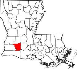
According to the U.S. Census Bureau, the parish has a total area of 660 square miles (1,700 km2), of which 651 square miles (1,690 km2) is land and 7.2 square miles (19 km2) (1.1%) is water. [5]

Jefferson Davis Parish comprises five incorporated towns including Elton, Fenton, Jennings, Lake Arthur, and Welsh. There are also many unincorporated areas that add to the interest and economic structure of the parish including Barnsdall, Buller, China, Coverdale, Edna, Fontenot, Foreman's Hall, Hathaway, Illinois Plant, Lacassine, Lauderdale, Panchoville, Pine Island, Raymond, Roanoke, Silverwood, Thornwell, Topsy, Verret, and Woodlawn. Interstate 10 runs east and west through the center of the parish, providing access to local markets. Additionally, the Union Pacific Railroad is centrally located within the parish and the Mermentau River, which connects to the Intracoastal Waterway and has a channel depth of nine feet, provides access to the Port of Mermentau. The Jennings Airport, with a runway length of 5,000 feet (1,500 m), is capable of landing a small jet and is located next to Interstate 10. Jefferson Davis Parish also attracts sportsmen to the Lacassine National Wildlife Refuge.

Adjacent parishes

Transportation

Major highways

Airports

Jennings, USA
Summary
Airport typePublic
LocationJennings, LA
Elevation  AMSL 23 ft / 7 m
Coordinates 30°14′33″N92°40′24″W / 30.24250°N 92.67333°W / 30.24250; -92.67333
Jefferson Davis Parish, Louisiana
Runways
Direction LengthSurface
ftm
08/265,0001,524Asphalt
13/313,5981,097Asphalt
17/352,000610Turf

Communities

Map of Jefferson Davis Parish, with municipal labels Map of Jefferson Davis Parish Louisiana With Municipal Labels.PNG
Map of Jefferson Davis Parish, with municipal labels

City

Towns

Village

Unincorporated areas

Census-designated places

Unincorporated communities

Demographics

Historical population
CensusPop.Note
1920 18,999
1930 19,7654.0%
1940 24,19122.4%
1950 26,2988.7%
1960 29,82513.4%
1970 29,554−0.9%
1980 32,1688.8%
1990 30,722−4.5%
2000 31,4352.3%
2010 31,5940.5%
2020 32,2502.1%
U.S. Decennial Census [6]
1790-1960 [7] 1900-1990 [8]
1990-2000 [9] 2010 [10]
Jefferson Davis Parish racial composition as of 2020 [11]
RaceNumberPercentage
White (non-Hispanic)24,85577.07%
Black or African American (non-Hispanic)5,13015.91%
Native American 1470.46%
Asian 1000.31%
Pacific Islander 40.01%
Other/Mixed 1,2803.97%
Hispanic or Latino 7342.28%

As of the 2020 United States census, there were 32,250 people, 11,726 households, and 8,149 families residing in the parish.

Education

Jefferson Davis Parish Public Schools operates the schools in the parish. [12]

Jeff Davis Parish is served by the Roman Catholic Diocese of Lafayette which has one school in the parish:

Jeff Davis Parish is served by one institution of higher education:

National Guard

C Company 3-156TH Infantry Battalion resides in Jennings, Louisiana. This unit as part of the 256th IBCT deployed twice to Iraq in 2004—5 and 2010.

Notable people

Politics

United States presidential election results for Jefferson Davis Parish, Louisiana [14]
Year Republican Democratic Third party(ies)
No.%No.%No.%
2024 11,47879.94%2,69918.80%1811.26%
2020 11,42376.97%3,20821.62%2101.41%
2016 10,77575.47%3,08021.57%4222.96%
2012 10,01472.91%3,48425.37%2361.72%
2008 9,27868.72%3,92329.06%3002.22%
2004 8,05561.93%4,74536.48%2071.59%
2000 6,94555.36%5,16241.14%4393.50%
1996 4,31133.31%6,89753.29%1,73513.40%
1992 4,51332.61%7,02250.74%2,30316.64%
1988 5,85145.74%6,79953.15%1411.10%
1984 8,29657.36%5,96241.22%2061.42%
1980 5,66746.73%6,14050.63%3202.64%
1976 3,60335.06%6,37662.04%2992.91%
1972 5,90365.96%2,55128.51%4955.53%
1968 2,21322.70%2,64127.08%4,89750.22%
1964 3,67342.52%4,96657.48%00.00%
1960 2,25125.84%5,90467.77%5576.39%
1956 4,17062.93%2,34635.41%1101.66%
1952 3,44749.03%3,58450.97%00.00%
1948 79321.78%1,71747.16%1,13131.06%
1944 1,15633.17%2,32966.83%00.00%
1940 1,05429.40%2,53170.60%00.00%
1936 60819.15%2,56780.85%00.00%
1932 51218.13%2,30881.73%40.14%
1928 1,12039.67%1,70360.33%00.00%
1924 88347.58%97352.42%00.00%
1920 89555.14%72844.86%00.00%
1916 20022.91%65675.14%171.95%

For most of the 20th Century, Jeff Davis was a Democratic-leaning parish, voting Republican only in landslide elections such as 1972 and 1984. However, like other Acadian parishes with large Cajun populations, Jeff Davis turned sharply right in the 21st century based on cultural issues and Democrats' discomfort with the oil and gas industry. [15]

See also

References

  1. "Census - Geography Profile: Jefferson Davis Parish, Louisiana". United States Census Bureau . Retrieved January 21, 2023.
  2. "Find a County". National Association of Counties. Archived from the original on May 31, 2011. Retrieved June 7, 2011.
  3. Gremillion, John Berton Gremillion. "Jefferson Davis Parish". library.mcneese.edu. McNeese State University. Archived from the original on March 27, 2015. Retrieved September 4, 2014.
  4. "Heywood, Walter Scott". Louisiana Historical Association, A Dictionary of Louisiana Biography. Archived from the original on February 25, 2010. Retrieved January 30, 2011.
  5. "2010 Census Gazetteer Files". United States Census Bureau. August 22, 2012. Archived from the original on September 28, 2013. Retrieved September 1, 2014.
  6. "U.S. Decennial Census". United States Census Bureau. Retrieved September 1, 2014.
  7. "Historical Census Browser". University of Virginia Library. Retrieved September 1, 2014.
  8. "Population of Counties by Decennial Census: 1900 to 1990". United States Census Bureau. Retrieved September 1, 2014.
  9. "Census 2000 PHC-T-4. Ranking Tables for Counties: 1990 and 2000" (PDF). United States Census Bureau. Archived (PDF) from the original on March 27, 2010. Retrieved September 1, 2014.
  10. "State & County QuickFacts". United States Census Bureau. Archived from the original on June 19, 2011. Retrieved August 9, 2013.
  11. "Explore Census Data". data.census.gov. Retrieved December 29, 2021.
  12. "2020 CENSUS - SCHOOL DISTRICT REFERENCE MAP: Jefferson Davis Parish, LA" (PDF). U.S. Census Bureau . Retrieved November 23, 2023. - Text list
  13. "Our Colleges". Louisiana's Technical and Community Colleges . Retrieved June 3, 2021.
  14. Leip, David. "Dave Leip's Atlas of U.S. Presidential Elections". uselectionatlas.org.
  15. Martin, Jonathan (November 16, 2019). "Why the Louisiana Governor's Race Is So Close". The New York Times.

Geology

Hydrology