Welsh, Louisiana

Last updated

Welsh, Louisiana
Town
Calkins Orvis House Welsh Louisiana 2019.jpg
The historic Calkins-Orvis House.
Jefferson Davis Parish Louisiana Incorporated and Unincorporated areas Welsh Highlighted.svg
Location of Welsh in Jefferson Davis Parish, Louisiana.
Louisiana in United States (US48).svg
Location of Louisiana in the United States
Coordinates: 30°14′15″N92°49′44″W / 30.23750°N 92.82889°W / 30.23750; -92.82889
CountryUnited States
StateLouisiana
Parish Jefferson Davis
FoundedMarch 15, 1888
Government
  MayorKarl Arceneaux (elected 2020)
Area
[1]
  Total
6.44 sq mi (16.69 km2)
  Land6.32 sq mi (16.38 km2)
  Water0.12 sq mi (0.31 km2)
Elevation
23 ft (7 m)
Population
 (2020)
  Total
3,333
  Density527.21/sq mi (203.54/km2)
Time zone UTC-6 (CST)
  Summer (DST) UTC-5 (CDT)
ZIP code
70591 [2]
Area code 337
FIPS code 22-80430
Website http://www.townofwelsh.com/

Welsh is a town in Jefferson Davis Parish, Louisiana. The population was 3,226 at the time of the 2010 census. It is part of the Jennings Micropolitan Statistical Area.

Contents

History

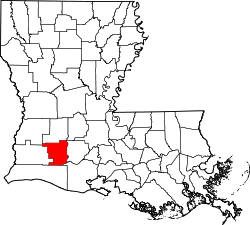
Welsh was originally a homestead owned by Miles Welsh, a Pennsylvania man who went to Louisiana to seek a warmer climate for his health. He died in 1868, but his son Henry built a cabin on the current-day town site. [3] The home sat along the main stagecoach route across south Louisiana, and Welsh's home and store was the primary stop for travelers between New Iberia and Texas. In 1880, Welsh donated right-of-way to the Louisiana Western Rail Road (later Southern Pacific), which built a station. [4] The town of Welsh was platted in 1880 [4] and incorporated on March 15, 1888, [5] with Henry Welsh elected its first mayor a few months before his death that October. Initially part of the old Imperial Calcasieu Parish, in 1913 Welsh became part of the newly established Jefferson Davis Parish. [4]

Geography

Welsh is located at 30°14′15″N92°49′14″W / 30.23750°N 92.82056°W / 30.23750; -92.82056 (30.237419, -92.820593). [6]

According to the United States Census Bureau, the town has a total area of 6.3 square miles (16.4 km2), of which 6.2 square miles (16.1 km2) is land and 0.1 square mile (0.3 km2) (1.89%) is water.

Demographics

Historical population
CensusPop.Note
1890 200
1900 32060.0%
1910 1,250290.6%
1920 1,45616.5%
1930 1,5144.0%
1940 1,82220.3%
1950 2,41632.6%
1960 3,33237.9%
1970 3,203−3.9%
1980 3,5159.7%
1990 3,299−6.1%
2000 3,3802.5%
2010 3,226−4.6%
2020 3,3333.3%
U.S. Decennial Census [7]
Welsh racial composition as of 2020 [8]
RaceNumberPercentage
White (non-Hispanic)2,42972.88%
Black or African American (non-Hispanic)66119.83%
Native American 40.12%
Asian 80.24%
Other/Mixed 1685.04%
Hispanic or Latino 631.89%

As of the 2020 United States census, there were 3,333 people, 1,128 households, and 765 families residing in the town.

Notable people

Education

Jefferson Davis Parish Public Schools operates public schools in Welsh. Schools serving Welsh include Welsh Elementary School (PK–5) in Welsh, Welsh - Roanoke Jr. High (6–8) in nearby Roanoke, and Welsh High School (9–12) in Welsh.

Jefferson Davis Parish Library operates the McBurney Memorial Branch at 301 South Sarah Street.

See also

References

  1. "2020 U.S. Gazetteer Files". United States Census Bureau. Retrieved March 20, 2022.
  2. "Welsh LA ZIP Code". zipdatamaps.com. 2023. Retrieved June 16, 2023.
  3. Bradshaw, Jim (October 28, 1997). "Welsh was way station in stage coach days". The Daily Advertiser. p. 51. Retrieved December 31, 2024.
  4. 1 2 3 Bradshaw, Jim (June 2004). "Welsh was way station in stage coach days". USGenWeb.
  5. "Welcome".
  6. "US Gazetteer files: 2010, 2000, and 1990". United States Census Bureau. February 12, 2011. Retrieved April 23, 2011.
  7. "Census of Population and Housing". Census.gov. Retrieved June 4, 2015.
  8. "Explore Census Data". data.census.gov. Retrieved December 29, 2021.