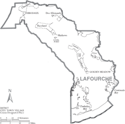
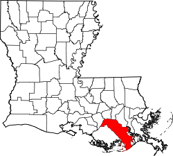
Lafourche Parish, Louisiana

Last updated

Lafourche Parish
Lafourche Parish Courthouse.jpg
Lafourche Parish Courthouse
Map of Louisiana highlighting Lafourche Parish.svg
Location within the U.S. state of Louisiana
Louisiana in United States.svg
Louisiana's location within the U.S.
Coordinates: 29°29′N90°24′W / 29.49°N 90.4°W / 29.49; -90.4
CountryFlag of the United States.svg United States
StateFlag of Louisiana.svg  Louisiana
Founded1807
Named for la fourche, French for the fork
Seat Thibodaux
Largest cityThibodaux
Area
  Total1,474 sq mi (3,820 km2)
  Land1,068 sq mi (2,770 km2)
  Water406 sq mi (1,050 km2)  28%
Population
 (2020)
  Total97,557
  Density91.35/sq mi (35.27/km2)
Time zone UTC−6 (Central)
  Summer (DST) UTC−5 (CDT)
Congressional districts 1st, 6th
Website www.lafourchegov.org

Lafourche Parish (French : Paroisse de la Fourche) is a parish located in the south of the U.S. state of Louisiana. The parish seat is Thibodaux. [1] The parish was formed in 1807. [2] It was originally the northern part of Lafourche Interior Parish, which consisted of the present parishes of Lafourche and Terrebonne. Lafourche Parish was named after the Bayou Lafourche. [3] City buildings have been featured in television and movies, such as in Fletch Lives , due to its architecture and rich history. At the 2020 census, its population was 97,557. [4]

Contents

Long a center of sugar cane plantations and sugar production, in November 1887 the parish was the site of the Thibodaux Massacre. After state militia were used to suppress a massive Knights of Labor strike involving 10,000 workers in four parishes, many African Americans retreated to Thibodaux. Local paramilitary forces attacked the men and their families, killing an estimated 50 persons. Hundreds more were missing, wounded, and presumed dead in one of the deadliest incidents of labor suppression and racial terrorism.

Lafourche Parish is part of the Houma-Thibodaux metropolitan statistical area. People of the state-recognized Native American Houma Tribe live in both Lafourche and Terrebonne parishes.

History

South Louisiana became known as “Sugarland”, and Lafourche one of the sugar parishes, where sugar cane plantations were established before and after the Civil War. They required the labor of large numbers of enslaved African Americans. In the postbellum era, they constituted from 50 to 80 percent of the population in most of the sugar parishes. [5]

Particularly after Reconstruction, whites in the parish used violence and intimidation against the large population of freedmen to suppress Republican voting and re-establish white supremacy, but were less successful than in North Louisiana until after disenfranchisement of blacks at the turn of the century. [5] From 1877 through the early 20th century, there were 52 lynchings of African Americans in Lafourche Parish. Most of the deaths were due to white suppression of labor unrest in 1887; blacks were skilled sugar workers and had begun to organize for better wages and conditions. [5] Some 10,000 workers had struck in Lafourche and three other parishes during the critical harvest period. At the request of the planters, the state sent in militia against the workers to break the strike.

In what was called the Thibodaux Massacre of November 22, 1887, local whites organized by leaders of the town killed up to 50 blacks who had taken refuge in the African-American quarters after a major Knights of Labor strike was called on sugar plantations. Hundreds more were wounded or missing, and presumed dead. [6]

The total deaths in this parish due to this racial terrorism were the highest of any parish in the state and nearly twice as high as some others among the six parishes with the highest totals. [7] In general, most of the lynching and racial terrorism took place in the late 19th and early 20th centuries.

On August 29, 2021, Hurricane Ida made landfall in Port Fourchon at 16:55 UTC as a category 4 hurricane with maximum sustained winds of 150 mph. Additional reports surveyed by ships in Port Fourchon reported wind gusts up to 194 knots. [8] In Golden Meadow, LA, the National Weather Service recorded storm surge measurements of 10.1 ft. [8] It was the strongest storm on record to make landfall in Lafourche Parish and at the time the 5th costliest hurricane in United States history. [9]

Geography

According to the U.S. Census Bureau, the parish has a total area of 1,474 square miles (3,820 km2), of which 1,068 square miles (2,770 km2) is land and 406 square miles (1,050 km2) (28%) is water. [10] To the south of the parish is the Gulf of Mexico.

Major highways

Adjacent parishes

National protected area

Communities

Map of Lafourche Parish with municipal labels Map of Lafourche Parish Louisiana With Municipal Labels.PNG
Map of Lafourche Parish with municipal labels

City

Towns

Census-designated places

Other areas

Demographics

Historical population
CensusPop.Note
1810 1,995
1820 3,75588.2%
1830 5,50346.6%
1840 7,30332.7%
1850 9,53230.5%
1860 14,04447.3%
1870 14,7194.8%
1880 19,11329.9%
1890 22,09515.6%
1900 28,88230.7%
1910 33,11114.6%
1920 30,344−8.4%
1930 32,4196.8%
1940 38,61519.1%
1950 42,2099.3%
1960 55,38131.2%
1970 68,94124.5%
1980 82,48319.6%
1990 85,8604.1%
2000 89,9744.8%
2010 96,3187.1%
2020 97,5571.3%
U.S. Decennial Census [11]
1790-1960 [12] 1900-1990 [13]
1990-2000 [14] 2010-2013 [15]
Lafourche Parish racial composition as of 2020 [16]
RaceNumberPercentage
White (non-Hispanic)70,72272.49%
Black or African American (non-Hispanic)14,53214.9%
Native American 2,4272.49%
Asian 7590.78%
Pacific Islander 310.03%
Other/Mixed 3,4143.5%
Hispanic or Latino 5,6725.81%

As of the 2020 United States census, there were 97,557 people, 36,759 households, and 25,224 families residing in the parish. The average household size was 2.60 and the average family size was 3.04.

In 2000, there were 89,794 people living in the parish. The racial makeup of Lafourche was 82.85% White, 12.61% Black or African American, 2.30% American Indian and Alaska Native, 0.67% Asian, 0.02% Pacific Islander, 0.58% from other races, and 0.97% from two or more races; 1.43% of the population were Hispanic or Latino American of any race. Among the population, 19.12% reported speaking French or Cajun French at home, while 1.51% spoke Spanish. [17]

Up from $34,910 in 2000, the median income of a household in the parish was $51,339 according to the 2019 American Community Survey. In 2000, males had a median income of $34,600 versus $19,484 for females. The per capita income for the parish was $15,809. About 13.20% of families and 16.50% of the population were below the poverty line, including 21.90% of those under age 18 and 18.30% of those age 65 or over.

Education

The parish is zoned to Lafourche Parish Public Schools. [18]

Residents of select portions of Lafourche Parish (particularly in parts of Grand Bois and Bourg) may attend schools in the Terrebonne Parish School District. [19]

High schools

Colleges and universities

The parish is in the service area of Fletcher Technical Community College. [20] Additionally, a Delgado Community College document stated that Lafourche Parish was in the college's service area. [21]

National Guard

D Company 2-156 Infantry Battalion of the 256TH Infantry Brigade Combat Team resides in Thibodaux, Louisiana

Notable people

Politics

United States presidential election results for Lafourche Parish, Louisiana [22]
Year Republican Democratic Third party
No.%No.%No.%
2020 36,02479.37%8,67219.11%6921.52%
2016 31,95976.74%8,42320.23%1,2633.03%
2012 28,59273.17%9,62324.63%8602.20%
2008 27,08971.49%9,66225.50%1,1423.01%
2004 22,73460.04%14,41738.08%7131.88%
2000 18,57553.92%14,62742.46%1,2473.62%
1996 12,10534.99%18,81054.37%3,68110.64%
1992 12,74435.75%16,18245.40%6,71918.85%
1988 16,15250.19%15,01346.65%1,0143.15%
1984 20,93065.40%10,18631.83%8892.78%
1980 14,95148.51%14,22246.15%1,6455.34%
1976 11,43443.53%14,13153.80%7012.67%
1972 13,93667.20%5,71327.55%1,0885.25%
1968 4,79722.60%5,51625.99%10,91051.41%
1964 6,16433.85%12,04566.15%00.00%
1960 2,93018.25%12,24476.26%8815.49%
1956 5,74160.25%3,46636.38%3213.37%
1952 3,73940.93%5,39659.07%00.00%
1948 1,24721.09%1,58626.82%3,08052.09%
1944 87514.94%4,98085.06%00.00%
1940 1,06523.17%3,53176.83%00.00%
1936 1,63042.59%2,19557.36%20.05%
1932 36412.18%2,62387.78%10.03%
1928 24310.86%1,99489.14%00.00%
1924 61147.40%67852.60%00.00%
1920 1,04475.60%33724.40%00.00%
1916 1578.11%62932.51%1,14959.38%
1912 31526.90%66756.96%18916.14%

See also

Related Research Articles

<span class="mw-page-title-main">Terrebonne Parish, Louisiana</span> Parish in Louisiana, United States

Terrebonne Parish is a parish located in the southern part of the U.S. state of Louisiana. At the 2020 census, the population was 109,580. The parish seat is Houma. The parish was founded in 1822. Terrebonne Parish is part of the Houma-Thibodaux metropolitan statistical area.

Chackbay is a census-designated place (CDP) in northern Lafourche Parish, Louisiana, United States. The population was 5,370 in 2020. It is part of the Houma–Bayou Cane–Thibodaux metropolitan statistical area.

Cut Off is a census-designated place (CDP) on the Bayou Lafourche in Lafourche Parish, Louisiana, United States. The population was 5,533 in 2020. It is part of the Houma–Bayou Cane–Thibodaux metropolitan statistical area. Cut Off's ZIP code is 70345, the area code is 985 and local telephone prefixes are 325, 632 and 693.

Galliano is an unincorporated community and census-designated place (CDP) on the Bayou Lafourche in Lafourche Parish, Louisiana, United States. As of 2020, its population was 7,100. It is part of the Houma–Bayou Cane–Thibodaux metropolitan statistical area.

<span class="mw-page-title-main">Golden Meadow, Louisiana</span> Town in Louisiana, United States

Golden Meadow is a town along Bayou Lafourche in Lafourche Parish, Louisiana, United States. The population was 1,761 in 2020. It is part of the Houma–Bayou Cane–Thibodaux metropolitan statistical area. Its main source of revenue is the oil and gas industry. The fishing and seafood industries also have strong economic impacts, with charter fishing, restaurants, and lodging actively serving patrons. The town was once known as a speed trap, but it has since been bypassed by Hwy 3235 and city traffic has been reduced to mostly locals; however, the speed limit is reduced to 50 mph on Hwy 3235 and said highway is still patrolled heavily. As in other places in Louisiana, there is a noticeable presence of Cajun culture, music, and cuisine.

<span class="mw-page-title-main">Larose, Louisiana</span> Census-designated place in Louisiana, United States

Larose is an unincorporated community and census-designated place (CDP) in Lafourche Parish, Louisiana, United States. The population was 6,763 in 2020. It is part of the Houma–Bayou Cane–Thibodaux metropolitan statistical area.

<span class="mw-page-title-main">Lockport, Louisiana</span> Town in Louisiana, United States

Lockport is a town on Bayou Lafourche in Lafourche Parish, Louisiana, United States. The population was 2,490 in 2020. It is part of the Houma–Bayou Cane–Thibodaux metropolitan statistical area.

Mathews is a census-designated place (CDP) on Bayou Lafourche in Lafourche Parish, Louisiana, United States. The population was 2,273 in 2020. It is part of the Houma–Bayou Cane–Thibodaux metropolitan statistical area.

<span class="mw-page-title-main">Raceland, Louisiana</span> Census-designated place in Louisiana, United States

Raceland is an unincorporated community and census-designated place (CDP) on Bayou Lafourche in Lafourche Parish, Louisiana, United States. The population was 9,768 in 2020. It is part of the Houma–Bayou Cane–Thibodaux metropolitan statistical area.

<span class="mw-page-title-main">Thibodaux, Louisiana</span> City in Louisiana, United States

Thibodaux is a city in, and the parish seat of, Lafourche Parish, Louisiana, United States, along the banks of Bayou Lafourche in the northwestern part of the parish. The population was 15,948 at the 2020 census. Thibodaux is a principal city of the Houma–Bayou Cane–Thibodaux metropolitan statistical area.

Bayou Cane is a census-designated place (CDP) in Terrebonne Parish, Louisiana, United States. It is located just north of Houma and had a population of 19,770 in 2020.

<span class="mw-page-title-main">Chauvin, Louisiana</span> CDP in Louisiana, United States

Chauvin is a census-designated place (CDP) in Terrebonne Parish, Louisiana, United States. The population was 2,575 in 2020.. It is part of the Houma–Bayou Cane–Thibodaux metropolitan statistical area.

<span class="mw-page-title-main">Houma, Louisiana</span> City in Louisiana, United States

Houma is the largest city in and the parish seat of Terrebonne Parish in the U.S. state of Louisiana. It is also the largest principal city of the Houma–Bayou Cane–Thibodaux metropolitan statistical area. The city's government was absorbed by the parish in 1984, which currently operates as the Terrebonne Parish Consolidated Government.

Montegut is a census-designated place (CDP) in Terrebonne Parish, Louisiana, United States. The population was 1,540 at the 2010 census. It is part of the Houma–Bayou Cane–Thibodaux metropolitan statistical area. Montegut was the primary filming location for the 2012 film Beasts of the Southern Wild.

<span class="mw-page-title-main">Des Allemands, Louisiana</span> Census-designated place in Louisiana, United States

Des Allemands is an unincorporated community and census-designated place (CDP) in Lafourche and St. Charles parishes in the southeastern part of the U.S. state of Louisiana. The population was 2,179 at the 2020 census. The town, known as the "Catfish Capital of the Universe", is along the Bayou des Allemands, which is the boundary of Lafourche and St. Charles parishes. Lac des Allemands is located northwest of the town. The ZIP Code for Des Allemands is 70030.

<span class="mw-page-title-main">Houma–Thibodaux metropolitan area</span> Region of southern Louisiana, United States

The Houma–Thibodaux metropolitan area, officially the Houma–Thibodaux metropolitan statistical area, is a metropolitan statistical area in the Acadiana region of southern Louisiana, United States that covers two parishes—Lafourche and Terrebonne. The metropolis had a 2020 census-tabulated population of 207,137.

<span class="mw-page-title-main">Kraemer, Louisiana</span> Census-designated place in Louisiana, United States

Kraemer is a census-designated place (CDP) in Lafourche Parish, Louisiana, United States. As of the 2010 census, its population was 934. Its ZIP code is 70371. It is also known as Bayou Boeuf.

Bayou Blue is an unincorporated community and census-designated place in Lafourche and Terrebonne parishes, Louisiana, United States. Its population was 12,352 as of the 2010 census.

Bayou Country Club is an unincorporated community and census-designated place in Lafourche Parish, Louisiana, United States. Its population was 1,396 as of the 2010 census. Louisiana Highway 1 passes through the community.

Choctaw is an unincorporated community and census-designated place in Lafourche Parish, Louisiana, United States. Its population was 879 as of the 2010 census.

References

  1. "Find a County". National Association of Counties. Retrieved June 7, 2011.
  2. "Lafourche Parish". Center for Cultural and Eco-Tourism. Retrieved September 6, 2014.
  3. Gannett, Henry (1905). The Origin of Certain Place Names in the United States. Government Printing Office. p. 179.
  4. "2020 Race and Population Totals". United States Census Bureau. Retrieved October 28, 2021.
  5. 1 2 3 Pfeifer, Michael James (2004). Rough Justice: Lynching and American Society, 1874-1947. University of Illinois Press. pp. 75–77.
  6. Bell, Ellen Baker, "Thibodaux Massacre (1887)", KnowLA Encyclopedia of Louisiana, 15 September 2011, access-date 23 April 2017
  7. Lynching in America, Third Edition: Supplement by County Archived 2017-10-23 at the Wayback Machine , p. 6, Equal Justice Initiative, Mobile, AL, 2017
  8. 1 2 John L. Beven II; et al. (April 4, 2022). "Hurricane Ida" (PDF). nhc.noaa.gov. Retrieved February 10, 2023.
  9. "Costliest U.S. Tropical Cyclones" (PDF). ncei.noaa.gov. Archived (PDF) from the original on May 17, 2022. Retrieved February 10, 2023.
  10. "2010 Census Gazetteer Files". United States Census Bureau. August 22, 2012. Archived from the original on September 28, 2013. Retrieved September 1, 2014.
  11. "U.S. Decennial Census". United States Census Bureau. Archived from the original on May 7, 2015. Retrieved September 1, 2014.
  12. "Historical Census Browser". University of Virginia Library. Retrieved September 1, 2014.
  13. "Population of Counties by Decennial Census: 1900 to 1990". United States Census Bureau. Retrieved September 1, 2014.
  14. "Census 2000 PHC-T-4. Ranking Tables for Counties: 1990 and 2000" (PDF). United States Census Bureau. Archived (PDF) from the original on March 27, 2010. Retrieved September 1, 2014.
  15. "State & County QuickFacts". United States Census Bureau. Archived from the original on June 6, 2011. Retrieved August 10, 2013.
  16. "Explore Census Data". data.census.gov. Retrieved December 28, 2021.
  17. "Language Map Data Center".
  18. "2020 CENSUS - SCHOOL DISTRICT REFERENCE MAP: Lafourche Parish, LA" (PDF). U.S. Census Bureau. Archived (PDF) from the original on July 31, 2022. Retrieved July 31, 2022. - Text list
  19. "SCHOOL ATTENDANCE BOUNDARIES Archived 2016-12-02 at the Wayback Machine ." Lafourche Parish Public Schools. Retrieved on December 2, 2016.
  20. "Our Colleges". Louisiana's Technical and Community Colleges . Retrieved June 3, 2021.
  21. "The Economic Value of Delgado Community College" (PDF). Delgado Community College . Retrieved March 9, 2024. For the purposes of this analysis, the Delgado Service Area is comprised of [...]Lafourche,[...]
  22. Leip, David. "Dave Leip's Atlas of U.S. Presidential Elections". uselectionatlas.org. Retrieved March 6, 2018.

29°29′N90°24′W / 29.49°N 90.40°W / 29.49; -90.40