Kraemer, Louisiana | |
|---|---|
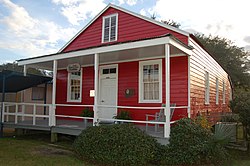 "Little Red Schoolhouse" of Bayou Boeuf Elementary School | |
 Kraemer  Kraemer | |
| Coordinates: 29°52′01″N90°41′49″W / 29.86694°N 90.69694°W | |
| Country | United States |
| State | Louisiana |
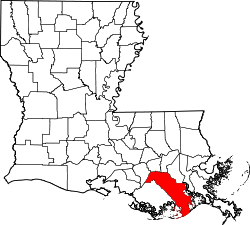
| Parish | Lafourche |
| Area | |
• Total | 5.32 sq mi (13.79 km2) |
| • Land | 5.25 sq mi (13.59 km2) |
| • Water | 0.077 sq mi (0.20 km2) |
| Elevation | 3 ft (0.91 m) |
| Population (2020) | |
• Total | 877 |
| • Density | 167.1/sq mi (64.51/km2) |
| Time zone | UTC-6 (Central (CST)) |
| • Summer (DST) | UTC-5 (CDT) |
| ZIP code | 70371 |
| Area code | 985 |
| GNIS feature ID | 536230 [2] |
Kraemer is a census-designated place (CDP) in Lafourche Parish, Louisiana, United States. [2] As of the 2010 census, its population was 934. [3] Its ZIP code is 70371. [4] It is also known as Bayou Boeuf. [5]