Area code 985

Last updated
Area code 985 as of 2001-2007. Area codes LA.png
Area code 985 as of 2001–2007.

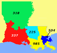
Area code 985 is the telephone area code for southeastern Louisiana, excluding the inner ring of the New Orleans area. The area code was created in 2001 when it was split off from area code 504.

Contents

Area code 985 also used to include areas southeast of New Orleans. However, in 2007, these areas switched back to 504. These communities are on both sides of the Mississippi River in "lower" Plaquemines Parish, including Pointe à la Hache on the east bank, with Port Sulphur, Buras, and Boothville on the west bank. The area's local switching facilities were almost destroyed due to flooding from Hurricane Katrina. Since the nearest switching facilities were in New Orleans, it was decided to put these downriver communities back in 504. Permissive use of 504 alongside 985 to reach these areas once again began on July 29, 2007; mandatory use of 504 began on July 1, 2008.

Cities covered by area code 985

See also

Related Research Articles

<span class="mw-page-title-main">Louisiana</span> U.S. state

Louisiana is a state in the Deep South and South Central regions of the United States. It borders Texas to the west, Arkansas to the north, and Mississippi to the east. Of the 50 U.S. states, it ranks 20th in land area and the 25th in population, with roughly 4.6 million residents. Reflecting its French heritage, Louisiana is the only U.S. state with political subdivisions termed parishes, which are equivalent to counties, making it one of only two U.S. states not subdivided into counties. Baton Rouge is the state's capital, and New Orleans, a French Louisiana region, is its largest city with a population of about 383,000 people. Louisiana has a coastline with the Gulf of Mexico to the south; a large part of its eastern boundary is demarcated by the Mississippi River.

<span class="mw-page-title-main">New Orleans</span> Consolidated city-parish in Louisiana, United States

New Orleans is a consolidated city-parish located along the Mississippi River in the southeastern region of the U.S. state of Louisiana. With a population of 383,997 according to the 2020 U.S. census, it is the most populous city in Louisiana and the French Louisiana region; third most populous city in the Deep South; and the twelfth-most populous city in the southeastern United States. Serving as a major port, New Orleans is considered an economic and commercial hub for the broader Gulf Coast region of the United States.

<span class="mw-page-title-main">St. John the Baptist Parish, Louisiana</span> Parish in Louisiana, United States

St. John the Baptist Parish is a parish located in the U.S. state of Louisiana. At the 2020 census, the population was 42,477. The parish seat is Edgard, an unincorporated area, and the largest city is LaPlace, which is also unincorporated.

<span class="mw-page-title-main">Jefferson Parish, Louisiana</span> Parish in Louisiana, United States

Jefferson Parish is a parish in the U.S. state of Louisiana. As of the 2020 census, the population was 440,781. Its parish seat is Gretna, its largest community is Metairie, and its largest incorporated city is Kenner. Jefferson Parish is included in the Greater New Orleans area.

<span class="mw-page-title-main">Harvey, Louisiana</span> Census-designated place in Louisiana, United States

Harvey is a census-designated place (CDP) in Jefferson Parish, Louisiana, United States. Harvey is on the south side of the Mississippi River, within the New Orleans–Metairie–Kenner metropolitan statistical area. The majority-minority population was 20,348 at the 2010 census, down from 22,226 at the 2000 census. The 2020 census determined 22,236 people lived in the CDP.

<span class="mw-page-title-main">Jefferson, Louisiana</span> Census-designated place in Louisiana, United States

Jefferson is a census-designated place (CDP) in Jefferson Parish, Louisiana, United States, on the north side of the Mississippi River. Jefferson is part of the New Orleans–Metairie–Kenner metropolitan statistical area. The population was 11,193 at the 2010 census, and 10,533 in 2020. It is often known by locals as "Old Jefferson", but should not be confused with Old Jefferson in East Baton Rouge Parish, Louisiana.

<span class="mw-page-title-main">Metairie, Louisiana</span> Census-designated place in Louisiana, United States

Metairie is a census-designated place (CDP) in Jefferson Parish, Louisiana, United States, and is part of the New Orleans metropolitan area. With a population of 143,507 in 2020, Metairie is the largest community in Jefferson Parish and was the fifth-largest CDP in the United States. It is an unincorporated area that would have been Louisiana's fourth-largest city behind Shreveport if incorporated.

<span class="mw-page-title-main">River Ridge, Louisiana</span> Census-designated place in Louisiana, United States

River Ridge is an unincorporated community and census-designated place (CDP) in Jefferson Parish, Louisiana, United States. It is a suburb of New Orleans. The population was 13,591 in 2020.

Waggaman is a census-designated place and unincorporated community in Jefferson Parish, Louisiana, United States. Waggaman is on the West Bank of the Mississippi River, within the New Orleans–Metairie–Kenner metropolitan statistical area. The population was 9,835 at the 2020 census. The area was named for U.S. Senator George Augustus Waggaman (1782–1843).

Cut Off is a census-designated place (CDP) on the Bayou Lafourche in Lafourche Parish, Louisiana, United States. The population was 5,533 in 2020. It is part of the Houma–Bayou Cane–Thibodaux metropolitan statistical area. Cut Off's ZIP code is 70345, the area code is 985 and local telephone prefixes are 325, 632 and 693.

<span class="mw-page-title-main">Destrehan, Louisiana</span> Census-designated place in Louisiana, United States

Destrehan is a census-designated place (CDP) in St. Charles Parish, Louisiana, United States. At the 2020 census, its population was 11,340. It is located on the east bank of the Mississippi River. Destrehan is part of the New Orleans—Metairie—Kenner metropolitan statistical area.

<span class="mw-page-title-main">LaPlace, Louisiana</span> Census-designated place in Louisiana, United States

LaPlace is a census-designated place (CDP) in St. John the Baptist Parish, Louisiana, United States, situated along the east bank of the Mississippi River, in the New Orleans metropolitan area. In 2020, it had a population of 28,841.

<span class="mw-page-title-main">St. Charles Parish, Louisiana</span> Parish in Louisiana, United States

St. Charles Parish is a parish located in the U.S. state of Louisiana. At the 2020 census, its population was 52,549. The parish seat is Hahnville and the most populous community is Luling.

Venice is an unincorporated community and census-designated place in Plaquemines Parish, Louisiana, United States. As of the 2020 census, its population was 162. It is 77 miles (124 km) south of New Orleans on the west bank of the Mississippi River at 29°16′37″N89°21′17″W. It is the last community down the Mississippi accessible by automobile, and it is the southern terminus of the Great River Road. This has earned the town the nickname "The end of the world." The ZIP code for Venice is 70091.

<span class="mw-page-title-main">Faubourg Marigny</span> New Orleans neighborhood in Louisiana, United States

The Faubourg Marigny is a neighborhood of the city of New Orleans, Louisiana, United States.

<span class="mw-page-title-main">Port of South Louisiana</span> Port

The Port of South Louisiana extends 54 miles (87 km) along the Mississippi River between New Orleans, Louisiana and Baton Rouge, Louisiana, centering approximately at LaPlace, Louisiana, which serves as the Port's headquarters location.

<span class="mw-page-title-main">Area code 318</span> Area code in northern and central Louisiana, United States

Area code 318 is a telephone area code in the North American Numbering Plan (NANP) for the northern and central parts of the U.S. state of Louisiana. The area code was assigned in 1957 in an area code split of area code 504, to a numbering plan area that comprised nearly all of the state west of the Mississippi River, stretching from the Gulf of Mexico north to the border with Arkansas. In 1999, the southern half of the original 318, including Lafayette and Lake Charles, received area code 337.

<span class="mw-page-title-main">Area code 504</span> Telephone area code for New Orleans, Louisiana

Area code 504 is a telephone area code that covers greater New Orleans, Louisiana. Besides New Orleans itself, it includes all of St. Bernard and Plaquemines parishes and most of Jefferson Parish.

<span class="mw-page-title-main">U.S. Route 90 Business (New Orleans, Louisiana)</span> Highway in New Orleans, Louisiana

U.S. Highway 90 Business is a business route of U.S. Highway 90 located in and near New Orleans, Louisiana. It runs 14.25 miles (22.93 km) in a general east–west direction from US 90 in Avondale to a junction with Interstate 10 (I-10) and US 90 in the New Orleans Central Business District.

<span class="mw-page-title-main">Louisiana Highway 1</span> Highway in Louisiana

Louisiana Highway 1 (LA 1) is a state highway in Louisiana. At 431.88 miles (695.04 km), it is the longest numbered highway of any class in Louisiana. It runs diagonally across the state, connecting the oil and gas fields near the island of Grand Isle with the northwest corner of the state, north of Shreveport.

References

30°00′N90°30′W / 30°N 90.5°W / 30; -90.5

Louisiana area codes: 225, 318, 337, 504, 985
North: 225, 601/769
West: 225, 337 985East: 228, 504, 601/769
South: 504, Gulf of Mexico
Mississippi area codes: 228, 601/769, 662