
Interstate 12 (I-12) is an Interstate Highway located entirely within the U.S. state of Louisiana. It spans a total of 86.65 miles (139.45 km) in an east–west direction from I-10 in Baton Rouge to an interchange with both I-10 and I-59 in Slidell. Along the way, it passes through the city of Hammond, where it intersects I-55 and US Route 51 (US 51). It also serves the cities of Ponchatoula and Denham Springs, as well as the St. Tammany Parish cities of Covington and Mandeville. Skirting the northern shore of Lake Pontchartrain, I-12 serves as both a northern bypass of the New Orleans metropolitan area and an alternate route for I-10, which serves the city of New Orleans itself.

Tangipahoa Parish is a parish located in the southeast corner of the U.S. state of Louisiana. As of the 2010 census, the population was 121,097. The parish seat is Amite City, while the largest city is Hammond. Southeastern Louisiana University is located in Hammond. Lake Pontchartrain borders the southeast side of the parish.

St. Tammany Parish is a parish located in the U.S. state of Louisiana named after Tamanend, the legendary Lenape Chief of Chiefs and the "Patron Saint of America." At the 2010 census, the population was 233,740, making it the fifth-most populous parish in Louisiana. In 2020, its population was 264,570. The parish seat is Covington. The parish was founded in 1810.

Hammond is the largest city in Tangipahoa Parish, Louisiana, United States, located 45 miles (72 km) east of Baton Rouge and 45 miles (72 km) northwest of New Orleans. Its population was 20,019 in the 2010 U.S. census, and 21,359 at the 2020 population estimates program. Hammond is home to Southeastern Louisiana University, is the principal city of the Hammond metropolitan statistical area, which includes all of Tangipahoa Parish and is a part of the New Orleans-Metairie-Hammond combined statistical area.

John Leigh "Jay" Dardenne, Jr. is an American lawyer and politician from Baton Rouge, Louisiana, who is serving as commissioner of administration for Democratic Governor John Bel Edwards. A Republican, Dardenne served as the 53rd lieutenant governor of his state from 2010 to 2016. Running as a Republican, he won a special election for lieutenant governor held in conjunction with the regular November 2, 2010 general election. At the time, Dardenne was Louisiana secretary of state. Formerly, Dardenne was a member of the Louisiana State Senate for the Baton Rouge suburbs, a position he filled from 1992 until his election as secretary of state on September 30, 2006.
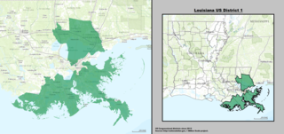
Louisiana's 1st congressional district is a congressional district in the U.S. state of Louisiana. The district comprises land from the northern shore of Lake Pontchartrain south to the Mississippi River delta. It covers most of New Orleans' suburbs, as well as a sliver of New Orleans itself.
Louisiana Highway 16 (LA 16) is a state highway located in southeastern Louisiana. It runs 110.27 miles (177.46 km) in a general east–west direction from LA 22 south of French Settlement to LA 21 in Sun.

Louisiana Highway 22 (LA 22) is a state highway located in southeastern Louisiana. It runs 71.15 miles (114.50 km) in a general east–west direction from the junction of LA 75 and LA 942 in Darrow to U.S. Highway 190 (US 190) in Mandeville.
Louisiana Highway 1077 (LA 1077) is a state highway located in southeastern Louisiana. It runs 20.61 miles (33.17 km) in a general north–south direction from a dead end at Lake Pontchartrain in Madisonville to a junction with LA 25 south of Folsom.
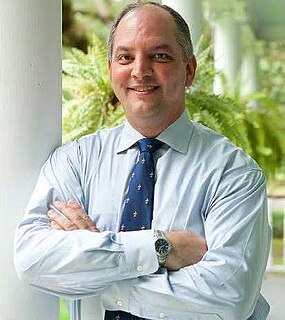
John Bel Edwards is an American politician and attorney serving as the 56th governor of Louisiana since 2016. A member of the Democratic Party, he previously served as the Democratic leader of the Louisiana House of Representatives for two terms.
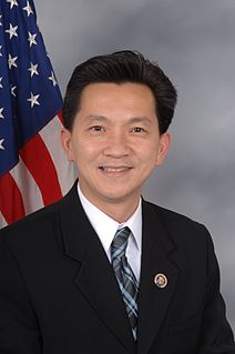
Ánh Quang "Joseph" Cao is a Vietnamese–American politician who was the U.S. representative for Louisiana's 2nd congressional district from 2009 to 2011. A member of the Republican Party, he is the first Vietnamese American and first native of Vietnam to serve in Congress.

Goodbee is an unincorporated community in Saint Tammany Parish, Louisiana, United States, at the intersection of U.S. Route 190 and Louisiana Highway 1077, west of Covington. Goodbee has a signed exit on Interstate 12 to its south, at its interchange with LA 1077.

Scott Anthony Angelle is an American politician who is the former director of the Bureau of Safety and Environmental Enforcement in Washington, D.C. From 2013 to 2017, he was the District 2 member of the Louisiana Public Service Commission, an elected five-person utility regulatory body.

The 1996 United States presidential election in Louisiana took place on November 5, 1996. Voters chose nine representatives, or electors to the Electoral College, who voted for president and vice president.
Louisiana Highway 40 (LA 40) is a state highway located in southeastern Louisiana. It runs 53.11 miles (85.47 km) in an east–west direction from LA 43 south of Montpelier to LA 41 in Bush.
Robert Weldon Russell III, known as Weldon Russell, is a Democrat and former member of the Louisiana House of Representatives who served from District 72 between 1984 and 1988 during the third administration of Governor Edwin Washington Edwards.
Mary Beth Sherman Mizell, is a businesswoman from Franklinton, Louisiana, who is a Republican member of the Louisiana State Senate for District 12, which encompasses the parishes of St. Tammany, Tangipahoa, and Washington, part of the Florida Parishes of southeastern Louisiana. On January 11, 2016, she succeeded the term-limited Democrat Ben Nevers.

Louisiana's 11th State Senate district is one of 39 districts in the Louisiana State Senate. It has been represented by Republican Patrick McMath since 2020.

Louisiana's 12th State Senate district is one of 39 districts in the Louisiana State Senate. It has been represented by Republican Beth Mizell since 2016.


