Natalbany, Louisiana | |
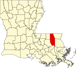
---|---|
Coordinates: 30°32′52″N90°29′02″W / 30.54778°N 90.48389°W | |
Country | United States |
State | Louisiana |
Parish | Tangipahoa |
Area | |
• Total | 4.47 sq mi (11.58 km2) |
• Land | 4.43 sq mi (11.46 km2) |
• Water | 0.04 sq mi (0.11 km2) |
Elevation | 49 ft (15 m) |
Population (2020) | |
• Total | 2,510 |
• Density | 567.10/sq mi (218.97/km2) |
Time zone | UTC-6 (CST) |
• Summer (DST) | UTC-5 (CDT) |
Area code | 985 |
FIPS code | 22-53475 |
Natalbany is a census-designated place (CDP) in Tangipahoa Parish, Louisiana, United States. The population was 1,739 at the 2000 census. It is part of the Hammond Micropolitan Statistical Area.
The community is named after the nearby Natalbany River. It is speculated that the name of the river is derived from the Choctaw words nita meaning bear and abani which means "to cook over a fire" in the Choctaw language. [2]
Natalbany is located at 30°32′52″N90°29′2″W / 30.54778°N 90.48389°W (30.547856, -90.483765). [3]
According to the United States Census Bureau, the CDP has a total area of 4.5 square miles (12 km2), of which 4.4 square miles (11 km2) is land and 0.1 square miles (0.26 km2) (1.56%) is water (including Ponchatoula Creek).
Census | Pop. | Note | %± |
---|---|---|---|
2020 | 2,510 | — | |
U.S. Decennial Census [4] |
Race | Number | Percentage |
---|---|---|
White (non-Hispanic) | 1,154 | 45.98% |
Black or African American (non-Hispanic) | 1,030 | 41.04% |
Native American | 13 | 0.52% |
Asian | 19 | 0.76% |
Other/Mixed | 81 | 3.23% |
Hispanic or Latino | 213 | 8.49% |
As of the 2020 United States census, there were 2,510 people, 1,130 households, and 553 families residing in the CDP.
At the 2000 census, [6] there were 1,739 people, 714 households and 411 families residing in the CDP. The population density was 393.1 inhabitants per square mile (151.8/km2). There were 814 housing units at an average density of 184.0 per square mile (71.0/km2). The racial makeup of the CDP was 67.74% White, 29.67% African American, 0.52% Native American, 0.23% Asian, 1.15% from other races, and 0.69% from two or more races. Hispanic or Latino of any race were 2.24% of the population.
There were 714 households, of which 31.8% had children under the age of 18 living with them, 38.0% were married couples living together, 16.7% had a female householder with no husband present, and 42.4% were non-families. 27.7% of all households were made up of individuals, and 6.6% had someone living alone who was 65 years of age or older. The average household size was 2.44 and the average family size was 3.06.
Age distribution was 26.0% under the age of 18, 22.1% from 18 to 24, 27.1% from 25 to 44, 15.5% from 45 to 64, and 9.4% who were 65 years of age or older. The median age was 26 years. For every 100 females, there were 82.9 males. For every 100 females age 18 and over, there were 83.3 males.
The median household income was $25,108, and the median family income was $29,120. Males had a median income of $25,938 versus $15,799 for females. The per capita income for the CDP was $12,815. About 17.4% of families and 25.0% of the population were below the poverty line, including 33.0% of those under age 18 and 27.3% of those age 65 or over.
Winston County is a county located in the U.S. state of Mississippi. In the 2020 census, the population was 17,714. Its county seat is Louisville. The county is named for Louis Winston (1784–1824), a colonel in the militia, a prominent lawyer, and a judge of the Mississippi Supreme Court.
McDonald Chapel is a census-designated place in Jefferson County, Alabama, United States. It is northeast of the Birmingham suburb of Pleasant Grove. At the 2020 census, the population was 739. Large portions of this area were damaged by violent tornadoes in 1956, 1998, and 2011. The 1998 tornado was rated F5 on the Fujita scale.
Lake Catherine is an unincorporated community and census-designated place (CDP) in Lake County, Illinois, United States. Per the 2020 census, the population was 1,279.
Albany is a town in eastern Livingston Parish, Louisiana, United States. The population was 1088 at the 2010 census. It is part of the Baton Rouge metropolitan statistical area.
Brownsville-Bawcomville is a former census-designated place (CDP) in Ouachita Parish, Louisiana, United States. The population was 7,616 at the 2000 census. It is part of the Monroe Metropolitan Statistical Area. For the 2010 census, the U.S. Census Bureau split Brownsville-Bawcomville into its two constituent communities, Brownsville and Bawcomville.
Lynchburg is an unincorporated area and census-designated place (CDP) in DeSoto County, Mississippi, United States. The population was 2,437 at the 2010 census.
Redwater is a census-designated place (CDP) in Leake County, Mississippi, United States. It is one of the eight communities of the Mississippi Band of Choctaw Indians Reservation, and the population is 61% Choctaw. The population was 633 at the 2010 census, up from 409 at the 2000 census.
Standing Pine is a census-designated place (CDP) in Leake County, Mississippi, United States. It is one of the eight communities of the Mississippi Band of Choctaw Indians Reservation, and the population is 94% Choctaw. The total population of the CDP was 517 at the 2020 census.
Pearl River is a census-designated place (CDP) in Neshoba County, Mississippi. It is one of the eight communities of the Mississippi Band of Choctaw Indians Reservation and the population is 80% Choctaw. The population was 3,156 at the 2000 census.
Tucker is a census-designated place (CDP) in Neshoba County, Mississippi. It is one of the eight communities of the Mississippi Band of Choctaw Indians Reservation and the population is 93% Choctaw. The population was 642 at the 2020 census.
Collinsville is an unincorporated community and census-designated place (CDP) in Lauderdale County, Mississippi, United States. The population was 1,984 at the 2020 census.
Conehatta is a census-designated place (CDP) in Newton County, Mississippi. The population was 997 at the 2000 census. It is one of the eight communities included in the Mississippi Band of Choctaw Indians Reservation and the population is 76% Choctaw.
Choctaw Lake is a census-designated place (CDP) in Madison County, Ohio, United States. The population was 1,562 at the 2000 census.
Longtown is a census-designated place (CDP) and unincorporated community in Pittsburg County, Oklahoma, United States. The population was 2,397 at the 2000 census.
Fort Duchesne is a census-designated place (CDP) in Uintah County, Utah, United States. The population was 714 at the 2010 census, an increase from the 2000 figure of 621.
Lochsloy is a census-designated place (CDP) in Snohomish County, Washington, United States. The population was 2,533 at the 2010 census.
MacArthur is a census-designated place (CDP) in Raleigh County, West Virginia, United States. Originally, it was named Hollywood and renamed MacArthur after General of the Army Douglas MacArthur in 1942. The population was 1,500 at the 2010 census.
Bogue Chitto is a census-designated place (CDP) situated in Kemper and Neshoba counties, Mississippi. The population was 864 at the 2020 census. It is part of the Mississippi Band of Choctaw Indians Reservation and the population is 93% Choctaw.
Barview is a census-designated place (CDP) in Coos County, Oregon, United States. The population was 1,844 at the 2010 census.
Thomaston is a census-designated place (CDP) comprising the main village in the town of Thomaston in Knox County, Maine, United States. The population was 1,875 at the 2010 census, out of 2,781 in the town of Thomaston as a whole.