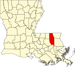
Osceola, Louisiana

Last updated

Osceola, Louisiana
USA Louisiana location map.svg
Red pog.svg
Osceola, Louisiana
Usa edcp location map.svg
Red pog.svg
Osceola, Louisiana
Coordinates: 30°39′03″N90°18′41″W / 30.65083°N 90.31139°W / 30.65083; -90.31139
Country United States
State Louisiana
Parish Tangipahoa
Elevation
102 ft (31 m)
Time zone UTC-6 (Central (CST))
  Summer (DST) UTC-5 (CDT)
Area code 985
GNIS feature ID555570 [1]
FIPS code 22-58325

Osceola is an unincorporated community in Tangipahoa Parish, Louisiana, United States. The community is located 16 miles (25.75 kilometres) NW of Covington, Louisiana.

Ella B. Hughes wrote that in 1888 a post office was built in Husser, Louisiana and just a few years later a second post office was built a few miles to the south and was called Viola. The area was renamed Osceola just a few years later. [2]

Etymology

The name of the community is derived from an ancient native american ritual dating back to the Archaic period. The Muscogee people would perform a ritual they called ássi which means black drink and yahola which means "shouting man" or "singer". There was also a very influential leader of the Seminole people from Florida named Osceola that was given this name. [3] [4]

Related Research Articles

<span class="mw-page-title-main">Interstate 12</span> Interstate in Louisiana

Interstate 12 (I-12) is an Interstate Highway located entirely within the US state of Louisiana. It spans a total of 85.59 miles (137.74 km) in an east–west direction from I-10 in Baton Rouge to an interchange with both I-10 and I-59 in Slidell. Along the way, it passes through the city of Hammond, where it intersects I-55 and US Route 51 (US 51). It also serves the cities of Ponchatoula and Denham Springs, as well as the St. Tammany Parish cities of Covington and Mandeville. Skirting the northern shore of Lake Pontchartrain, I-12 serves as both a northern bypass of the New Orleans metropolitan area and an alternate route for I-10, which serves the city of New Orleans itself.

<span class="mw-page-title-main">Washington Parish, Louisiana</span> Parish in Louisiana, United States

Washington Parish is a parish located in the interior southeast corner of the U.S. state of Louisiana, one of the Florida Parishes. As of the 2020 census, the population was 45,463. Its parish seat is Franklinton. Its largest city is Bogalusa. The parish was founded in 1819.

<span class="mw-page-title-main">Tangipahoa Parish, Louisiana</span> Parish in Louisiana, United States

Tangipahoa Parish is a parish located on the southeastern border of the U.S. state of Louisiana. As of the 2020 census, the population was 133,157. The parish seat is Amite City, while the largest city is Hammond. Southeastern Louisiana University is located in Hammond. Lake Pontchartrain borders the southeastern side of the parish.

<span class="mw-page-title-main">St. Tammany Parish, Louisiana</span> Parish in Louisiana, United States

St. Tammany Parish is a parish located in the U.S. state of Louisiana named after Tamanend, the legendary Lenape Chief of Chiefs and the "Patron Saint of America." At the 2020 census, the population was 264,570, making it the fourth-most populous parish in Louisiana. The parish seat is Covington. The parish was founded in 1810.

<span class="mw-page-title-main">Livingston Parish, Louisiana</span> Parish in Louisiana, United States

Livingston Parish is a parish in the U.S. state of Louisiana. Its parish seat is the town of Livingston. Livingston Parish is one of the Florida Parishes, a region which, unlike the rest of the state, was part of the Spanish Empire rather than the French Empire.

<span class="mw-page-title-main">LaPlace, Louisiana</span> Census-designated place in Louisiana, United States

LaPlace is a census-designated place (CDP) in St. John the Baptist Parish, Louisiana, United States, situated along the east bank of the Mississippi River, in the New Orleans metropolitan area. In 2020, it had a population of 28,841.

<span class="mw-page-title-main">Amite City, Louisiana</span> Town in Louisiana, United States

Amite City is a town in and the seat of Tangipahoa Parish in southeastern Louisiana, United States. The population was 4,141 at the 2010 census. It is part of the Hammond Micropolitan Statistical Area.

<span class="mw-page-title-main">Hammond, Louisiana</span> City in Louisiana, US

Hammond is the largest city in Tangipahoa Parish, Louisiana, United States, located 45 miles (72 km) east of Baton Rouge and 45 miles (72 km) northwest of New Orleans. Its population was 20,019 in the 2010 U.S. census, and 21,359 at the 2020 population estimates program.

<span class="mw-page-title-main">Independence, Louisiana</span> Town in Louisiana, United States

Independence, originally known as Uncle Sam, is a town in Tangipahoa Parish, Louisiana, United States. The population was 1,665 at the 2010 census. It is part of the Hammond Micropolitan Statistical Area.

<span class="mw-page-title-main">Manchac, Louisiana</span> Unincorporated community in Louisiana, United States

Manchac is an unincorporated community in Tangipahoa Parish, Louisiana, United States.

<span class="mw-page-title-main">Louisiana Highway 445</span>

Louisiana Highway 445 is a state highway in Louisiana that serves Tangipahoa Parish. It spans 24.6 miles (39.6 km) in a south to north direction. Near its north end, it is known as Husser Road.

<span class="mw-page-title-main">U.S. Route 51 in Louisiana</span>

U.S. Highway 51 (US 51) is a part of the United States Numbered Highway System that spans 1,277 miles (2,055 km) from LaPlace, Louisiana to a point north of Hurley, Wisconsin. Within the state of Louisiana, the highway travels 69.12 miles (111.24 km) from the national southern terminus at US 61 in LaPlace to the Mississippi state line north of Kentwood.

<span class="mw-page-title-main">Louisiana Highway 40</span>

Louisiana Highway 40 (LA 40) is a state highway located in southeastern Louisiana. It runs 53.11 miles (85.47 km) in an east–west direction from LA 43 south of Montpelier to LA 41 in Bush.

<span class="mw-page-title-main">Harry Wilson (politician)</span> American politician

Harry D. Wilson was a Democratic politician from Tangipahoa Parish, one of the Florida Parishes of southeastern Louisiana, who served from 1916 until his death as the Louisiana Commissioner of Agriculture and Forestry. He was the father of the humorist and chef Justin E. Wilson.

Husser is an unincorporated community in Tangipahoa Parish, Louisiana, United States. Its ZIP code is 70442.

Uneedus is an unincorporated community in Tangipahoa Parish, in the U.S. state of Louisiana.

Bedico is an unincorporated community in Tangipahoa Parish, Louisiana, United States. Bedico is located on Highway 22, 13 mi (20.92 km) miles east of Hammond.

Kirkville is an unincorporated community in Tangipahoa Parish, Louisiana, United States. The community is located 1 mile S of Osyka, Mississippi and 18 miles N of Amite City, Louisiana

Lees Landing is an unincorporated community in Tangipahoa Parish, Louisiana, United States. The community is located 7 miles SE of Ponchatoula, Louisiana.

References

  1. U.S. Geological Survey Geographic Names Information System: Osceola, Louisiana
  2. "Husser Happenings of Long ago, Tangipahoa Parish, LA". USGenWeb Archives. Retrieved August 24, 2019.
  3. Joy Wallace Dickinson. "That's some cup of tea". Orlando Sentinel. Retrieved August 23, 2019.
  4. "Osceola: Seminole Warrior". National Park Service. Retrieved August 23, 2019.