Kentwood, Louisiana

Last updated

Kentwood, Louisiana
Town of Kentwood
2015-05-07 Kentwood Day of Prayer landscape DSC 0216.jpg
Kentwood residents observe a noontide Day of Prayer in front of the Town Hall in 2015
Motto: 
"The Foyer of Louisiana"
Tangipahoa Parish Louisiana Incorporated and Unincorporated areas Kentwood Highlighted.svg
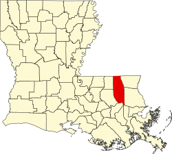
Location of Kentwood in Tangipahoa Parish, Louisiana.
Louisiana in United States (US48).svg
Location of Louisiana in the United States
Coordinates: 30°55′50″N90°30′25″W / 30.93056°N 90.50694°W / 30.93056; -90.50694 [1]
CountryUnited States
StateLouisiana
Parish Tangipahoa
Founded1893
Area
[2]
  Total7.11 sq mi (18.42 km2)
  Land7.11 sq mi (18.42 km2)
  Water0.00 sq mi (0.01 km2)
Elevation
[1]
223 ft (68 m)
Population
 (2020)
  Total2,145
  Density301.69/sq mi (116.48/km2)
Time zone UTC−06:00 (CST)
  Summer (DST) UTC−05:00 (CDT)
ZIP code
70444 [3]
Area code 985
FIPS code 22-39545
GNIS feature ID2405939 [1]

Kentwood is a rural town in Tangipahoa Parish, Louisiana, United States, near the Mississippi state line. The population was 2,198 at the 2010 census. It is part of the Hammond Micropolitan Statistical Area. Kentwood is best known as the hometown of singer Britney Spears.
Contents

History

Amos Kent assisted in laying out the town. The Postmaster named the town in honor of Kent on February 29, 1888. [4]

On August 30, 2012, damage was caused by pressure on the 2,300 foot Percy Quin dam, a dam on the Tangipahoa River north of Kentwood, as a result of Hurricane Isaac, led to Louisiana Governor Bobby Jindal calling for a mandatory evacuation of the town due to fears of large-scale flooding from Lake Tangipahoa. The evacuation order, which was amended twice, was later rescinded as the dam held. The lake was drawn down so repairs could be made. [5]

The 490-acre Lake Tangipahoa, which opened in 1939 and is located six miles south of McComb, Mississippi, was reopened in 2016. Repairs had been completed in 2014 and the lake restocked. [6]

Geography

According to the United States Census Bureau, the town has a total area of 6.9 square miles (18 km2), of which 6.9 square miles (18 km2) is land and 0.14% is water.

Demographics

Historical population
CensusPop.Note
1900 1,313
1910 3,609174.9%
1920 3,059−15.2%
1930 1,726−43.6%
1940 1,8547.4%
1950 2,41730.4%
1960 2,6077.9%
1970 2,7364.9%
1980 2,667−2.5%
1990 2,468−7.5%
2000 2,205−10.7%
2010 2,198−0.3%
2020 2,145−2.4%
U.S. Decennial Census [7]

2020 census

Kentwood racial composition [8]
RaceNumberPercentage
White (non-Hispanic)41419.3%
Black or African American (non-Hispanic)1,64276.55%
Native American 10.05%
Asian 40.19%
Other/Mixed 602.8%
Hispanic or Latino 241.12%

As of the 2020 United States census, there were 2,145 people, 771 households, and 421 families residing in the town.

2000 census

At the 2000 census there were 2,205 people, 850 households, and 559 families in the town. The population density was 318.4 inhabitants per square mile (122.9/km2). There were 979 housing units at an average density of 141.4 per square mile (54.6/km2). The racial makeup of the town was 64.85% African American, 34.42% White, 0.09% Native American, 0.09% Asian, 0.14% from other races, and 0.41% from two or more races. Hispanic or Latino residents of any race were 0.68%. [9]

Of the 850 households, 30.7% had children under the age of 18 living with them, 32.6% were married couples living together, 28.2% had a female householder with no husband present, and 34.2% were non-families. 29.9% of households were one person and 15.8% were one person aged 65 or older. The average household size was 2.59 and the average family size was 3.28.

The age distribution was 29.9% under the age of 18, 11.5% from 18 to 24, 23.5% from 25 to 44, 20.4% from 45 to 64, and 14.7% 65 or older. The median age was 34 years. For every 100 females, there were 80.1 males. For every 100 females age 18 and over, there were 73.7 males.

The median household income was $17,297 and the median family income was $23,889. Males had a median income of $25,583 versus $15,200 for females. The per capita income for the town was $11,171. About 29.5% of families and 37.6% of the population were below the poverty line, including 49.2% of those under age 18 and 32.5% of those age 65 or over.

Education

Tangipahoa Parish School Board operates public schools:

Notable people

See also

Related Research Articles

<span class="mw-page-title-main">Loudon County, Tennessee</span> County in Tennessee, United States

Loudon County is a county in the U.S. state of Tennessee. It is located in the central part of East Tennessee. As of the 2020 census, the population was 54,886. Its county seat is Loudon. Loudon County is included in the Knoxville, TN Metropolitan Statistical Area.

<span class="mw-page-title-main">Tangipahoa Parish, Louisiana</span> Parish in Louisiana, United States

Tangipahoa Parish is a parish located on the southeastern border of the U.S. state of Louisiana. As of the 2020 census, the population was 133,157. The parish seat is Amite City, while the largest city is Hammond. Southeastern Louisiana University is located in Hammond. Lake Pontchartrain borders the southeastern side of the parish.

<span class="mw-page-title-main">Hamilton, Illinois</span> Place in Illinois, United States

Hamilton is a city in Hancock County, Illinois, United States. The population was 2,753 at the 2020 census, a decline from 2,951 in 2010. The city is located directly across the Mississippi River from Keokuk, Iowa. Hamilton is the largest city in Hancock County.

Moss Bluff is a census-designated place (CDP) in Calcasieu Parish, Louisiana, United States. The population was 12,522 at the 2020 census. Located just north of the city of Lake Charles, it is considered a suburb of that city. Moss Bluff is a burgeoning community, and is one of the communities in Calcasieu Parish besides Lake Charles and Sulphur experiencing growth. Several efforts have been made to incorporate Moss Bluff, but at the present time the community is unincorporated.

<span class="mw-page-title-main">Springfield, Louisiana</span> Town in Louisiana, United States

Springfield is a town in Livingston Parish, Louisiana, United States. The population was 487 at the 2010 census. It is part of the Baton Rouge metropolitan statistical area.

<span class="mw-page-title-main">Covington, Louisiana</span> City in Louisiana, United States

Covington is a city in, and the parish seat of, St. Tammany Parish, Louisiana, United States. The population was 11,564 at the 2020 United States census. It is located at a fork of the Bogue Falaya and the Tchefuncte River. Covington is part of the Slidell-Mandeville-Covington, LA metropolitan statistical area. Covington has played a large role in movie making over the past 20 years, featuring in over 30 films.

<span class="mw-page-title-main">Amite City, Louisiana</span> Town in Louisiana, United States

Amite City is a town in and the seat of Tangipahoa Parish in southeastern Louisiana, United States. The population was 4,141 at the 2010 census. It is part of the Hammond Micropolitan Statistical Area.

<span class="mw-page-title-main">Independence, Louisiana</span> Town in Louisiana, United States

Independence, originally known as Uncle Sam, is a town in Tangipahoa Parish, Louisiana, United States. The population was 1,665 at the 2010 census. It is part of the Hammond Micropolitan Statistical Area.

<span class="mw-page-title-main">Natalbany, Louisiana</span> CDP in Louisiana, United States

Natalbany is a census-designated place (CDP) in Tangipahoa Parish, Louisiana, United States. The population was 1,739 at the 2000 census. It is part of the Hammond Micropolitan Statistical Area.

<span class="mw-page-title-main">Ponchatoula, Louisiana</span> City in Louisiana

Ponchatoula is the second-largest city in Tangipahoa Parish, Louisiana. The population was 6,559 at the 2010 census and 7,545 at the time of the 2020 population estimates program.

<span class="mw-page-title-main">Roseland, Louisiana</span> Town in Louisiana, United States

Roseland is a town in Tangipahoa Parish, Louisiana, United States. The population was 1,123 at the 2010 census. It is the birthplace of Cajun chef and storyteller Justin Wilson.

<span class="mw-page-title-main">Tangipahoa, Louisiana</span> Village in Louisiana

Tangipahoa is a village in Tangipahoa Parish, Louisiana, United States. The population was 425 at the 2020 census. It was named after the Tangipahoa Native American tribe. Tangipahoa is part of the Hammond Micropolitan Statistical Area.

<span class="mw-page-title-main">Tickfaw, Louisiana</span> Village in Louisiana, United States

Tickfaw was founded in 1852 and is a village in Tangipahoa Parish, Louisiana, United States. The population was 694 at the 2010 census. Tickfaw is part of the Hammond Micropolitan Statistical Area. It was originally inhabited by Italian-American immigrants and continues to have a distinct Italian-American heritage.

<span class="mw-page-title-main">Mount Vernon, Maine</span> Town in the state of Maine, United States

Mount Vernon is a town in Kennebec County, Maine, United States. The population was 1,721 at the 2020 census. Mount Vernon is included in the Augusta, Maine micropolitan New England City and Town Area. A popular recreation spot in central Maine, the northern area of Mount Vernon is part of the Belgrade Lakes Region, while the southern area is part of the Winthrop Lakes Region.

<span class="mw-page-title-main">Caledonia, Michigan</span> Village in Michigan, United States

Caledonia is a village in Kent County in the U.S. state of Michigan. The population was 1,622 at the 2020 census. The village is located within Caledonia Township about 15 miles (24.1 km) southeast of downtown Grand Rapids.

<span class="mw-page-title-main">Kentwood, Michigan</span> City in Michigan, United States

Kentwood is a city in Kent County in the U.S. state of Michigan. The population was 54,304 as of the 2020 census. The city is bordered on the northwest by Grand Rapids and is the third most-populated municipality in the Grand Rapids metropolitan area.

<span class="mw-page-title-main">Weare, New Hampshire</span> Town in New Hampshire, United States

Weare is a town in Hillsborough County, New Hampshire, United States. The population was 9,092 at the 2020 census. It is close to two important New Hampshire cities, Manchester and Concord.

<span class="mw-page-title-main">Muldrow, Oklahoma</span> Town in Oklahoma, United States

Muldrow, officially the Town of Muldrow, is a town in Sequoyah County, Oklahoma, United States. It is part of the Fort Smith, Arkansas–Oklahoma Metropolitan Statistical Area. The population was 3,466 at the 2010 census, an increase of 11.7 percent over the figure of 3,104 recorded in 2000.

<span class="mw-page-title-main">Oakland, Douglas County, Wisconsin</span> Town in Wisconsin, United States

Oakland is a town in Douglas County, Wisconsin, United States. The population was 1,144 at the 2000 census.

<span class="mw-page-title-main">Beaver Dam (town), Wisconsin</span> Town in Wisconsin, United States

Beaver Dam is a town in Dodge County, Wisconsin, United States. The population was 4,062 at the 2020 census. The City of Beaver Dam is encircled by the town. The unincorporated communities of Beaver Edge, Leipsig and Sunset Beach are located in the town. The ghost town of Clason Prairie was also located in the town.

References

  1. 1 2 3 U.S. Geological Survey Geographic Names Information System: Kentwood, Louisiana
  2. "2020 U.S. Gazetteer Files". United States Census Bureau. Retrieved March 20, 2022.
  3. "Kentwood LA ZIP Code". zipdatamaps.com. 2023. Retrieved June 16, 2023.
  4. "Kentwood History" . Retrieved July 7, 2024.
  5. "Percy Quin's Lake Tangipahoa drained after Tropical Storm Isaac" . Retrieved July 7, 2024.
  6. "Lake Tangipahoa (Percy Quin State Park)" . Retrieved July 7, 2024.
  7. "Census of Population and Housing". Census.gov. Retrieved June 4, 2015.
  8. "Explore Census Data". data.census.gov. Retrieved December 28, 2021.
  9. "U.S. Census website". United States Census Bureau . Retrieved January 31, 2008.