Varnado, Louisiana

Last updated

Varnado, Louisiana
Village
Washington Parish Louisiana Incorporated and Unincorporated areas Varnado Highlighted.svg
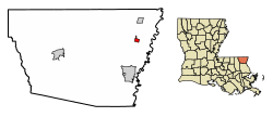
Location of Varnado in Washington Parish, Louisiana.
Louisiana in United States (US48).svg
Location of Louisiana in the United States
Coordinates: 30°53′42″N89°49′54″W / 30.89500°N 89.83167°W / 30.89500; -89.83167
CountryUnited States
StateLouisiana
Parish Washington
Area
[1]
  Total
0.85 sq mi (2.20 km2)
  Land0.85 sq mi (2.20 km2)
  Water0.00 sq mi (0.00 km2)
Elevation
128 ft (39 m)
Population
 (2020)
  Total
330
  Density388.69/sq mi (150.13/km2)
Time zone UTC-6 (CST)
  Summer (DST) UTC-5 (CDT)
Zip Code
70467
Area code 985
FIPS code 22-77910

Varnado is a village in Washington Parish, Louisiana, United States. The population was 1,461 at the 2010 census. It is part of the Bogalusa Micropolitan Statistical Area.

Contents

Geography

Varnado is located at 30°53′42″N89°49′54″W / 30.89500°N 89.83167°W / 30.89500; -89.83167 (30.894911, -89.831635). [2]

According to the United States Census Bureau, the village has a total area of 0.9 square miles (2.3 km2), all land.

Demographics

Historical population
CensusPop.Note
1920 275
1930 204−25.8%
1940 31554.4%
1950 306−2.9%
1960 3318.2%
1970 320−3.3%
1980 249−22.2%
1990 236−5.2%
2000 34244.9%
2010 1,461327.2%
2020 330−77.4%
U.S. Decennial Census [3]

As of the census [4] of 2000, there were 342 people, 144 households, and 86 families residing in the village. The population density was 402.9 inhabitants per square mile (155.6/km2). There were 163 housing units at an average density of 192.0 per square mile (74.1/km2). The racial makeup of the village was 88.60% White, 9.36% African American, 0.58% Native American, and 1.46% from two or more races.

There were 144 households, out of which 27.1% had children under the age of 18 living with them, 41.0% were married couples living together, 16.7% had a female householder with no husband present, and 39.6% were non-families. 34.7% of all households were made up of individuals, and 13.2% had someone living alone who was 65 years of age or older. The average household size was 2.38 and the average family size was 3.15.

In the village, the population was spread out, with 24.9% under the age of 18, 12.0% from 18 to 24, 26.9% from 25 to 44, 22.8% from 45 to 64, and 13.5% who were 65 years of age or older. The median age was 38 years. For every 100 females, there were 74.5 males. For every 100 females age 18 and over, there were 73.6 males.

The median income for a household in the village was $26,563, and the median income for a family was $30,909. Males had a median income of $30,938 versus $21,000 for females. The per capita income for the village was $14,416. About 21.4% of families and 19.5% of the population were below the poverty line, including 23.4% of those under age 18 and 9.1% of those age 65 or over.

Notable people

Related Research Articles

<span class="mw-page-title-main">Hooppole, Illinois</span> Village in Illinois, United States

Hooppole is a village in Henry County, Illinois, United States. The population was 180 at the 2020 census.

<span class="mw-page-title-main">Wataga, Illinois</span> Village in Illinois, United States

Wataga is a village in Knox County, Illinois, United States. The population was 843 at the 2010 census, down from 857 in 2000. It is part of the Galesburg Micropolitan Statistical Area.

<span class="mw-page-title-main">Percy, Illinois</span> Village in Illinois, United States

Percy is a village in Randolph County, Illinois, United States. The population was 970 at the 2010 census.

<span class="mw-page-title-main">Sunfield, Michigan</span> Village in Michigan, United States

Sunfield is a village in Eaton County in the U.S. state of Michigan. The population was 518 at the 2020 U.S. Census. The village is located within Sunfield Township.

<span class="mw-page-title-main">Mattawan, Michigan</span> Village in Michigan, United States

Mattawan is a village in Antwerp Township, Van Buren County of the U.S. state of Michigan. The population was 1,997 at the 2010 census.

<span class="mw-page-title-main">Big Lake, Missouri</span> Village in Missouri, United States

Big Lake is a village in Holt County, Missouri, United States. The population was 65 at the 2020 census.

<span class="mw-page-title-main">Cobalt, Missouri</span> Village in Missouri, United States

Cobalt is a village in Madison County, Missouri, United States. As of the 2020 census, the population was 264, up from 226 in 2010.

<span class="mw-page-title-main">Whispering Pines, North Carolina</span> Village in North Carolina, United States

Whispering Pines is a village in Moore County, North Carolina, United States. The population was 2,928 at the 2010 census.

<span class="mw-page-title-main">Clarksville, Ohio</span> Village in Ohio, United States

Clarksville is a village in Clinton County, Ohio, United States. The population was 534 at the 2020 census. It is served by the Clinton Massie branch of the Wilmington Public Library of Clinton County.

<span class="mw-page-title-main">Vinton, Ohio</span> Village in Ohio, United States

Vinton is a village in Gallia County, Ohio, United States. The population was 224 at the 2020 census. It is part of the rural Point Pleasant micropolitan area.

<span class="mw-page-title-main">Addyston, Ohio</span> Village in Ohio, United States

Addyston is a village in Miami Township, Hamilton County, Ohio, United States. Located along the Ohio River, it is a western suburb of the neighboring city of Cincinnati. The population was 927 at the 2020 census.

<span class="mw-page-title-main">Antioch, Ohio</span> Village in Ohio, United States

Antioch is a village in Monroe County, Ohio, United States. The population was 71 at the 2020 census.

<span class="mw-page-title-main">Harmar Township, Allegheny County, Pennsylvania</span> Township in Pennsylvania, United States

Harmar Township is a township in Allegheny County, Pennsylvania, United States. It contains the communities of Acmetonia, Harmarville, Harmar Heights, and Chapel Downs. The population was 3,136 at the 2020 census. The township was named after Harmar Denny, a U.S. congressman and son of Ebenezer Denny.

<span class="mw-page-title-main">Friesland, Wisconsin</span> Village in Wisconsin, United States

Friesland is a village in Columbia County, Wisconsin, United States. The population was 320 at the 2020 census. It is part of the Madison Metropolitan Statistical Area, and was named after Friesland, one of the twelve provinces of the Netherlands.

<span class="mw-page-title-main">Mount Sterling, Wisconsin</span> Village in Wisconsin, United States

Mount Sterling is a village in Crawford County, Wisconsin, United States. The population was 189 at the 2020 census.

<span class="mw-page-title-main">Rockdale, Wisconsin</span> Village in Wisconsin, United States

Rockdale is a village in Dane County, Wisconsin, United States. The population was 207 at the 2020 census, making it the smallest incorporated municipality in Dane County. The village is split in half by the Koshkonong Creek. It is part of the Madison Metropolitan Statistical Area.

<span class="mw-page-title-main">Orfordville, Wisconsin</span> Village in Wisconsin, United States

Orfordville is a village in Rock County, Wisconsin, United States. It is located at the intersection of Highway 11, Highway 213, and the Wisconsin and Southern Railroad. The population was 1,473 at the 2020 census.

Hartrandt is a census-designated place (CDP) in Natrona County, Wyoming, United States. It is part of the Casper, Wyoming Metropolitan Statistical Area and the population was 693 at the 2010 census.

Washburn is a town in Bayfield County, Wisconsin, United States. The population was 554 at the 2020 census, up from 530 at the 2010 census. The City of Washburn is located just east of and adjacent to the town.

<span class="mw-page-title-main">Aniwa (town), Wisconsin</span>

Aniwa is a town in Shawano County, Wisconsin, United States. The population was 586 at the 2000 census. The Village of Aniwa is located within the town.

References

  1. "2020 U.S. Gazetteer Files". United States Census Bureau. Retrieved March 20, 2022.
  2. "US Gazetteer files: 2010, 2000, and 1990". United States Census Bureau. February 12, 2011. Retrieved April 23, 2011.
  3. "Census of Population and Housing". Census.gov. Retrieved June 4, 2015.
  4. "U.S. Census website". United States Census Bureau . Retrieved January 31, 2008.
  5. Brugler, Dane. "The Beast: 2023 NFL Draft Guide" (PDF). The Athletic . p. 188. Retrieved April 10, 2022.