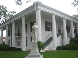
Claiborne Parish, Louisiana Last updated December 21, 2025 History John Murrell moved his family from Arkansas to the Flat Lick Bayou area about 6 miles west of present-day Homer in 1818, and they became the first known non-natives to permanently settle in Claiborne Parish. As more settlers moved into the area, the Murrell house served as a church, school and post office. When the state legislature created Claiborne Parish out of Natchitoches Parish in 1828, all governmental business, including court, began being held in the Murrell house. This continued until the new parish's police jury selected Russellville (now a ghost town located northeast of Athens ) as the parish seat. [ 4] [ 5] [ 6] As the population began swelling in what was then the western part of the parish, the seat was moved to Overton (another modern ghost town found near Minden ) in 1836, because of its position at the head of the navigable portion of Dorcheat Bayou. Due to flooding and health concerns, the parish seat was moved to Athens in 1846, but an 1848 fire destroyed the courthouse and all the records in it. Soon thereafter the Claiborne Police Jury chose the present site for the parish seat, which came to be named, Homer. [ 7] [ 8]
Much of the area history is preserved in the Herbert S. Ford Memorial Museum , located across from the parish courthouse in Homer.[ citation needed ]
Geography According to the U.S. Census Bureau , the parish has a total area of 767 square miles (1,990 km 2 ) , of which 755 square miles (1,960 km 2 ) is land and 13 square miles (34 km 2 ) (1.6%) is water. [ 11]
Communities Unincorporated communities Demographics Historical population Census Pop. Note %± 1830 1,764 — 1840 6,185 250.6% 1850 7,471 20.8% 1860 16,848 125.5% 1870 20,240 20.1% 1880 18,837 −6.9% 1890 23,312 23.8% 1900 23,029 −1.2% 1910 25,050 8.8% 1920 27,885 11.3% 1930 32,285 15.8% 1940 29,855 −7.5% 1950 25,063 −16.1% 1960 19,407 −22.6% 1970 17,024 −12.3% 1980 17,095 0.4% 1990 17,405 1.8% 2000 16,851 −3.2% 2010 17,195 2.0% 2020 14,170 −17.6% 2024 (est.) 13,537 [ 12] −4.5%
2020 census Claiborne Parish, Louisiana – Racial and ethnic composition Note: the US Census treats Hispanic/Latino as an ethnic category. This table excludes Latinos from the racial categories and assigns them to a separate category. Hispanics/Latinos may be of any race. Race / Ethnicity (NH = Non-Hispanic ) Pop 1980 [ 17] Pop 1990 [ 18] Pop 2000 [ 19] Pop 2010 [ 20] Pop 2020 [ 21] % 1980 % 1990 % 2000 % 2010 % 2020 White alone (NH) 9,032 9,300 8,679 8,084 7,064 52.83% 53.43% 51.50% 47.01% 49.85% Black or African American alone (NH) 7,851 8,022 7,925 8,707 6,138 45.93% 46.09% 47.03% 50.64% 43.32% Native American or Alaska Native alone (NH) 2 28 24 59 43 0.01% 0.16% 0.14% 0.34% 0.30% Asian alone (NH) 10 13 14 39 42 0.06% 0.07% 0.08% 0.23% 0.30% Native Hawaiian or Pacific Islander alone (NH) x [ 22] x [ 23] 2 1 0 x x 0.01% 0.01% 0.00% Other race alone (NH) 13 2 2 2 21 0.08% 0.01% 0.01% 0.01% 0.15% Mixed race or Multiracial (NH) x [ 24] x [ 25] 77 132 383 x x 0.46% 0.77% 2.70% Hispanic or Latino (any race) 187 40 128 171 479 1.09% 0.23% 0.76% 0.99% 3.38% Total 17,095 17,405 16,851 17,195 14,170 100.00% 100.00% 100.00% 100.00% 100.00%
As of the 2020 United States census , there were 14,170 people, 5,917 households, and 3,718 families residing in the parish. [ 26]
Politics With a narrow majority of African Americans in the population, Claiborne Parish in the years after the civil rights movement was primarily Democratic in political complexion. In 1988 , Vice President George Herbert Walker Bush prevailed in Claiborne Parish with 3,756 votes (53.6 percent). Governor Michael S. Dukakis of Massachusetts trailed with 3,158 votes (45.1 percent). [ 27] In 1996 , U.S. President Bill Clinton of neighboring Arkansas , obtained 3,609 votes (53.6 percent) in Claiborne Parish. Republican Bob Dole of Kansas polled 2,500 votes (37.1 percent). [ 28]
However, by 2008, U.S. Senator John McCain of Arizona easily carried the parish in his losing race to Barack Obama . McCain polled 3,750 votes (54.8 percent) to Obama's 3,025 votes (44.2 percent). [ 29] In 2012, Mitt Romney carried the parish, with 3,649 votes (54.2 percent), nearly identical to the McCain tally four years earlier. President Obama received 3,014 votes (44.8 percent), or .6 of 1 percent greater than his earlier tabulation. [ 30]
Notable people Prominent Claiborne Parish residents include or have included:
Henry Walton Bibb American author, abolitionist, and former slave from 1839 to 1841 [ 34] T. H. Harris , state education superintendent from 1908 to 1940. [ 35] Andrew R. Johnson was a state senator from Claiborne and Bienville parishes from 1916 to 1924. [ 36] John Sidney Killen , state representative for Claiborne Parish in 1871 [ 37] Joe LeSage , state senator for Caddo Parish from 1968 to 1972; Shreveport attorney born in Homer [ 38] George H. Mahon , Former U.S. Representative. [ 39] James T. McCalman , state senator from Claiborne and Bienville parishes from 1960 to 1964. [ 40] Danny Roy Moore , state senator from 1964 to 1968. [ 41] Dave L. Pearce , Louisiana Commissioner of Agriculture and Forestry from 1952 to 1956 and 1960–1976. [ 42] Larry Sale , sheriff of Claiborne Parish from 1936 to 1944; bodyguard at the assassination of Huey Pierce Long Jr. [ 43] Richard Stalder , former secretary of the Louisiana Department of Public Safety and Corrections . David Wade , Lieutenant General of the United States Air Force . [ 44] Loy F. Weaver , state representative from 1976 to 1984. [ 45] Mule Watson , pitcher in Major League Baseball from 1918 to 1924. [ 46] Pinkie C. Wilkerson state representative from 1992 to 2000. [ 47] Patrick Floyd Garrett , Sheriff of Lincoln County New Mexico, and killer of Billy the Kid. [ 48] References ↑ Harris, D. W.; Hulse, B. M. (1886). The History of Claiborne Parish, Louisiana . Retrieved September 3, 2014 . 1 2 "QuickFacts Caliborne Parish, Louisiana" . United States Census Bureau. Retrieved September 7, 2022 . ↑ "Find a County" . National Association of Counties. Archived from the original on May 31, 2011. Retrieved June 7, 2011 . ↑ Burr, Murphy J. "Murrell family pioneered in Claiborne Parish" . www.thepineywoods.com/ . The Piney Woods Journal. Archived from the original on March 4, 2016. Retrieved December 14, 2014 . ↑ Volentine, Linda; Herring, Susan T. "Bridges Mill School Remembered" . The Guardian-Journal. Retrieved December 15, 2014 . ↑ Herring, Susan T. (April 29, 1999). " . www.usgwarchives.net/ . The Guardian-Journal. Retrieved December 15, 2014 . ↑ Harris, D. W.; Hulse, B. M., eds. (1886). The History of Claiborne Parish, Louisiana, From Its Incorporation in 1828 to the Close of the Year 1885 19 –20, 103. ↑ "Russellville: Ghost Town of Claiborne Parish " . claiborneone.org. Archived from the original on July 7, 2010. Retrieved July 8, 2010 . ↑ "David Wade Corr. Center Archived 2011-01-27 at the Wayback Machine Louisiana Department of Public Safety and Corrections . Accessed September 14, 2008. ↑ "Inmate wants his privileges restored ." The Advocate . January 11, 1990. Retrieved on October 2, 2010. "But Mule was transferred to Wade Correctional Center in Haynesville[...]" ↑ "2010 Census Gazetteer Files" . United States Census Bureau. August 22, 2012. Archived from the original on September 28, 2013. Retrieved August 27, 2014 . ↑ "County Population Totals and Components of Change: 2020-2024" . United States Census Bureau. Retrieved August 29, 2025 . ↑ "U.S. Decennial Census" . United States Census Bureau. Retrieved August 27, 2014 . ↑ "Historical Census Browser" . University of Virginia Library. Archived from the original on August 11, 2012. Retrieved August 27, 2014 . ↑ "Population of Counties by Decennial Census: 1900 to 1990" . United States Census Bureau. Retrieved August 27, 2014 . ↑ "Census 2000 PHC-T-4. Ranking Tables for Counties: 1990 and 2000" (PDF) . United States Census Bureau. Archived (PDF) from the original on March 27, 2010. Retrieved August 27, 2014 . ↑ "1980 Census of Population - General Population Characteristics - Louisiana - Table 14 - Persons by Race and Table 15 - Total Persons and Spanish Origin Persons by Type of Spanish Origin and Race (p. 20/12-20/20)" (PDF) . United States Census Bureau . ↑ "1990 Census of Population - General Population Characteristics - Louisiana - Table 6 - Race and Hispanic Origin" (PDF) . United States Census Bureau . p. 15-38. ↑ "P004: Hispanic or Latino, and Not Hispanic or Latino by Race – 2000: DEC Summary File 1 – Claiborne Parish, Louisiana" . United States Census Bureau . ↑ "P2: Hispanic or Latino, and Not Hispanic or Latino by Race – 2010: DEC Redistricting Data (PL 94-171) – Claiborne Parish, Louisiana" . United States Census Bureau . ↑ "P2: Hispanic or Latino, and Not Hispanic or Latino by Race – 2020: DEC Redistricting Data (PL 94-171) – Claiborne Parish, Louisiana" . United States Census Bureau . ↑ included in the Asian category in the 1980 Census ↑ included in the Asian category in the 1990 Census ↑ not an option in the 1980 Census ↑ not an option in the 1990 Census ↑ "Explore Census Data" . data.census.gov . Retrieved December 29, 2021 . ↑ "Claiborne Parish presidential election returns, November 8, 1988" . staticresults.sos.la.gov. Retrieved November 11, 2012 . ↑ "Claiborne Parish presidential election returns, November 5, 1996" . staticresults.sos.la.gov. Retrieved November 11, 2012 . ↑ "Claiborne Parish presidential election returns" . staticresults.sos.la.gov. Retrieved November 11, 2012 . ↑ "Claiborne Parish presidential election returns, November 6, 2012" . staticresults.sos.la.gov. Retrieved November 11, 2012 . ↑ Leip, David. "Dave Leip's Atlas of U.S. Presidential Elections" . uselectionatlas.org . Retrieved March 7, 2018 . ↑ "2020 CENSUS - SCHOOL DISTRICT REFERENCE MAP: Claiborne Parish, LA" (PDF) . U.S. Census Bureau . Retrieved February 11, 2024 . Text list ↑ "image007.gif Archived 2011-06-27 at the Wayback Machine Claiborne Academy . Retrieved on October 2, 2010. "6741 Highway 19, Haynesville, LA 71038." ↑ Bibb, Henry (1849). Narrative of the Life and Adventures of Henry Bibb, An American Slave, Written by Himself ↑ "T H Harris 1925 bio - Claiborne LAGenWeb" . www.lagenweb.org . Retrieved April 19, 2024 . ↑ "Andrew R Johnson 1925 bio - Claiborne LAGenWeb" . www.lagenweb.org . Retrieved April 19, 2024 . ↑ "John Killen Home" . Minden Memories. Archived from the original on July 18, 2011. Retrieved March 16, 2015 . ↑ "Joe C. LeSage, Jr., obituary" . The Shreveport Times . September 24, 2015. Retrieved September 27, 2015 . ↑ "Congressman George Mahon Historical Marker" . www.hmdb.org . Retrieved April 19, 2024 . ↑ "Membership in the Louisiana Senate, 1880-2024" (PDF) . senate.louisiana.gov. Retrieved April 19, 2024 . ↑ "Membership in the Louisiana Senate, 1880-2024" (PDF) . senate.louisiana.gov. Retrieved April 19, 2024 . ↑ "Lake Charles American-Press from Lake Charles, Louisiana" . Newspapers.com . December 15, 1965. Retrieved April 19, 2024 . ↑ Exhibit, Herbert S. Ford Memorial Museum, Homer, Louisiana ↑ Wade Room, Herbert S. Ford Memorial Museum, Homer, Louisiana ↑ "Membership in the Louisiana House of Representatives, 1812-2012" (PDF) . house.louisiana.gov. Archived from the original (PDF) on March 31, 2010. Retrieved September 5, 2009 . ↑ admin. "Mule Watson – Society for American Baseball Research" . sabr.org . Retrieved April 19, 2024 . ↑ "State Rep. Wilkerson Killed in Auto Accident" . house.legis.state.la.us. August 1, 2000. Archived from the original on March 6, 2011. Retrieved September 26, 2009 . ↑ "Sheriff Pat Garrett Historical Marker" . www.hmdb.org . Retrieved April 19, 2024 . ↑ "Restaurant inspired by popular Lake Claiborne eatery coming to Cross Lake" . Shreveport Times . Retrieved February 14, 2014 . This page is based on this
Wikipedia article Text is available under the
CC BY-SA 4.0 license; additional terms may apply.
Images, videos and audio are available under their respective licenses.


