Related Research Articles
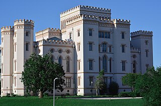
Baton Rouge is the capital city of the U.S. state of Louisiana. Located on the eastern bank of the Mississippi River, it had a population of 227,470 as of 2020; it is the seat of Louisiana's most populous parish (county-equivalent), East Baton Rouge Parish, and the center of Louisiana's second-largest metropolitan area and city, Greater Baton Rouge.

St. Tammany Parish is a parish located in the U.S. state of Louisiana named after Tamanend, the legendary Lenape Chief of Chiefs and the "Patron Saint of America." At the 2020 census, the population was 264,570, making it the fourth-most populous parish in Louisiana. The parish seat is Covington. The parish was founded in 1810.

Cameron Parish is a parish in the southwest corner of the U.S. state of Louisiana. As of the 2020 census, the population was 5,617. The parish seat is Cameron. Although it is the largest parish by area in Louisiana, it has the second-smallest population in the state, ahead of only Tensas. Cameron Parish is part of the Lake Charles metropolitan statistical area.

Baker is a city in the U.S. state of Louisiana, in East Baton Rouge Parish. It is part of the Baton Rouge metropolitan statistical area, and had a population of 12,455 at the 2020 census, down from 13,895 at the 2010 U.S. census.

The Pearl River is a river in the U.S. states of Mississippi and Louisiana. It forms in Neshoba County, Mississippi from the confluence of Nanih Waiya and Tallahaga creeks, and has a meander length of 444 miles (715 km). The lower part of the river forms part of the boundary between Mississippi and Louisiana.

The Atchafalaya River is a 137-mile-long (220 km) distributary of the Mississippi River and Red River in south central Louisiana in the United States. It flows south, just west of the Mississippi River, and is the fifth largest river in North America, by discharge. The name Atchafalaya comes from Choctaw for 'long river', from hachcha, 'river', and falaya, 'long'.

The Mississippi River Delta is the confluence of the Mississippi River with the Gulf of Mexico in Louisiana, southeastern United States. The river delta is a three-million-acre area of land that stretches from Vermilion Bay on the west, to the Chandeleur Islands in the east, on Louisiana's southeastern coast. It is part of the Gulf of Mexico and the Louisiana coastal plain, one of the largest areas of coastal wetlands in the United States. The Mississippi River Delta is the 7th largest river delta on Earth (USGS) and is an important coastal region for the United States, containing more than 2.7 million acres of coastal wetlands and 37% of the estuarine marsh in the conterminous U.S. The coastal area is the nation's largest drainage basin and drains about 41% of the contiguous United States into the Gulf of Mexico at an average rate of 470,000 cubic feet per second.

Hurricane Katrina was a devastating and deadly Category 5 Atlantic hurricane that caused 1,392 fatalities and damages estimated at $186.3 billion in late August 2005, particularly in the city of New Orleans and its surrounding area. Katrina was the twelfth tropical cyclone, the fifth hurricane, and the third major hurricane of the 2005 Atlantic hurricane season. It was also the fourth-most intense Atlantic hurricane to make landfall in the contiguous United States, gauged by barometric pressure.

Russel Luke Honoré is a retired lieutenant general who served as the 33rd commanding general of the U.S. First Army at Fort Gillem, Georgia. He is best known for serving as commander of Joint Task Force Katrina responsible for coordinating military relief efforts for Hurricane Katrina–affected areas across the Gulf Coast and as the 2nd Infantry Division's commander while stationed in South Korea. He served until his retirement from the Army on January 11, 2008. Honoré is sometimes known as "The Ragin' Cajun".

The wetlands of Louisiana are water-saturated coastal and swamp regions of southern Louisiana, often called 'Bayou'.
The National Wetlands Research Center (NWRC) was founded in 1975 as part of the U.S. Fish and Wildlife Service's (USFWS) Office of Biological Services. Its headquarters are located in Lafayette, Louisiana.

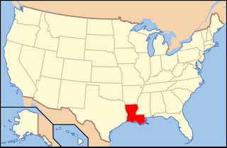
The following outline is provided as an overview of and topical guide to the U.S. state of Louisiana:
Melanie Ann Hebert is an American journalist. She formerly anchored the weekday morning news at the city's NBC affiliate WDSU and anchoring weekday mornings at the CBS affiliate WWL-TV in New Orleans. Hebert has also appeared in several films and TV shows as a news reporter.
The Delaware Geological Survey (DGS) is a scientific agency for the State of Delaware, located at the University of Delaware (UD) which conducts geologic and hydrologic research, service, and exploration. The mission of the DGS is to provide objective earth science information, advice, and service to citizens, policymakers, industries, and educational institutions of Delaware. The DGS became formally affiliated with the university's College of Earth, Ocean, and Environment (CEOE) in July 2008. Most DGS scientists have secondary faculty appointments in the College's Department of Geological Sciences.
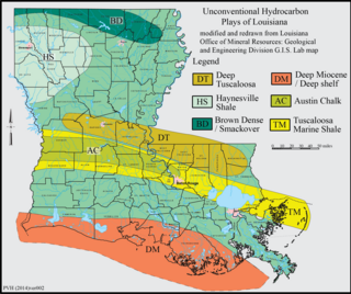
The Brown Dense limestone is an informal name used by petroleum geologists for a layer of rock that lies beneath large parts of southern Arkansas and northwest Louisiana. The Brown Dense is a 300- to 500-foot thick interval within organic-rich, fine-grained carbonate rock that comprise the Lower Member of the Smackover Formation. Within this area, the Lower Smackover Member lies at depths of 8,000 to 10,000 feet beneath the land surface.
The Louisiana Business & Technology Center (LBTC) at Louisiana State University plays an important role to the state's flagship university, Louisiana State University as a part of LSU's Office of Research and Economic Development. LBTC's primary goal is to increase the economic growth of Louisiana by enhancing the development of small businesses and assisting in the development of new businesses. The center is ranked among the top ten entrepreneur programs in the nation. In 1988 it was jointly funded through LSU and the Greater Baton Rouge Chamber of Commerce to foster economic growth in Louisiana by providing businesses with applications and tools necessary for growth and survival in the real world. It comprises the Louisiana Technology Transfer Office (LTTO), the LBTC Business Incubator, and the LSU Student Incubator.
Paleontology in Louisiana refers to paleontological research occurring within or conducted by people from the U.S. state of Louisiana. Outcrops of fossil-bearing sediments and sedimentary rocks within Louisiana are quite rare. In part, this is because Louisiana’s semi-humid climate results in the rapid weathering and erosion of any exposures and the growth of thick vegetation that conceal any fossil-bearing strata. In addition, Holocene alluvial sediments left behind by rivers like the Mississippi, Red, and Ouachita, as well as marsh deposits, cover about 55% of Louisiana and deeply bury local fossiliferous strata.
The Tuscaloosa Marine Shale is a 90-million-year-old Late Cretaceous sedimentary rock formation across the Gulf Coast region of the United States.

Alma Dawson is an American scholar of librarianship. She retired as Russell B. Long Professor at the School of Library & Information Science, Louisiana State University in 2014 and was awarded Emeritus status in 2015. In 2019 Dr. Dawson was honored with the Essae Martha Culver Distinguished Service Award from the Louisiana Library Association which honors a librarian whose professional service and achievements, whose leadership in Louisiana association work, and whose lifetime accomplishments in a field of librarianship within the state merit recognition of particular value to Louisiana librarianship.
References
- ↑ Anonymous (2008a) General Information Archived 2013-04-02 at the Wayback Machine , Louisiana State University, Baton Rouge, Louisiana.
- 1 2 Anonymous (ndb) Publication Catalog Archived 2011-11-25 at the Wayback Machine , Louisiana Geological Survey , Baton Rouge, Louisiana.
- ↑ Durham, L. S. (2011a) Similar in age and lithology to Eagle Ford Tuscaloosa Another Shale Playground. AAPG Explorer, August 2011.
- ↑ Chacko J. J., B. L. Jones, J. E. Moncrief, R. Bourgeois, and B. J. Harder (1997) An Unproven Unconventional Seven Billion Barrel Oil Resource - the Tuscaloosa Marine Shale. Archived 2012-09-16 at the Wayback Machine LSU Basin Research Institute Bulletin. vol. 7, pp. 1-22.
- ↑ Durham, L. S. (2011b) Drastic budget cuts spell doom. What? No Geological Survey in Louisiana? AAPG Explorer, August 2011.
- ↑ Petzet, A. (2011) Surviving in Louisiana. Oil and Gas Journal. vol. 109, no. 22, (May 2011).
- ↑ Anonymous (2008b) Louisiana Geological Survey to Continue Surface Geologic Mapping of State. Archived 2015-03-27 at the Wayback Machine , Center for Energy Studies, Louisiana State University, Baton Rouge, Louisiana.
- ↑ Anonymous (2010) National Cooperative Geologic Mapping Program (Louisiana). Archived 2013-02-14 at the Wayback Machine , State Mapping (STATEMAP) Information Sheets., United States Geological Survey, Denver, Colorado.
- ↑ Anonymous (nda) Maps Archived 2013-04-09 at the Wayback Machine , Louisiana Geological Survey, Baton Rouge, Louisiana.
- ↑ Anonymous (2008c) LGS Researcher Featured in Meteor Crater News Story. Archived 2012-03-21 at the Wayback Machine Center for Energy Studies, Louisiana State University Baton Rouge, LA 70803. Retrieved 2011-27-03.
- ↑ Anonymous (2005) USGS National Wetlands Research Center Provides Geospatial Technology to Assist in the Hurricane Katrina Search and Recovery Efforts. Archived 2013-02-20 at the Wayback Machine United States Geological Survey, Lafayette, Louisiana.
- ↑ Conzelmann, C.P., W. Sleavin, and B. Couvillion (2005) Using Geospatial Technology To Process 911 Calls After Hurricanes Katrina and Rita. National Wetlands Research Center. Circular no. 1306-3B, United States Geological Survey, Reston, Virginia.
- ↑ Anonymous (2010) Educational Outreach Activities. Louisiana Geological Survey NewsInsights. vol. 20, no. 1, p. 8.