Geotechnical engineering, also known as geotechnics, is the branch of civil engineering concerned with the engineering behavior of earth materials. It uses the principles of soil mechanics and rock mechanics to solve its engineering problems. It also relies on knowledge of geology, hydrology, geophysics, and other related sciences.

Topography is the study of the forms and features of land surfaces. The topography of an area may refer to the land forms and features themselves, or a description or depiction in maps.
In archaeology, geophysical survey is ground-based physical sensing techniques used for archaeological imaging or mapping. Remote sensing and marine surveys are also used in archaeology, but are generally considered separate disciplines. Other terms, such as "geophysical prospection" and "archaeological geophysics" are generally synonymous.

Prospecting is the first stage of the geological analysis of a territory. It is the search for minerals, fossils, precious metals, or mineral specimens. It is also known as fossicking.
Geologic modelling,geological modelling or geomodelling is the applied science of creating computerized representations of portions of the Earth's crust based on geophysical and geological observations made on and below the Earth surface. A geomodel is the numerical equivalent of a three-dimensional geological map complemented by a description of physical quantities in the domain of interest. Geomodelling is related to the concept of Shared Earth Model; which is a multidisciplinary, interoperable and updatable knowledge base about the subsurface.

In archaeology, survey or field survey is a type of field research by which archaeologists search for archaeological sites and collect information about the location, distribution and organization of past human cultures across a large area. Archaeologists conduct surveys to search for particular archaeological sites or kinds of sites, to detect patterns in the distribution of material culture over regions, to make generalizations or test hypotheses about past cultures, and to assess the risks that development projects will have adverse impacts on archaeological heritage.
Exploration geophysics is an applied branch of geophysics and economic geology, which uses physical methods at the surface of the Earth, such as seismic, gravitational, magnetic, electrical and electromagnetic, to measure the physical properties of the subsurface, along with the anomalies in those properties. It is most often used to detect or infer the presence and position of economically useful geological deposits, such as ore minerals; fossil fuels and other hydrocarbons; geothermal reservoirs; and groundwater reservoirs. It can also be used to detect the presence of unexploded ordnance.

Soil map is a geographical representation showing diversity of soil types and/or soil properties in the area of interest. It is typically the result of a soil survey inventory, i.e. soil survey. Soil maps are most commonly used for land evaluation, spatial planning, agricultural extension, environmental protection and similar projects. Traditional soil maps typically show only general distribution of soils, accompanied by the soil survey report. Many new soil maps are derived using digital soil mapping techniques. Such maps are typically richer in context and show higher spatial detail than traditional soil maps. Soil maps produced using (geo)statistical techniques also include an estimate of the model uncertainty.

Magnetotellurics (MT) is an electromagnetic geophysical method for inferring the earth's subsurface electrical conductivity from measurements of natural geomagnetic and geoelectric field variation at the Earth's surface.

Electrical resistivity tomography (ERT) or electrical resistivity imaging (ERI) is a geophysical technique for imaging sub-surface structures from electrical resistivity measurements made at the surface, or by electrodes in one or more boreholes. If the electrodes are suspended in the boreholes, deeper sections can be investigated. It is closely related to the medical imaging technique electrical impedance tomography (EIT), and mathematically is the same inverse problem. In contrast to medical EIT, however, ERT is essentially a direct current method. A related geophysical method, induced polarization, measures the transient response and aims to determine the subsurface chargeability properties.

An aeromagnetic survey is a common type of geophysical survey carried out using a magnetometer aboard or towed behind an aircraft. The principle is similar to a magnetic survey carried out with a hand-held magnetometer, but allows much larger areas of the Earth's surface to be covered quickly for regional reconnaissance. The aircraft typically flies in a grid-like pattern with height and line spacing determining the resolution of the data.
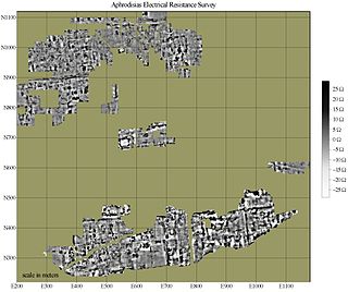
Electrical resistance surveys are one of a number of methods used in archaeological geophysics, as well as in engineering geological investigations. In this type of survey electrical resistance meters are used to detect and map subsurface archaeological features and patterning.
Digital geologic mapping is the process by which geological features are observed, analyzed, and recorded in the field and displayed in real-time on a computer or personal digital assistant (PDA). The primary function of this emerging technology is to produce spatially referenced geologic maps that can be utilized and updated while conducting field work.
Geomathematics is the application of mathematical methods to solve problems in geosciences, including geology and geophysics, and particularly geodynamics and seismology.

Near-surface geophysics is the use of geophysical methods to investigate small-scale features in the shallow subsurface. It is closely related to applied geophysics or exploration geophysics. Methods used include seismic refraction and reflection, gravity, magnetic, electric, and electromagnetic methods. Many of these methods were developed for oil and mineral exploration but are now used for a great variety of applications, including archaeology, environmental science, forensic science, military intelligence, geotechnical investigation, treasure hunting, and hydrogeology. In addition to the practical applications, near-surface geophysics includes the study of biogeochemical cycles.

Forensic geophysics is a branch of forensic science and is the study, the search, the localization and the mapping of buried objects or elements beneath the soil or the water, using geophysics tools for legal purposes. There are various geophysical techniques for forensic investigations in which the targets are buried and have different dimensions. Geophysical methods have the potential to aid the search and the recovery of these targets because they can non-destructively and rapidly investigate large areas where a suspect, illegal burial or, in general, a forensic target is hidden in the subsoil. When in the subsurface there is a contrast of physical properties between a target and the material in which it is buried, it is possible to individuate and define precisely the concealing place of the searched target. It is also possible to recognize evidences of human soil occupation or excavation, both recent and older. Forensic geophysics is an evolving technique that is gaining popularity and prestige in law enforcement.
Subsurface utility engineering (SUE) refers to a branch of engineering that involves managing certain risks associated with utility mapping at appropriate quality levels, utility coordination, utility relocation design and coordination, utility condition assessment, communication of utility data to concerned parties, utility relocation cost estimates, implementation of utility accommodation policies, and utility design.

BRGM is France's public reference institution in Earth Science applications for the management of surface and subsurface resources and risks. It also deals with geological surveys of French territory.

Remote sensing is used in the geological sciences as a data acquisition method complementary to field observation, because it allows mapping of geological characteristics of regions without physical contact with the areas being explored. About one-fourth of the Earth's total surface area is exposed land where information is ready to be extracted from detailed earth observation via remote sensing. Remote sensing is conducted via detection of electromagnetic radiation by sensors. The radiation can be naturally sourced, or produced by machines and reflected off of the Earth surface. The electromagnetic radiation acts as an information carrier for two main variables. First, the intensities of reflectance at different wavelengths are detected, and plotted on a spectral reflectance curve. This spectral fingerprint is governed by the physio-chemical properties of the surface of the target object and therefore helps mineral identification and hence geological mapping, for example by hyperspectral imaging. Second, the two-way travel time of radiation from and back to the sensor can calculate the distance in active remote sensing systems, for example, Interferometric synthetic-aperture radar. This helps geomorphological studies of ground motion, and thus can illuminate deformations associated with landslides, earthquakes, etc.

Geological engineering is a discipline of engineering concerned with the application of geological science and engineering principles to fields, such as civil engineering, mining, environmental engineering, and forestry, among others. The work of geological engineers often directs or supports the work of other engineering disciplines such as assessing the suitability of locations for civil engineering, environmental engineering, mining operations, and oil and gas projects by conducting geological, geoenvironmental, geophysical, and geotechnical studies. They are involved with impact studies for facilities and operations that affect surface and subsurface environments. The engineering design input and other recommendations made by geological engineers on these projects will often have a large impact on construction and operations. Geological engineers plan, design, and implement geotechnical, geological, geophysical, hydrogeological, and environmental data acquisition. This ranges from manual ground-based methods to deep drilling, to geochemical sampling, to advanced geophysical techniques and satellite surveying. Geological engineers are also concerned with the analysis of past and future ground behaviour, mapping at all scales, and ground characterization programs for specific engineering requirements. These analyses lead geological engineers to make recommendations and prepare reports which could have major effects on the foundations of construction, mining, and civil engineering projects. Some examples of projects include rock excavation, building foundation consolidation, pressure grouting, hydraulic channel erosion control, slope and fill stabilization, landslide risk assessment, groundwater monitoring, and assessment and remediation of contamination. In addition, geological engineers are included on design teams that develop solutions to surface hazards, groundwater remediation, underground and surface excavation projects, and resource management. Like mining engineers, geological engineers also conduct resource exploration campaigns, mine evaluation and feasibility assessments, and contribute to the ongoing efficiency, sustainability, and safety of active mining projects